
Geology
This article needs additional citations for verification. (May 2023) |
| Part of a series on |
| Geology |
|---|
 |


.jpg)
Geology (from
Geology describes the
Geological material


The majority of geological data comes from research on solid Earth materials. Meteorites and other extraterrestrial natural materials are also studied by geological methods.
Mineral
Minerals are naturally occurring elements and compounds with a definite homogeneous chemical composition and ordered atomic composition.
Each mineral has distinct physical properties, and there are many tests to determine each of them. Minerals are often identified through these tests. The specimens can be tested for:[5]
- Color: Minerals are grouped by their color. Mostly diagnostic but impurities can change a mineral's color.
- Streak: Performed by scratching the sample on a porcelain plate. The color of the streak can help identify the mineral.
- Hardness: The resistance of a mineral to scratching or indentation.
- Breakage pattern: A mineral can either show fracture or cleavage, the former being breakage of uneven surfaces, and the latter a breakage along closely spaced parallel planes.
- Luster: Quality of light reflected from the surface of a mineral. Examples are metallic, pearly, waxy, dull.
- Specific gravity: the weight of a specific volume of a mineral.
- Effervescence: Involves dripping hydrochloric acid on the mineral to test for fizzing.
- Magnetism: Involves using a magnet to test for magnetism.
- Taste: Minerals can have a distinctive taste such as table salt).
Rock
A rock is any naturally occurring solid mass or aggregate of minerals or
When a rock
To study all three types of rock, geologists evaluate the minerals of which they are composed and their other physical properties, such as texture and fabric.
Unlithified material
Geologists also study unlithified materials (referred to as
Magma
Whole-Earth structure
Plate tectonics
In the 1960s, it was discovered that the Earth's
There is an intimate coupling between the movement of the plates on the surface and the convection of the mantle (that is, the heat transfer caused by the slow movement of ductile mantle rock). Thus, oceanic parts of plates and the adjoining mantle convection currents always move in the same direction – because the oceanic lithosphere is actually the rigid upper thermal boundary layer of the convecting mantle. This coupling between rigid plates moving on the surface of the Earth and the convecting mantle is called plate tectonics.
The development of plate tectonics has provided a physical basis for many observations of the solid Earth. Long linear regions of geological features are explained as plate boundaries:[11]

- Mid-ocean ridges, high regions on the seafloor where hydrothermal vents and volcanoes exist, are seen as divergent boundaries, where two plates move apart.
- Arcs of volcanoes and earthquakes are theorized as convergent boundaries, where one plate subducts, or moves, under another.
- Transform boundaries, such as the San Andreas Faultsystem, are where plates slide horizontally past each other.
Plate tectonics has provided a mechanism for
Earth structure


Advances in
Seismologists can use the arrival times of
Mineralogists have been able to use the pressure and temperature data from the seismic and modeling studies alongside knowledge of the elemental composition of the Earth to reproduce these conditions in experimental settings and measure changes within the crystal structure. These studies explain the chemical changes associated with the major seismic discontinuities in the mantle and show the crystallographic structures expected in the inner core of the Earth.
Geological time
The geological time scale encompasses the history of the Earth.
Timescale of the Earth
The following five timelines show the geologic time scale to scale. The first shows the entire time from the formation of the Earth to the present, but this gives little space for the most recent eon. The second timeline shows an expanded view of the most recent eon. In a similar way, the most recent era is expanded in the third timeline, the most recent period is expanded in the fourth timeline, and the most recent epoch is expanded in the fifth timeline.
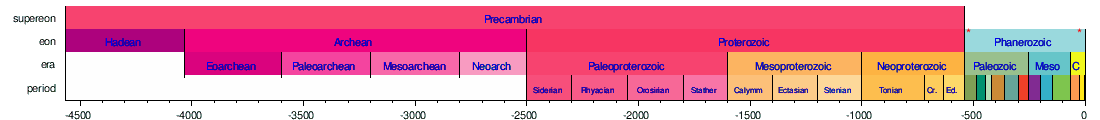


Horizontal scale is Millions of years (above timelines) / Thousands of years (below timeline)

Important milestones on Earth
- 4.567 Ga (gigaannum: billion years ago): Solar system formation[14]
- 4.54 Ga: Accretion, or formation, of Earth[15][16]
- c. 4 Ga: End of Late Heavy Bombardment, the first life
- c. 3.5 Ga: Start of photosynthesis
- c. 2.3 Ga: Oxygenated atmosphere, first snowball Earth
- 730–635 Ma(megaannum: million years ago): second snowball Earth
- 541 ± 0.3 Ma: Cambrian explosion – vast multiplication of hard-bodied life; first abundant fossils; start of the Paleozoic
- c. 380 Ma: First vertebrate land animals
- 250 Ma: Permian-Triassic extinction – 90% of all land animals die; end of Paleozoic and beginning of Mesozoic
- 66 Ma: Cretaceous–Paleogene extinction – Dinosaurs die; end of Mesozoic and beginning of Cenozoic
- c. 7 Ma: First homininsappear
- 3.9 Ma: First Homo sapiens, appear
- 200 ka(kiloannum: thousand years ago): First modern Homo sapiens appear in East Africa
Timescale of the Moon

Timescale of Mars

Dating methods
Relative dating
Methods for relative dating were developed when geology first emerged as a natural science. Geologists still use the following principles today as a means to provide information about geological history and the timing of geological events.
The
The
The
The

The principle of original horizontality states that the deposition of sediments occurs as essentially horizontal beds. Observation of modern marine and non-marine sediments in a wide variety of environments supports this generalization (although cross-bedding is inclined, the overall orientation of cross-bedded units is horizontal).[19]
The principle of superposition states that a sedimentary rock layer in a tectonically undisturbed sequence is younger than the one beneath it and older than the one above it. Logically a younger layer cannot slip beneath a layer previously deposited. This principle allows sedimentary layers to be viewed as a form of the vertical timeline, a partial or complete record of the time elapsed from deposition of the lowest layer to deposition of the highest bed.[19]
The principle of faunal succession is based on the appearance of fossils in sedimentary rocks. As organisms exist during the same period throughout the world, their presence or (sometimes) absence provides a relative age of the formations where they appear. Based on principles that William Smith laid out almost a hundred years before the publication of Charles Darwin's theory of evolution, the principles of succession developed independently of evolutionary thought. The principle becomes quite complex, however, given the uncertainties of fossilization, localization of fossil types due to lateral changes in habitat (facies change in sedimentary strata), and that not all fossils formed globally at the same time.[20]
Absolute dating

Geologists also use methods to determine the absolute age of rock samples and geological events. These dates are useful on their own and may also be used in conjunction with relative dating methods or to calibrate relative methods.[21]
At the beginning of the 20th century, advancement in geological science was facilitated by the ability to obtain accurate absolute dates to geological events using
For many geological applications,
Fractionation of the
Other methods are used for more recent events.
Geological development of an area

A. Strike-slip faults occur when rock units slide past one another.
B. Normal faults occur when rocks are undergoing horizontal extension.
C. Reverse (or thrust) faults occur when rocks are undergoing horizontal shortening.

The geology of an area changes through time as rock units are deposited and inserted, and deformational processes alter their shapes and locations.
Rock units are first emplaced either by deposition onto the surface or intrusion into the
, push upwards into the overlying rock, and crystallize as they intrude.After the initial sequence of rocks has been deposited, the rock units can be
When rock units are placed under horizontal
.png)
Even higher pressures and temperatures during horizontal shortening can cause both folding and
Extension causes the rock units as a whole to become longer and thinner. This is primarily accomplished through
Where rock units slide past one another,

The addition of new rock units, both depositionally and intrusively, often occurs during deformation. Faulting and other deformational processes result in the creation of topographic gradients, causing material on the rock unit that is increasing in elevation to be eroded by hillslopes and channels. These sediments are deposited on the rock unit that is going down. Continual motion along the fault maintains the topographic gradient in spite of the movement of sediment and continues to create
All of these processes do not necessarily occur in a single environment and do not necessarily occur in a single order. The
Investigative methods

Geologists use a number of fields, laboratory, and numerical modeling methods to decipher Earth history and to understand the processes that occur on and inside the Earth. In typical geological investigations, geologists use primary information related to petrology (the study of rocks), stratigraphy (the study of sedimentary layers), and structural geology (the study of positions of rock units and their deformation). In many cases, geologists also study modern soils, rivers, landscapes, and glaciers; investigate past and current life and biogeochemical pathways, and use geophysical methods to investigate the subsurface. Sub-specialities of geology may distinguish endogenous and exogenous geology.[24]
Field methods
Geological
- Geological mapping[25]
- Structural mapping: identifying the locations of major rock units and the faults and folds that led to their placement there.
- Stratigraphic mapping: pinpointing the locations of isopachsof equal thickness of sedimentary rock
- Surficial mapping: recording the locations of soils and surficial deposits
- Surveying of topographic features
- compilation of topographic maps[26]
- Work to understand change across landscapes, including:
- Patterns of erosion and deposition
- River-channel change through migration and avulsion
- Hillslope processes
- Subsurface mapping through geophysical methods[27]
- These methods include:
- They aid in:
- Hydrocarbon exploration
- Finding groundwater
- Locating buried archaeological artifacts
- High-resolution stratigraphy
- Measuring and describing stratigraphic sections on the surface
- Well drilling and logging
- Biogeochemistry and geomicrobiology[28]
- Collecting samples to:
- determine biochemical pathways
- identify new speciesof organisms
- identify new chemical compounds
- determine
- and to use these discoveries to:
- understand early life on Earth and how it functioned and metabolized
- find important compounds for use in pharmaceuticals
- Collecting samples to:
- Paleontology: excavation of fossil material
- Collection of samples for geochronology and thermochronology[29]
- Glaciology: measurement of characteristics of glaciers and their motion[30]


Petrology
In addition to identifying rocks in the field (
Petrologists can also use

Structural geology
Structural geologists use microscopic analysis of oriented thin sections of geological samples to observe the fabric within the rocks, which gives information about strain within the crystalline structure of the rocks. They also plot and combine measurements of geological structures to better understand the orientations of faults and folds to reconstruct the history of rock deformation in the area. In addition, they perform analog and numerical experiments of rock deformation in large and small settings.
The analysis of structures is often accomplished by plotting the orientations of various features onto stereonets. A stereonet is a stereographic projection of a sphere onto a plane, in which planes are projected as lines and lines are projected as points. These can be used to find the locations of fold axes, relationships between faults, and relationships between other geological structures.
Among the most well-known experiments in structural geology are those involving orogenic wedges, which are zones in which mountains are built along convergent tectonic plate boundaries.[40] In the analog versions of these experiments, horizontal layers of sand are pulled along a lower surface into a back stop, which results in realistic-looking patterns of faulting and the growth of a critically tapered (all angles remain the same) orogenic wedge.[41] Numerical models work in the same way as these analog models, though they are often more sophisticated and can include patterns of erosion and uplift in the mountain belt.[42] This helps to show the relationship between erosion and the shape of a mountain range. These studies can also give useful information about pathways for metamorphism through pressure, temperature, space, and time.[43]
Stratigraphy
.jpg)
In the laboratory, stratigraphers analyze samples of stratigraphic sections that can be returned from the field, such as those from
In the laboratory,
Planetary geology

With the advent of
Although the Greek-language-origin prefix
Although planetary geologists are interested in studying all aspects of other planets, a significant focus is to search for evidence of past or present life on other worlds. This has led to many missions whose primary or ancillary purpose is to examine planetary bodies for evidence of life. One of these is the
Applied geology
Economic geology
Economic geology is a branch of geology that deals with aspects of economic minerals that humankind uses to fulfill various needs. Economic minerals are those extracted profitably for various practical uses. Economic geologists help locate and manage the Earth's natural resources, such as petroleum and coal, as well as mineral resources, which include metals such as iron, copper, and uranium.
Mining geology
.Petroleum geology

Petroleum geologists study the locations of the subsurface of the Earth that can contain extractable hydrocarbons, especially petroleum and natural gas. Because many of these reservoirs are found in sedimentary basins,[50] they study the formation of these basins, as well as their sedimentary and tectonic evolution and the present-day positions of the rock units.
Engineering geology
Engineering geology is the application of geological principles to engineering practice for the purpose of assuring that the geological factors affecting the location, design, construction, operation, and maintenance of engineering works are properly addressed. Engineering geology is distinct from geological engineering, particularly in North America.

In the field of civil engineering, geological principles and analyses are used in order to ascertain the mechanical principles of the material on which structures are built. This allows tunnels to be built without collapsing, bridges and skyscrapers to be built with sturdy foundations, and buildings to be built that will not settle in clay and mud.[51]
Hydrology
Geology and geological principles can be applied to various environmental problems such as
Paleoclimatology
Geologists also obtain data through stratigraphy,
Natural hazards

Geologists and geophysicists study natural hazards in order to enact safe building codes and warning systems that are used to prevent loss of property and life.[58] Examples of important natural hazards that are pertinent to geology (as opposed those that are mainly or only pertinent to meteorology) are:
History
The study of the physical material of the Earth dates back at least to ancient Greece when Theophrastus (372–287 BCE) wrote the work Peri Lithon (On Stones). During the Roman period, Pliny the Elder wrote in detail of the many minerals and metals, then in practical use – even correctly noting the origin of amber. Additionally, in the 4th century BCE Aristotle made critical observations of the slow rate of geological change. He observed the composition of the land and formulated a theory where the Earth changes at a slow rate and that these changes cannot be observed during one person's lifetime. Aristotle developed one of the first evidence-based concepts connected to the geological realm regarding the rate at which the Earth physically changes.[60][61]
Georgius Agricola (1494–1555) published his groundbreaking work De Natura Fossilium in 1546 and is seen as the founder of geology as a scientific discipline.[66]
Nicolas Steno (1638–1686) is credited with the law of superposition, the principle of original horizontality, and the principle of lateral continuity: three defining principles of stratigraphy.
The word geology was first used by
In 1763, Mikhail Lomonosov published his treatise On the Strata of Earth.[75] His work was the first narrative of modern geology, based on the unity of processes in time and explanation of the Earth's past from the present.[76]
James Hutton (1726–1797) is often viewed as the first modern geologist.[77] In 1785 he presented a paper entitled Theory of the Earth to the Royal Society of Edinburgh. In his paper, he explained his theory that the Earth must be much older than had previously been supposed to allow enough time for mountains to be eroded and for sediments to form new rocks at the bottom of the sea, which in turn were raised up to become dry land. Hutton published a two-volume version of his ideas in 1795.[78]
Followers of Hutton were known as Plutonists because they believed that some rocks were formed by vulcanism, which is the deposition of lava from volcanoes, as opposed to the Neptunists, led by Abraham Werner, who believed that all rocks had settled out of a large ocean whose level gradually dropped over time.
The first
Much of 19th-century geology revolved around the question of the
Some of the most significant advances in 20th-century geology have been the development of the theory of
-
 German mineralogist, founder of geology as a scientific field
 -
 Mikhail Lomonosov, Russian polymath, author of the first systematic treatise in scientific geology (1763)
 -
 modern geology
 -
 geophysicist and father of plate tectonics
 -
 The volcanologist David A. Johnston 13 hours before his death at the
1980 eruption of Mount St. Helens

.jpg)


.jpg)
- Earth system science
- Economic geology
- Engineering geology
- Environmental geology
- Environmental science
- Geoarchaeology
- Geochemistry
- Geochronology
- Geodetics
- Geography
- Geological engineering
- Geological modelling
- Geometallurgy
- Geomicrobiology
- Geomorphology
- Geomythology
- Geophysics
- Glaciology
- Historical geology
- Hydrogeology
- Meteorology
- Mineralogy
- Oceanography
- Paleoclimatology
- Paleontology
- Petrology
- Petrophysics
- Planetary geology
- Plate tectonics
- Regional geology
- Sedimentology
- Seismology
- Soil science
- Pedology (soil study)
- Speleology
- Stratigraphy
- Structural geology
- Systems geology
- Tectonics
- Volcanology
See also
- Glossary of geology
- Geoprofessions
- Geotourism
- Glossary of geology terms
- Index of geology articles
- IUGS)
- Outline of geology
- Timeline of geology
References
- ^ Harper, Douglas. "geology". Online Etymology Dictionary.
- Perseus Project
- ^ "What is geology?". The Geological Society. Retrieved 31 May 2023.
- (PDF) from the original on 2019-12-12. Retrieved 2019-06-29.
- ^ "Mineral Identification Tests". Geoman's Mineral ID Tests. Archived from the original on 9 May 2017. Retrieved 17 April 2017.
- ISBN 978-0-691-03452-2.)
{{cite book}}: CS1 maint: date and year (link - ^ "Surficial Geologic Maps" Archived 2016-02-16 at the Wayback Machine in New Hampshire Geological Survey, Geologic maps. des.nh.gov
- ^ "OCRE GeoMap". OCRE Geoscience Services.
- ^ Hess, H.H. (November 1, 1962) "History Of Ocean Basins Archived 2009-10-16 at the Wayback Machine", pp. 599–620 in Petrologic studies: a volume in honor of A.F. Buddington. A.E.J. Engel, Harold L. James, and B.F. Leonard (eds.). Geological Society of America.
- ISBN 978-0-16-048220-5. Archivedfrom the original on 10 August 2011. Retrieved 13 March 2009.
- ISBN 978-0-16-048220-5. Archivedfrom the original on 10 August 2011. Retrieved 13 March 2009.
- ISBN 978-0-486-61708-4.
- ^ International Commission on Stratigraphy Archived September 20, 2005, at the Wayback Machine. stratigraphy.org
- ^ S2CID 24923770.
- ^ .
- ^ ISBN 978-0-8047-2331-2.
- EJ Brill, 1963.
- ISBN 978-0-470-38774-0.
- ^ a b c Olsen, Paul E. (2001). "Steno's Principles of Stratigraphy". Dinosaurs and the History of Life. Columbia University. Archived from the original on 2008-05-09. Retrieved 2009-03-14.
- ^ As recounted in Simon Winchester, The Map that Changed the World (New York: HarperCollins, 2001) pp. 59–91.
- doi:10.1016/S0012-821X(98)00050-8. Archived from the original(PDF) on 2016-12-26. Retrieved 2018-01-29.
- ISBN 978-0-582-06701-1.
- ISBN 978-0-02-336450-1.
- ISBN 978-0-8137-1203-1. Archivedfrom the original on 2017-01-20. Retrieved 2016-08-24.
[...] the historic dichotomy between 'hard rock' and 'soft rock' geologists, i.e. scientists working mainly with endogenous and exogenous processes, respectively [...] endogenous forces mainly defining the developments below Earth's crust and the exogenous forces mainly defining the developments on top of and above Earth's crust.
- ISBN 978-0-471-82902-7.
- ^ "USGS Topographic Maps". United States Geological Survey. Archived from the original on 2009-04-12. Retrieved 2009-04-11.
- ISBN 978-0-393-92637-8.
- ISBN 978-0-250-40218-2.
- ISBN 978-0-19-510920-7.
- ISBN 978-0-470-84426-7.
- ISBN 978-0-19-506024-9.
- .
- .
- .
- )
- S2CID 129193823.
- ISBN 978-0-7637-3448-0.
- ISBN 978-0-939950-34-8.
- ISSN 1460-2415.
- .
- .
- .
- .
- ^ .
- ISBN 978-0-89181-033-9.
- .
- .
- ^ Toscano, M; Lundberg, Joyce (1999). "Submerged Late Pleistocene reefs on the tectonically-stable S.E. Florida margin: high-precision geochronology, stratigraphy, resolution of Substage 5a sea-level elevation, and orbital forcing". Quaternary Science Reviews. 18 (6): 753–767. .
- S2CID 118743781.
- ISBN 978-0-12-636370-8.
- ISBN 978-0-534-55144-5.
- ^ from the original on 2020-10-31. Retrieved 2020-08-29.
- .
- .
- S2CID 4268239.
- S2CID 129496709.
- (PDF) from the original on 11 April 2019. Retrieved 28 August 2015.
- ^ USGS Natural Hazards Gateway Archived 2010-09-23 at the Wayback Machine. usgs.gov
- ^ ISBN 978-0-06-093180-3.
- ^ Moore, Ruth. The Earth We Live On. New York: Alfred A. Knopf, 1956. p. 13
- ^ Aristotle. Meteorology. Book 1, Part 14
- ISBN 978-92-3-102719-2.
- ^ Toulmin, S., and Goodfield, J. (1965) The Ancestry of science: The Discovery of Time, Hutchinson & Co., London, p. 64
- ^ Al-Rawi, Munin M. (November 2002). The Contribution of Ibn Sina (Avicenna) to the development of Earth Sciences (PDF) (Report). Manchester, UK: Foundation for Science Technology and Civilisation. Publication 4039. Archived (PDF) from the original on 2012-10-03. Retrieved 2008-07-22.
- ISBN 978-0-521-31560-9.
- ^ "Georgius Agricola (1494–1555)".
- ^ From his will (Testamento d'Ullisse Aldrovandi) of 1603, which is reproduced in: Fantuzzi, Giovanni, Memorie della vita di Ulisse Aldrovandi, medico e filosofo bolognese … (Bologna, (Italy): Lelio dalla Volpe, 1774). From p. 81: Archived 2017-02-16 at the Wayback Machine " … & anco la Giologia, ovvero de Fossilibus; … " ( … and likewise geology, or [the study] of things dug from the earth; … )
- ISBN 978-88-7381-056-8. Archivedfrom the original on 2016-04-20. Retrieved 2015-11-14.
- ^ Deluc, Jean André de, Lettres physiques et morales sur les montagnes et sur l'histoire de la terre et de l'homme. … [Physical and moral letters on mountains and on the history of the Earth and man. … ], vol. 1 (Paris, France: V. Duchesne, 1779), pp. 4, 5, and 7. From p. 4: Archived 2018-11-22 at the Wayback Machine "Entrainé par les liaisons de cet objet avec la Géologie, j'entrepris dans un second voyage de les développer à SA MAJESTÉ; … " (Driven by the connections between this subject and geology, I undertook a second voyage to develop them for Her Majesty [viz, Charlotte of Mecklenburg-Strelitz, Queen of Great Britain and Ireland]; … ) From p. 5: Archived 2018-11-22 at the Wayback Machine "Je vis que je faisais un Traité, et non une equisse de Géologie." (I see that I wrote a treatise, and not a sketch of geology.) From the footnote on p. 7: Archived 2018-11-22 at the Wayback Machine "Je répète ici, ce que j'avois dit dans ma première Préface, sur la substitution de mot Cosmologie à celui de Géologie, quoiqu'il ne s'agisse pas de l'Univers, mais seulement de la Terre: … " (I repeat here what I said in my first preface about the substitution of the word "cosmology" for that of "geology", although it is not a matter of the universe but only of the Earth: … ) [Note: A pirated edition of this book was published in 1778.]
- ^ Saussure, Horace-Bénédict de, Voyages dans les Alpes, … (Neuchatel, (Switzerland): Samuel Fauche, 1779). From pp. i–ii: Archived 2017-02-06 at the Wayback Machine "La science qui rassemble les faits, qui seuls peuvent servir de base à la Théorie de la Terre ou à la Géologie, c'est la Géographie physique, ou la description de notre Globe; … " (The science that assembles the facts which alone can serve as the basis of the theory of the Earth or of "geology", is physical geography, or the description of our globe; … )
- ^ On the controversy regarding whether Deluc or Saussure deserves priority in the use the term "geology":
- Zittel, Karl Alfred von, with Maria M. Ogilvie-Gordon, trans., History of Geology and Paleontology to the End of the Nineteenth Century (London, England: Walter Scott, 1901), p. 76.
- Geikie, Archibald, The Founders of Geology, 2nd ed. (London, England: Macmillan and Co., 1905), p. 186. Archived 2017-02-16 at the Wayback Machine
- Eastman, Charles Rochester (12 August 1904) Letter to the Editor: "Variæ Auctoritatis" Archived 2017-02-07 at the Wayback Machine, Science, 2nd series, 20 (502) : 215–217 ; see p. 216.
- Emmons, Samuel Franklin (21 October 1904) Letter to the Editor: "Variæ Auctoritatis" Archived 2017-02-07 at the Wayback Machine, Science, 2nd series, 20 (512) : 537.
- Eastman, C.R. (25 November 1904) Letter to the Editor: "Notes on the History of Scientific Nomenclature", Archived 2017-02-07 at the Wayback Machine Science, 2nd series, 20 (517) : 727–730 ; see p. 728.
- Emmons, S.F. (23 December 1904) Letter to the Editor: "The term 'geology' ", Science, 2nd series, 20 (521) : 886–887.
- Eastman, C. R. (20 January 1905) Letter to the Editor: "Deluc's 'Geological Letters'" Archived 2017-02-16 at the Wayback Machine, Science, 2nd series, 21 (525): 111.
- Emmons, S. F. (17 February 1905) Letter to the Editor: "Deluc versus de Saussure" Archived 2017-02-16 at the Wayback Machine, Science, 2nd series, 21 (529) : 274–275.
- ISBN 978-0-06-093180-3.
- ^ Escholt, Michel Pedersøn, Geologia Norvegica : det er, En kort undervisning om det vitt-begrebne jordskelff som her udi Norge skeedemesten ofuer alt Syndenfields den 24. aprilis udi nærværende aar 1657: sampt physiske, historiske oc theologiske fundament oc grundelige beretning om jordskellfs aarsager oc betydninger Archived 2017-02-16 at the Wayback Machine [Norwegian geology: that is, a brief lesson about the widely-perceived earthquake which happened here in Norway across all southern parts [on] the 24th of April in the present year 1657: together with physical, historical, and theological bases and a basic account of earthquakes' causes and meanings] (Christiania (now: Oslo), (Norway): Mickel Thomesøn, 1657). (in Danish)
- Reprinted in English as: Escholt, Michel Pedersøn with Daniel Collins, trans., Geologia Norvegica … Archived 2017-02-16 at the Wayback Machine (London, England: S. Thomson, 1663).
- ^ Kermit H., (2003) Niels Stensen, 1638–1686: the scientist who was beatified Archived 2017-01-20 at the Wayback Machine. Gracewing Publishing. p. 127.
- ISBN 978-0-8137-2485-0. Archivedfrom the original on 2021-06-24. Retrieved 2021-06-19.
- ^ Vernadsky, V. (1911) Pamyati M.V. Lomonosova. Zaprosy zhizni, 5: 257–262 (in Russian) [In memory of M.V. Lomonosov]
- ^ James Hutton: The Founder of Modern Geology Archived 2016-08-27 at the Wayback Machine American Museum of Natural History
- ^ Gutenberg ebook links: (Vol. 1 Archived 2020-09-14 at the Wayback Machine, Vol. 2 Archived 2020-08-09 at the Wayback Machine)
- ^ Maclure, William (1817). Observations on the Geology of the United States of America: With Some Remarks on the Effect Produced on the Nature and Fertility of Soils, by the Decomposition of the Different Classes of Rocks; and an Application to the Fertility of Every State in the Union, in Reference to the Accompanying Geological Map. Philadelphia: Abraham Small. Archived from the original on 2015-10-27. Retrieved 2015-11-14.
- JSTOR 1006294.
- ^ Maclure's 1809 Geological Map Archived 2014-08-14 at the Wayback Machine. davidrumsey.com
- ISBN 978-0-226-49797-6.
- .
External links
- One Geology: This interactive geological map of the world is an international initiative of the geological surveys around the globe. This groundbreaking project was launched in 2007 and contributed to the 'International Year of Planet Earth', becoming one of their flagship projects.
- Earth Science News, Maps, Dictionary, Articles, Jobs
- American Geophysical Union
- American Geosciences Institute
- European Geosciences Union
- Geological Society of America
- Geological Society of London
- Video-interviews with famous geologists
- Geology OpenTextbook
- Chronostratigraphy benchmarks
| Overviews | | |
|---|---|---|
| History of geology | ||
| Сomposition and structure | ||
| Historical geology | ||
| Motion | ||
| Water | ||
| Geodesy | ||
| Geophysics |
| |
| Applications | ||
| Occupations | ||
| ||
| Atmosphere | |
|---|---|
| Climate | |
| Continents | |
| Culture and society | |
| Environment | |
| Geodesy | |
| Geophysics | |
| Geology | |
| Oceans | |
| Natural satellite | |
| Planetary science | |
Geologic principles and processes | ||
|---|---|---|
| Stratigraphic principles |
|  |
| Petrologic principles | ||
| Geomorphologic processes | ||
| Sediment transport |
| |
| International | |
|---|---|
| National | |
| Other | |