
Siorac-de-Ribérac
Siorac-de-Ribérac | |
|---|---|
 Fireworks light up the village at its annual fete | |
 Coat of arms | |
Location of Siorac-de-Ribérac  | |
 Siorac-de-Ribérac  Siorac-de-Ribérac | |
| Coordinates: 45°11′54″N 0°21′32″E / 45.1983°N 0.3589°E | |
| Country | France |
| Region | Nouvelle-Aquitaine |
| Department | Dordogne |
| Arrondissement | Périgueux |
| Canton | Ribérac |
| Government | |
| • Mayor (2020–2026) | Jean-Pierre Chaumette[1] |
| Area 1 | 20.86 km2 (8.05 sq mi) |
| Population (2021)[2] | 254 |
| • Density | 12/km2 (32/sq mi) |
| Time zone | UTC+01:00 (CET) |
| • Summer (DST) | UTC+02:00 (CEST) |
| INSEE/Postal code | 24537 /24600 |
| Elevation | 73–105 m (240–344 ft) (avg. 177 m or 581 ft) |
| 1 French Land Register data, which excludes lakes, ponds, glaciers > 1 km2 (0.386 sq mi or 247 acres) and river estuaries. | |
Siorac-de-Ribérac (French pronunciation: [sjɔʁak də ʁibeʁak], literally Siorac of Ribérac; Occitan: Sieurac de Rabairac) is a commune in the Dordogne department in the Nouvelle-Aquitaine region of southwestern France.
Geography
The commune of Siorac-de-Ribérac lies in the forest of the Double, in the west of the
The soil is composed in part of Eocene and Oligocene sands, clays and gravels,[3] and in part of chalk of the Campanian period.[4]
The commune's lowest point, at 73 m, is to the south-west where the Rizonne leaves the commune for Vanxains and La Jemaye. The highest point, at 195 m, is to the north-east, at The Temple, at the boundary with Saint-Martin-de-Ribérac.
Church

The village church of St Peter in Chains began in 1154, during the English period in the region, Aquitaine. The 12th century freestone nave and bell tower survived. At that time, the church was part of the
Population
| Year | Pop. | ±% |
|---|---|---|
| 1962 | 249 | — |
| 1968 | 270 | +8.4% |
| 1975 | 226 | −16.3% |
| 1982 | 228 | +0.9% |
| 1990 | 227 | −0.4% |
| 1999 | 265 | +16.7% |
| 2008 | 258 | −2.6% |
Gallery
-
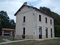 The old railway station, now an activity centre
 -
 The restored wash-house or "Lavoir"
 -
 The west door of the church
 -
 Gilt and polychrome wood altarpiece or retable in the church, made in the 17th century for the Carthusian monastery of Vauclair, Montpon


See also
- Communes of the Dordogne département
References
- ^ "Répertoire national des élus: les maires". data.gouv.fr, Plateforme ouverte des données publiques françaises (in French). 2 December 2020.
- ^ "Populations légales 2021" (in French). The National Institute of Statistics and Economic Studies. 28 December 2023.
- ^ Florence Broussaud-Le Strat, La Double Un pays en Périgord, page 12, Éditions Fanlac, 2006. (in French)
- ^ "Siorac-de-Riberac: Late/Upper Campanian, France". Paleobiology Database. Naturkundemuseum Berlin. Archived from the original on 17 December 2012. Retrieved 14 October 2012.
- ^ The Church of Siorac. Leaflet (English and French), Siorac-de-Ribérac church, 2012.
Sources
- Dignac, Léopold (not dated, printed ca 1960). Monographie de Siorac-de-Ribérac. Imprimerie Périgourdine. (160 pages, octavo, illustrated with monochrome photographs)
| International | |
|---|---|
| National | |
This Dordogne geographical article is a stub. You can help Wikipedia by expanding it. |