
Sioux–Hustler Trail
48°13′45″N 92°09′36″W / 48.2291°N 92.1601°W
The Sioux–Hustler Trail is a 35-mile (56 km) hiking trail in the Boundary Waters Canoe Area in northeastern Minnesota. The trail is approximately an hour's drive from Ely, Minnesota, along the Echo Trail. The trail, which is primitive and not well maintained,[1] runs from the Little Indian Sioux River through relatively untouched country[2] to Hustler Lake, which is at an altitude of 1,302 ft (397 m).[3]
Trail Information
| Distance: | 35 miles round trip |
| Surface: | Native material with uneven tread and exposed roots and rocks |
| Width: | 18" tread, 64" clearance |
| Terrain: | Varied, with hills, exposed ledge rock, wetland areas, a beaver pond, and stream crossings |
| Remarks: | Be prepared with maps, compass, food, water and shelter. Let someone know your plans. This trail is minimally maintained. A permit is required to enter the BWCA Wilderness. Leave No Trace. |
-
 Trail Sign
 -
 Devil's Cascade
 -
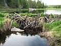 Beaver Dam
 -
 Shell Lake
 -
 Shell Lake 2
 -
 Little Indian Sioux River
 -
 Toilet
 -
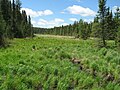 Bog
Bog


References
- ^ "Boundary Waters Canoe Area Wilderness, Sioux-Hustler Trail " Recreation.gov. Retrieved 29 November 2008
- ^ "PRESERVING THE CANOE COUNTRY HERITAGE"[permanent dead link] Friends of the Boundary Waters Wilderness. Retrieved 29 November 2008
- ^ "Hustler Lake Fishing in St. Louis County, Minnesota" fishingworks.com Retrieved 29 November 2008
External links
| Central/Metro | ||
|---|---|---|
| Northeast | ||
| Northwest | ||
| Southeast | ||
| Southwest | ||