
Boundary Waters Canoe Area Wilderness
| Boundary Waters Canoe Area Wilderness | |
|---|---|
wilderness area) | |
 Sunset over Pose Lake, a small lake accessible only by foot. | |
 | |
| Location | Cook, Lake, Saint Louis counties, Minnesota, United States |
| Nearest city | Ely, Minnesota Grand Marais, Minnesota |
| Coordinates | 48°N 91°W / 48°N 91°W |
| Area | 1,090,000 acres (4,400 km2)[1] |
| Established | 1978 |
| Visitors | 105,000 (in 2015) |
| Governing body | U.S. Forest Service |
The Boundary Waters Canoe Area Wilderness (BWCAW or BWCA) comprises 1,090,000 acres (440,000 ha) of pristine forests, glacial lakes, and streams in the Superior National Forest. Located entirely within the U.S. state of Minnesota at the Boundary Waters, the wilderness area is under the administration of the United States Forest Service. Efforts to preserve the primitive landscape began in the 1900s and culminated in the Boundary Waters Canoe Area Wilderness Act of 1978. The area is a popular destination for canoeing, hiking, and fishing, and is the most visited wilderness in the United States.[2]: 10
Geography

The BWCAW extends along 150 miles (240 km) of the Canadian border in the Arrowhead Region of Minnesota. The combined region of the BWCAW, Superior National Forest, Voyageurs National Park, and Ontario's Quetico and La Verendrye provincial parks make up a large area of contiguous wilderness lakes and forests called the "Quetico-Superior country", or simply the Boundary Waters. Lake Superior lies to the south and east of the Boundary Waters.[2][3]: 1–3
Nearly 20% of the BWCAW's total area, or 190,000 acres (77,000 ha), is water. Within the borders of the area are over 1,100 lakes and hundreds of miles of rivers and streams. Much of the other 80% of the area is forest. The BWCAW contains the largest remaining area of uncut forest in the eastern portion of the United States.[2]
The
Located around the perimeter of the BWCAW are six ranger stations: in
Climate
The weather station Ely 25E is on the southern edge of Snowbank Lake (Minnesota), a lake in the Boundary Waters Canoe Area Wilderness. Boundary Waters Canoe Area Wilderness has a dry winter humid continental climate (Köppen Dwb), bordering on a subarctic climate (Köppen Dfc).
| Climate data for Ely 25E, Minnesota, 1991–2020 normals: 1444ft (440m) | |||||||||||||
|---|---|---|---|---|---|---|---|---|---|---|---|---|---|
| Month | Jan | Feb | Mar | Apr | May | Jun | Jul | Aug | Sep | Oct | Nov | Dec | Year |
| Record high °F (°C) | 47 (8) |
62 (17) |
76 (24) |
81 (27) |
94 (34) |
96 (36) |
99 (37) |
97 (36) |
93 (34) |
84 (29) |
72 (22) |
51 (11) |
99 (37) |
| Mean maximum °F (°C) | 36 (2) |
42 (6) |
57 (14) |
71 (22) |
83 (28) |
87 (31) |
91 (33) |
89 (32) |
85 (29) |
72 (22) |
55 (13) |
40 (4) |
92 (33) |
| Mean daily maximum °F (°C) | 15.1 (−9.4) |
20.7 (−6.3) |
34.0 (1.1) |
46.8 (8.2) |
62.1 (16.7) |
72.0 (22.2) |
77.2 (25.1) |
75.1 (23.9) |
65.7 (18.7) |
49.8 (9.9) |
33.2 (0.7) |
20.1 (−6.6) |
47.7 (8.7) |
| Daily mean °F (°C) | 4.2 (−15.4) |
8.4 (−13.1) |
21.4 (−5.9) |
35.5 (1.9) |
50.1 (10.1) |
60.8 (16.0) |
66.0 (18.9) |
63.8 (17.7) |
55.0 (12.8) |
41.0 (5.0) |
26.0 (−3.3) |
11.3 (−11.5) |
37.0 (2.8) |
| Mean daily minimum °F (°C) | −6.7 (−21.5) |
−3.9 (−19.9) |
8.8 (−12.9) |
24.1 (−4.4) |
38.1 (3.4) |
49.7 (9.8) |
54.7 (12.6) |
52.5 (11.4) |
44.3 (6.8) |
32.2 (0.1) |
18.7 (−7.4) |
2.5 (−16.4) |
26.3 (−3.2) |
| Mean minimum °F (°C) | −29 (−34) |
−26 (−32) |
−16 (−27) |
9 (−13) |
27 (−3) |
37 (3) |
46 (8) |
43 (6) |
32 (0) |
22 (−6) |
2 (−17) |
−20 (−29) |
−32 (−36) |
| Record low °F (°C) | −45 (−43) |
−41 (−41) |
−32 (−36) |
−12 (−24) |
22 (−6) |
29 (−2) |
38 (3) |
30 (−1) |
26 (−3) |
5 (−15) |
−16 (−27) |
−39 (−39) |
−45 (−43) |
| Average precipitation inches (mm) | 0.97 (25) |
0.79 (20) |
0.84 (21) |
1.97 (50) |
3.01 (76) |
3.74 (95) |
4.10 (104) |
3.48 (88) |
3.74 (95) |
2.75 (70) |
1.47 (37) |
1.15 (29) |
28.01 (710) |
| Average snowfall inches (cm) | 15.70 (39.9) |
14.10 (35.8) |
7.90 (20.1) |
9.80 (24.9) |
0.40 (1.0) |
0.00 (0.00) |
0.00 (0.00) |
0.00 (0.00) |
0.00 (0.00) |
1.90 (4.8) |
9.90 (25.1) |
17.20 (43.7) |
76.9 (195.3) |
| Source 1: NOAA[6] | |||||||||||||
| Source 2: XMACIS (records & monthly max/mins)[7] | |||||||||||||
Natural history
Geology
The lakes of the BWCAW are located in depressions formed by differential erosion of the tilted layers of the
Many varieties of
Forest ecology
The Boundary Waters area is near the border of the true boreal forest and the

On July 4, 1999, a powerful wind storm, or
The first major wildfire within the blowdown area occurred in August 2005, burning 1,335 acres (540 ha) between Alpine Lake and Seagull Lake in the northeastern BWCAW.

Wildlife
Animals found in the BWCAW include
Woodland caribou once inhabited the region but have disappeared due to encroachment by deer, and the effects of a brainworm parasite carried by deer which is harmful to both caribou and moose populations. Very rare sightings have been reported in nearby areas as recently as the 1980s.[26]
Human history
Native Americans

The north country was inhabited by the Paleo Indian culture circa 8000 BC. Limited artifacts have been found in the BWCAW from that era and the subsequent Archaic period circa 6000 years ago. Artifacts from the Early Woodland Era (circa 1300 years ago) have not been found there, but pottery and clay pipes from the Later Woodland Indians have been found there.[27]
The area was then sparsely populated by the
European exploration and development

In 1688 the French explorer Jacques de Noyon became the first European known to have traveled through the BWCAW area. Later, during the 1730s, La Vérendrye and others opened the region to trade, mainly in beaver pelts. By the end of the 18th century, the fur trade had been organized into groups of canoe-paddling voyageurs working for the competing North West and Hudson's Bay Companies, with a North West Company fort located at the Grand Portage on Lake Superior. The final rendezvous was held at Grand Portage in 1803, after which the North West Company moved its operations further north to Fort William (now Thunder Bay). In 1821 the North West Company merged with the Hudson's Bay Company and the center of the fur trade moved even further north to the posts around Hudson Bay.[3]: 5–8 [29]
During the late 18th and early 19th centuries, the area's legal and political status was disputed. The Treaty of Paris, which ended the American Revolutionary War in 1783, had defined the northern border between the United States and Canada based on the inaccurate Mitchell Map. Ownership of the area between Lake of the Woods and Lake Superior was unclear, with the United States claiming the border was further north at the Kaministiquia River and Canada claiming it was further south beginning at the Saint Louis River.[30] In 1842, the Webster–Ashburton Treaty clarified the border between the United States and Canada using the old trading route running along the Pigeon River and Rainy River (today the BWCAW's northern border).[3]: 8–9
The BWCAW area remained largely undeveloped until gold, silver and iron were found in the surrounding area during the 1870s, 1880s and 1890s. Logging in the area began around the same time to supply lumber to support the mining industries, with production peaking in the late 1910s and gradually trailing off during the 1920s and 1930s.[3]: 9–12
Protection
In 1902, Minnesota's Forest Commissioner
The BWCAW itself was formed gradually through a series of actions. By the early 1920s, roads had begun to be built through the Superior National Forest to promote public access to the area for recreation. In 1926 a section of 640,000 acres (260,000 ha) within the Superior National Forest was set aside as a roadless wilderness area by Secretary of Agriculture William Marion Jardine. This area became the nucleus of the BWCAW. In 1930, Congress passed the Shipstead-Newton-Nolan Act, which prohibited logging and dams within the area to preserve its natural water levels. Through additional land purchases and shifts in boundaries, the amount of protected land owned by the government in the area grew even further. In 1938, the area's borders were expanded and altered (roughly matching those of the present day BWCAW), and it was renamed the Superior Roadless Primitive Area.[31][32]
Additional laws focused on protecting the area's rustic and undeveloped character. In 1948, the Thye-Blatnik Bill authorized the government to purchase the few remaining privately owned homes and resorts within the area. In 1949, President
Land use disputes
Some aspects of the BWCAW's management and conservation have been controversial. A 1971 rule limiting visitors to "designated campsites" on heavy-use routes is instituted by the U.S. Forest Service. Cans and glass bottles are prohibited from the Boundary Waters. According to the U.S. Forest Service, the measure is expected to reduce refuse by 360,000 pounds (160 t), saving $90,000 per year on cleanup.
October 1975, Eighth District Representative
October 21, 1978, Boundary Waters Canoe Area Wilderness Act, U.S. Public Law 95-495, was signed by
1989 Truck portage testing. According to the 1978 BWCAW Act: Nothing in this Act shall be deemed to require the termination of the existing operation of motor vehicles to assist in the transport of boats across the portages from Sucker Lake to Basswood Lake, from Fall Lake to Basswood Lake, and from Lake Vermilion to Trout Lake, during the period ending January 1, 1984. Following said date, unless the Secretary determines that there is no feasible non-motorized means of transporting boats across the portages to reach the lakes previously served by the portages listed above, he shall terminate all such motorized use of each portage listed above.
1989 – U S Forest Service with the University of MN conduct feasibility tests on the three truck portages. It is determined that trucks should remain.
1990 – Friends of the Boundary Waters, Sierra Club and six other environmental groups sue to have trucks removed; CWCS joins the U S Forest Service as intervenors.
1992 – Appeals court sides with U S Forest Service that trucks should remain. Friends of the Boundary Waters and coalition appeal to
1994 – As a result of the Friends of the Boundary Waters lawsuit against the 1992 BWCAW Management Plan, canoe rests, pontoon boats and sailboats are banned from the Boundary Waters.
1999 – As a result of the Friends of the Boundary Waters lawsuit against the 1992 BWCAW Management Plan, the courts redefined the phrase ‘that particular lake’ and exempt permits were eliminated for property owners, resorts and outfitters on the Moose, Farm and Seagull Chain of Lakes.
1999 – Trucks return to two of the three truck portages, Prairie and Trout Lake portages, as a result of Congressman Oberstar including this provision in his 1998 Transportation Bill.
A snowmobile trail located 400 feet (120 m) from the border provoked a lawsuit in 2006. In 2015, a judge ruled that the snowmobile trail did not violate the Wilderness Act.[34][35]
Proposed Twin Metals Mine
It has been known for decades that there are about four billion tons of copper and nickel ore, "one of the world's largest undeveloped mineral deposits", in the
Recreation

The BWCAW attracts over 150,000 visitors per year.
Permits are required for all overnight visits to the BWCAW. Quota permits are required for groups taking an overnight paddle, motor, or hiking trip, or a motorized day-use trip into the BWCAW from May 1 through September 30. These permits must be reserved in advance. Day use paddle and hiking permits do not require advance reservation and can be filled out at BWCAW entry points. From October 1 through April 30, permit reservations are not necessary, but a permit must be filled out at the permit stations located at each entry point. Each permit must specify the trip leader, the specific entry point and the day of entry. The permits are for an indefinite length, although visitors are only allowed one entry into the wilderness and cannot stay in one campsite for more than 14 nights.[2]
Hiking

The BWCAW contains a variety of hiking trails. Shorter hikes include the trail to
Canoeing
Canoeing or other non-motorized boating is the most popular method of exploring the BWCAW. A 2007 study found more than 94% of overnight visitors used a non-motorized boat to travel through the park.[46] The BWCAW's size and abundance of campsites, lakes, rivers and portage trails allow for almost countless options for different routes. Many online maps and guidebooks offer suggested routes based on entry point, duration and difficulty.[47][48][49]
-
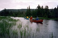 Canoe campers on a trip in the BWCAW
 -
 A BWCA paddler with her wood-and-canvas canoe


Fishing
Fishing is a popular activity in the BWCAW. Game species include northern pike, walleye, largemouth bass, smallmouth bass, and occasional panfish. Trout including brook trout, lake trout, rainbow trout and splake are also found. White sucker, burbot, and whitefish also occur. Limited stocking of walleye and lake trout is done on some lakes where natural recruitment is limited.[2] The wilderness contains one of the largest concentrations of native lake trout lakes in the lower 48 states.
Night sky viewing
In 2020 the BWCA became a designated Dark Sky Sanctuary, one of 15 in the world.[50] "It differs from other Dark Sky designations in that sanctuaries are the most remote and often darkest places in the world whose conservation state is 'most fragile'."[51] The U.S. Forest Service had been working towards gaining this status for the BWCAW since 2008. According to the US forest service "This designation confirms what people in the area have enjoyed for thousands of years. Dark skies, starry nights, and astonishing northern lights displays have been part of the experience long before the area was designated wilderness..."[51]
Notable people associated with the BWCAW
- Benny Ambrose, one of the last two residents of BWCAW.[52]
- Justine Kerfoot, local author and renowned outdoorswoman who moved to the Boundary Waters in 1928 and helped establish the Gunflint Lodge.[53][54]
- Dorothy Molter, known as the "Rootbeer Lady", lived in the BWCAW for 56 years (alone after 1948) until her death in 1986, and was the last resident of the BWCA.
- Ernest Oberholtzer, is recognized today as a leading advocate for the preservation of the Quetico-Superior lake area and what would become the BWCA.
- Sigurd Olson, Minnesota author and conservationist, wrote extensively about the Boundary Waters and worked to ensure preservation of the wilderness.
References
- ^ "Land Area Report". U.S. Forest Service. 2004. Retrieved August 28, 2006.
- ^ a b c d e f g h "Boundary Waters Canoe Area Wilderness Trip Planning Guide" (PDF). USDA – Forest Service.
- ^ ISBN 0-87351-116-6.
- ^ ISBN 978-0-7627-1148-2.
- S2CID 162310609. (Abstract)
- ^ "Ely 25E, Minnesota 1991-2020 Monthly Normals". Retrieved October 30, 2023.
- ^ "xmACIS". National Oceanic and Atmospheric Administration. Retrieved October 30, 2023.
- ^ ISBN 0-8166-0953-5.
- ^ ISBN 0-8166-2804-1.
- ^ Weiblen, Paul W. (1971). "It's Written in the Rocks: The BWCA History" (PDF). The Conservation Volunteer.
- PMID 17783259.
- ^ Heinselman (1996), p. 18, Table 4.1. This figure is for solid contiguous areas of virgin forest; it does not include some smaller areas within cut-over forests, nor some shoreline areas of virgin woods. Id.
- ^ "ECS: Border Lakes Subsection". Minnesota Department of Natural Resources.
- ^ "10 years after the big blowdown". Friends of the Boundary Waters Wilderness. Archived from the original on April 16, 2016. Retrieved November 12, 2015.
- ^ "Alpine Lake Fire". bwca.cc.
- ^ "BWCA Cavity Lake Wildfire". bwca.cc.
- ^ "Turtle Lake Fire". bwca.cc.
- ^ "Gunflint Trail fire anniversary to be marked by tree plantings". KARE11.com. KARE-TV.[dead link]
- ^ Etten, Douglas (September 13, 2011). "Boundary Waters fire threatening homes, cabins". Lakeland Times. Archived from the original on September 30, 2011. Retrieved September 13, 2011.
- ^ Gabbert, Bill. "Smoke from Pagami Creek fire detected over eastern Europe today". Wildfire Today.
- CTV Toronto. September 13, 2011. Retrieved September 13, 2011.
- ^ "Smoke from Minnesota forest fire makes its way to Chicago's suburbs". Chicago Tribune. September 13, 2011. Retrieved September 13, 2011.
- ^ Hollingsworth, Jana (August 23, 2021). "Minnesota's largest wildfire likened to a 'freight train' as it grows, spurs more evacuations". Star Tribune. Archived from the original on August 24, 2021. Retrieved August 24, 2021.
- ^ "Inciweb map". August 24, 2021. Showing Whelp and John Ek fires.
- ^ "Superior National Forest – About the Forest". USDA – Forest Service.
- JSTOR 2425312.
- ^ Monthei, Heather (Spring 2020). "Paddling Down BWCAW History". Boundary Waters Journal. pp. 48–57.
- ISBN 978-0-916691-02-8.
- ^ Morse, Eric W. (1969). Fur Trade Canoe Routes of Canada/Then and Now (PDF). Ottawa: Queen's Printer and Controller of Stationery.
- ISBN 0-87351-153-0.
- ^ a b "History of the BWCAW". United States Forest Service.
- ^ a b Wilbers, Stephen. "Boundary Waters Chronology". Retrieved September 27, 2009.
- ^ "Heritage History: BWCAW timeline". Superior National Forest, United States Forest Service.
- ^ Kelleher, Bob. "The Boundary Waters: 25 years later". Minnesota Public Radio.
- ^ Furst, Randy (February 14, 2015). "Judge rules in favor of proposed snowmobile route bordering BWCA". Minneapolis Star-Tribune.
- ISBN 0-8166-0953-5.
- ^ "Minnesota's Vast Mineral Resources". Mining Minnesota. Retrieved July 3, 2019.
- ^ ISSN 0362-4331. Retrieved June 25, 2019.
- ^ Hemphill, Stephanie (June 23, 2010). "At the edge of the Boundary Waters, miners probe for copper, nickel". Minnesota Public Radio. Archived from the original on June 26, 2019.
- ^ Kraker, Dan (September 7, 2018). "Feds reopen forests near Boundary Waters to mining". Minnesota Public Radio.
- ^ Karnowski, Steve. "Biden Administration Delivers Serious Blow to Minnesota Mine". U.S.News & World Report. Retrieved December 5, 2021.
- ^ "Boundary Waters Canoe Area Wilderness Permit and Visitor Use Trends 2009-2016" (PDF).
- ^ "BWCA Trails". CanoeCountry.com.
- ^ "Border Route Trail Association". North Country Trail Association.
- ^ "Kekekabic Trail Chapter". North Country Trail Association.
- ^ Dvorak, Robert G.; Watson, Alan E.; Christensen, Neal; Borrie, William T.; Schwaller, Ann. "The Boundary Waters Canoe Area Wilderness: Examining Changes in Use, Users, and Management Challenges" (PDF). United States Department of Agriculture – Forest Service. p. 11.
- ISBN 978-1-4529-0646-1.
- ISBN 978-0-89997-610-5.
- ISBN 978-0-89997-461-3.
- ^ "International Dark Sky Sanctuaries". International Dark-Sky Association. Retrieved March 1, 2022.
- ^ a b Johnson, Allie (September 10, 2020). "Boundary Waters Canoe Area Wilderness becomes International Dark Sky Sanctuary". Fox9. KMSP. Retrieved October 12, 2020.
- ^ "Wilderness man dead at 82". United Press International. Retrieved October 31, 2023.
- ^ "City Girl Justine Kerfoot became a North Woods Icon". Star Tribune. Minneapolis. May 5, 2019.
- ^ Minnesota Historical Society. "Minnesota Environmental Issues Oral History Project: Interview with Justine Kerfoot". Minnesota Historical Society. Retrieved June 19, 2020.
Further reading
- Fox, Porter (October 21, 2016). "On the Water, and into the Wild". The New York Times. p. 1.
- Proescholdt, Kevin; Rapson, Rip; Heinselman, Miron L. (1995). Troubled Waters. St. cloud, Minnesota: North Star Press of St. Cloud. ISBN 0-87839-100-2.