
Sorpe Dam
This article includes a list of general references, but it lacks sufficient corresponding inline citations. (March 2022) |
| Sorpe Dam | |
|---|---|
MW |
The Sorpe Dam (
Together with the Biggesee, the Möhne Reservoir, and the Verse reservoir, the Sorpe Reservoir is one of the major artificial lakes of the Sauerland's Ruhrverband reservoir association. It serves as a water supply, drives hydroelectric generators, and is used for leisure and recreation.
Geography

The Sorpe Dam is situated to the north of the Homert natural park, south-west of the city of Arnsberg in an area belonging to the borough of Sundern (Sauerland) between the villages of Langscheid (at the dam) and Amecke. It is supplied by the Sorpe stream.
About once a year in spring, the reservoir runs over into the spillway, generating massive whitewater down the cascades to the stilling basin that draws crowds of spectators for a few days.
Neighbouring municipalities
History
The major prerequisite for the construction of the Sorpe Dam was the completion of the Röhrtal railway on 1 June 1900, a
In
After the war, in late 1958 the reservoir was drained for bomb damage repairs, in the course of which, shortly before Christmas, workers discovered an unexploded Tallboy bomb. On 6 January 1959 the whole village of Langscheid was evacuated while Northrhine-Westphalia's chief bomb disposal officer, Walter Mietzke, and British Lieutenant, James M. Waters, jointly defused the 3.6m long bomb that still contained 2.5 metric tonnes of high explosive and 3 highly unstable tail-fuzes.[1]
Recreation
Today, the Sorpe Reservoir affords opportunities to several recreational activities like
The campsites are numbered 2 through 5 from North to South; the youth hostel was built at the location of former campsite 1.
A new bicycle and pedestrian lane was constructed on the west bank parallel to the quayside road in 2006, connecting the hamlets of Sundern-Amecke and Sundern-Langscheid. Motor access to the east bank road is limited to service vehicles. Private motor boats are prohibited on the reservoir to prevent oil spills and for maintaining a high drinking water quality.
Image gallery
This section contains an unencyclopedic or excessive gallery of images. |
-
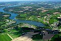 View of the reservoir looking north, foreground: Amecke, background: Langscheid
 -
 View of the dam from one of the campsites on the West bank
 -
 View of the dam from one of the campsites on the West bank
 -
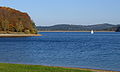
 View from the West bank looking South
 -
 View of the dam from the West bank
 -
 Stilling basin
 -
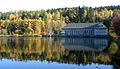
 Stilling basin, hydroelectric power station and dam
 -
 Stilling basin and hydroelectric power station
 -
 Stilling basin
 -
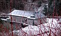
 Sorpe dam seen from Langscheid look-out tower in winter
 -
 Spillway
 -
 Spillway cascades
 -
 Stilling basin
 -
 Hydroelectric power station seen from top of dam


See also
- Röhr river
- Dams in North Rhine-Westphalia
- List of reservoirs and dams in Germany
References
- ^ w.e. "Der größte Blindgänger wird heute entschärft" (PDF). abendblatt.de. Archived from the original (PDF) on 14 July 2014. Retrieved 8 July 2014.
External links
- Sorpesee.de—(in German)
- Ruhrverband data page (in German)
- Register of reservoirs and dams in Northrhine-Westphalia (in German)
- Private collection of pictures from the early days of the dam, Sorpe valley prior and during dam construction, and Langscheid life and architecture in the first half of the 20th century Archived 4 July 2017 at the Wayback Machine
- Original newspaper page in pdf format with picture of the dud[permanent dead link] (in German)
- Private collection of pictures related to the airstrikes Archived 23 October 2019 at the Wayback Machine (in German)