Spectrum Range
| Spectrum Range | |
|---|---|
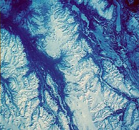
 Satellite photo of the Spectrum Range | |
| Highest point | |
| Peak | Kitsu Peak |
| Elevation | 2,414 m (7,920 ft) |
| Coordinates | 57°26′0″N 130°41′0″W / 57.43333°N 130.68333°W |
| Geography | |
| Country | Canada |
| Province | British Columbia |
| Parent range | Tahltan Highland (southwestern Stikine Plateau) |
| Geology | |
| Orogeny | Volcanism |
| Age of rock | Pliocene-to-Holocene |
| Type of rock | Shield volcano |
The Spectrum Range, formerly called the Spectrum Mountains and the Rainbow Mountains, is a
Stewart-Cassiar Highway, south of Mount Edziza and north of the Arctic Lake Plateau. The Spectrum Range falls within Mount Edziza Provincial Park. The range is lightly glaciated, as compared to the other ranges to the west. It is accessible only by foot or via helicopter; there are no roads to the range.[1]
Geology
Like the
Rainbow and Itcha–Ilgachuz Ranges at the western end of the Chilcotin Plateau farther south, the range's name derives from the brilliant colours that are symptomatic from heavy mineralization comprising the material forming the range.[1]
The Spectrum Range is one of four large
.Mountains
- Artifact Ridge
- Kitsu Peak
- Kounugu Mountain
- Kuno Peak
- Little Iskut
- Obsidian Ridge
- Spectrum Dome
- Yagi Ridge
- Yeda Peak
See also
- List of volcanoes in Canada
- List of Northern Cordilleran volcanoes
- List of mountain ranges
- Volcanism of Canada
- Volcanism of Western Canada
- Rainbow Range (Chilcotin Plateau) (aka Rainbow Mountains)
References
- ^ ISBN 0-89577-087-3.
External links
-
Spectrum Range colours from heavy mineralization


