
Springer Mountain
| Springer Mountain | |
|---|---|
East Ellijay | |
| Highest point | |
| Elevation | 3,782 ft (1,153 m) NAVD 88[1] |
| Prominence | 1142 |
| Coordinates | 34°37′36″N 84°11′37″W / 34.62667°N 84.19361°W |
| Geography | |
 Springer Mountain Location of Springer Mountain in Georgia | |
| Location | |
| Parent range | Blue Ridge Mountains |
| Topo map | USGS Noontootla |
| Climbing | |
| First ascent | unknown |
| Easiest route | Appalachian Trail |
Springer Mountain is a mountain located in the
Name
The origin of the name of Springer Mountain is unclear. One possible origin was that it was named in honor of William G. Springer, an early settler appointed in 1833 by Governor Wilson Lumpkin to implement legislation to improve conditions for the Indians. Another possibility was that Springer Mountain was named for the first Presbyterian minister to be ordained in Georgia, John Springer, who was ordained in 1790.[2]
The mountain has been called Springer since at least 1910. As late as 1959, some residents of Gilmer County were still calling the peak Penitentiary Mountain. According to the Gilmer County Historical Society, the name was officially changed by the Georgia Appalachian Trail Club (GATC). It is unknown why the mountain was named Penitentiary.[3] There is no known Cherokee name for the mountain.[4]
Geography
Springer Mountain is a north–south-trending
The mountain is located about 17 miles (27 km) east of Ellijay, 14 miles (23 km) northwest of Dahlonega and 11 miles (18 km) southwest of Suches.[5] Mount Oglethorpe, the original southern terminus of the Appalachian Trail, is located about 14 miles (23 km) south of Springer Mountain.[3] Other nearby geographical features include Black Mountain, Tickanetley Creek and Winding Stair Gap.[5]
Hiking
Appalachian Trail

In 1958, the southern terminus of the Appalachian Trail was relocated from Mount Oglethorpe to Springer Mountain. The reason for this relocation was because of increased development around Mount Oglethorpe.[7] Springer Mountain was considered to be less dramatic than Mount Oglethorpe, but because of its remoteness, Springer Mountain was also considered to be less susceptible to development.[4]
One way to climb Springer Mountain is from a parking lot on Forest Service Road 42, located 0.9 miles (1.4 km) north up the Appalachian Trail from the summit. Hikers desiring to hike north from Springer Mountain would begin by hiking 0.9 miles (1.4 km) south on the Appalachian Trail before turning around to hike north. At the peak of Springer Mountain is a bronze plaque with the Appalachian Trail logo, a register for hikers to sign, and a benchmark.[8]
In addition to the Appalachian Trail, Springer Mountain can be reached from the south via the Appalachian Approach Trail.[9] The approach trail starts at the visitor's center of Amicalola Falls State Park and is 8.5 miles (13.7 km) in length.[8]
Benton MacKaye Trail
Springer Mountain is also home to the southern terminus of the Benton MacKaye Trail. The trailhead for the Benton MacKaye Trail is located around 0.3 miles (0.48 km) north of the summit.[10][11][12]
Shelters
The nearest shelter from the summit is the Springer Mountain Shelter, located about 0.2 miles (0.32 km) north of the summit. A water spring is located near this shelter.[13][14] Another nearby shelter is the Black Gap Shelter, located about 1.5 miles (2.4 km) south of the summit on the Appalachian Approach Trail.[9]
Gallery
-
 A hiker signs the Appalachian Trail register at Springer Mountain
 -
 Appalachian Trail marker
 -
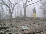
 Campsite on top of the mountain
 -
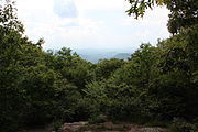 View from Springer Mountain in May
 -
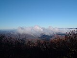 View from Springer Mountain in November
 -
 Springer Mountain (left) and Black Mountain (right) covered in snow. Viewed from East Ellijay


.jpg)


.jpg)
See also
- List of mountain peaks of North America
- List of mountain peaks of the United States
- List of U.S. states by elevation
- List of mountains in Georgia (U.S. state)
- List of mountain peaks of the United States
- List of peaks on Appalachian Trail in Georgia
References
- ^ a b c "Springer Mountain, Georgia". Peakbagger.com.
- ISBN 0-915430-00-2.
- ^ a b c d Logue, Victoria. The Story Behind Springer. 1990. Retrieved 26 May 2016.
- ^ ISBN 9780811730952.
- ^ a b c United States Geological Survey (26 May 2016). Noontootla, GA quadrangle (Topographic map). Reston, VA: United States Geological Survey. Retrieved 26 May 2016 – via TopoQuest.
- ^ "Map of the Blue Ridge District, Chattahoochee National Forest" (PDF). U.S. Forest Service. Retrieved 30 April 2012.
- ISBN 978-0738591032. pp. 11.
- ^ a b Springer Mountain Trailhead. usda.gov. Retrieved 26 May 2016.
- ^ a b AT Approach Trail: Hiking Amicalola Falls to Springer Mountain. atlantatrails.com. Retrieved 25 May 2016.
- ^ Benton MacKaye, Sec. I. georgiatrails.com. 24 January 2016. Retrieved 26 May 2016.
- ^ Champlin, Eric. Springer Mountain Loop Trail: Hiking the Appalachian Trail & BMT. atlantatrails.com. Retrieved 26 May 2016.
- ISBN 1889596264. pp. 155.
- ^ AT Springer Mountain to Woody Gap. 14 September 2013. Retrieved 26 May 2016.
- ^ Trail Guide. Georgia Appalachian Trail Club. Retrieved 26 May 2016.
External links
- Georgia AT club
- Springer Mountain Hiking & Backpacking Trails
- TopoQuest Map of Springer Mountain
- "Springer Mountain". Peakware.com. Archived from the original on 2016-03-04.