
St. Cloud, Wisconsin
St. Cloud, Wisconsin | ||
|---|---|---|
FIPS code 55-70500[5] | | |
| GNIS feature ID | 1572903[2] | |
| Website | www | |
St. Cloud is a village in
History
A post office called St. Cloud has been in operation since 1867.[7] The village was named after Saint-Cloud, in France.[8]
Geography
St. Cloud is located at 43°49′N 88°10′W / 43.817°N 88.167°W (43.822, -88.167), in the Town of Marshfield (§25 T16N R19E).[9]
According to the United States Census Bureau, the village has a total area of 0.94 square miles (2.43 km2), of which, 0.92 square miles (2.38 km2) of it is land and 0.02 square miles (0.05 km2) is water.[10]
Demographics
| Census | Pop. | Note | %± |
|---|---|---|---|
| 1880 | 183 | — | |
| 1910 | 309 | — | |
| 1920 | 367 | 18.8% | |
| 1930 | 365 | −0.5% | |
| 1940 | 353 | −3.3% | |
| 1950 | 408 | 15.6% | |
| 1960 | 530 | 29.9% | |
| 1970 | 550 | 3.8% | |
| 1980 | 560 | 1.8% | |
| 1990 | 494 | −11.8% | |
| 2000 | 497 | 0.6% | |
| 2010 | 477 | −4.0% | |
| 2019 (est.) | 466 | [4] | −2.3% |
| U.S. Decennial Census[11] | |||
2010 census
As of the
There were 208 households, of which 26.0% had children under the age of 18 living with them, 58.7% were married couples living together, 5.8% had a female householder with no husband present, 4.3% had a male householder with no wife present, and 31.3% were non-families. 26.9% of all households were made up of individuals, and 13% had someone living alone who was 65 years of age or older. The average household size was 2.29 and the average family size was 2.76.
The median age in the village was 43.3 years. 20.3% of residents were under the age of 18; 5.1% were between the ages of 18 and 24; 28.5% were from 25 to 44; 29.8% were from 45 to 64; and 16.4% were 65 years of age or older. The gender makeup of the village was 48.6% male and 51.4% female.
2000 census
As of the
There were 184 households, out of which 34.8% had children under the age of 18 living with them, 63.6% were married couples living together, 4.9% had a female householder with no husband present, and 29.3% were non-families. 22.3% of all households were made up of individuals, and 13.0% had someone living alone who was 65 years of age or older. The average household size was 2.70 and the average family size was 3.25.
In the village, the population was spread out, with 27.0% under the age of 18, 9.5% from 18 to 24, 29.0% from 25 to 44, 19.3% from 45 to 64, and 15.3% who were 65 years of age or older. The median age was 36 years. For every 100 females, there were 91.2 males. For every 100 females age 18 and over, there were 97.3 males.
The median income for a household in the village was $51,964, and the median income for a family was $56,625. Males had a median income of $36,563 versus $21,618 for females. The
Notable people
- D. C. Coolidge, Wisconsin State Representative, was born in St. Cloud.[12]
- Robert W. Monk, Wisconsin State Senator, lived in St. Cloud.[13]
- Ty Bodden, Wisconsin State Representative, lived in St. Cloud multiple times.
Images
-
 Village hall and fire station
 -
 Roman Catholicchurch
 -
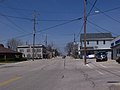 Looking north at downtown St. Cloud
 -
 Looking north at downtown St. Cloud
 -
 St. Cloud Post Office
 -
 Water tower


References
- ^ "2019 U.S. Gazetteer Files". United States Census Bureau. Retrieved August 7, 2020.
- ^ a b "US Board on Geographic Names". United States Geological Survey. October 25, 2007. Retrieved January 31, 2008.
- ^ a b "U.S. Census website". United States Census Bureau. Retrieved November 18, 2012.
- ^ a b "Population and Housing Unit Estimates". United States Census Bureau. May 24, 2020. Retrieved May 27, 2020.
- ^ a b "U.S. Census website". United States Census Bureau. Retrieved January 31, 2008.
- ^ "Archdiocese of Milwaukee - Parish Details - St. Cloud". Archived from the original on August 15, 2009. Retrieved October 6, 2008.
- ^ "Fond du Lac County". Jim Forte Postal History. Retrieved March 28, 2015.
- ^ Chicago and North Western Railway Company (1908). A History of the Origin of the Place Names Connected with the Chicago & North Western and Chicago, St. Paul, Minneapolis & Omaha Railways. p. 121.
- ^ "US Gazetteer files: 2010, 2000, and 1990". United States Census Bureau. February 12, 2011. Retrieved April 23, 2011.
- ^ "US Gazetteer files 2010". United States Census Bureau. Archived from the original on January 25, 2012. Retrieved November 18, 2012.
- ^ "Census of Population and Housing". Census.gov. Retrieved June 4, 2015.
- ^ THE BLUE BOOK OF THE STATE OF WISCONSIN. Madison, Wis. 1909. pp. 1116–1117.
{{cite book}}: CS1 maint: location missing publisher (link) - ^ 'Wisconsin Blue Book 1915,' Biographical Sketch of Robert W. Monk, pg. 497
External links
 | ||||
Villages | ||||
Towns | ||||
| CDPs | ||||
| Other communities |
| |||
| Former communities | ||||
| Footnotes | ‡This populated place also has portions in an adjacent county or counties | |||
| ||||