
Stephensville, Wisconsin
This article needs additional citations for verification. (January 2023) |
Stephensville, Wisconsin | |
|---|---|
920 |
Stephensville is a small unincorporated community located entirely within the town of Ellington in west-central Outagamie County, Wisconsin, United States. Stephensville is classified as a Class U6 Community by the USGS, being a populated place located wholly or substantially outside the boundaries of any incorporated place or CDP with a recognized authoritative common name.[1]
Stephensville is located 4 miles northeast of Hortonville, 7 miles northwest of Greenville, 5 miles south of Shiocton and 15 miles northwest of Appleton.
Bear Creek passes through the community just east of its mouth with the
Mail is delivered by the Hortonville post office.
Geography
Stephensville is located at 44°22′24″N 88°35′3″W / 44.37333°N 88.58417°W (44.3733170, -88.5842708), and the elevation is 804 feet (245 m).[1]
Education
Stephensville is located within the Hortonville Area School District.
Transportation
Stephensville is located on
Worship
Saint Patrick Catholic Church and Saint Paul Evangelical Lutheran Church are located within the community.
Images
-
 Looking south at Stephensville
 -
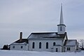 Catholic Church
 -
 Looking south at downtown Stephensville


References
External links
 | ||||
Villages | ||||
Towns | ||||
| CDP | ||||
| Other communities | ||||
| Indian reservation | ||||
| Former communities | ||||
| Footnotes | ‡This populated place also has portions in an adjacent county or counties | |||
| ||||
This article about a location in Outagamie County, Wisconsin is a stub. You can help Wikipedia by expanding it. |