Stepney, Connecticut
Stepney, Connecticut | |
|---|---|
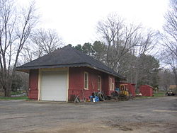
 Former Stepney railroad station | |
|
UTC-4:00 (Eastern) | |
| Area code(s) | 203 |
Stepney, also referred to as Stepney Village and Upper Stepney, is a district of the town of
Route 25, to the Newtown town line. It was listed as a census-designated place prior to the 2020 census.[1]
First settled around 1720, Stepney was originally a productive farming community made up of transplants from settlements to the south such as
Bridgeport and Newtown Turnpike
, the first paved road in the town of Monroe, and along Hattertown Road.
Once a depot for the
Stepney Volunteer Fire Department
, today Stepney is home to over a dozen historic buildings dating from before the 20th century, and is predominantly a suburban community with the majority of its business located along the Route 25 corridor.

