
Old Greenwich, Connecticut
Old Greenwich | ||
|---|---|---|
GNIS feature ID2631571 | | |
Old Greenwich is an affluent coastal village in
The town of Greenwich is one political and taxing body, but consists of several distinct sections or neighborhoods, such as
History
This section needs additional citations for verification. (February 2020) |
One of the founding settlers of Old Greenwich was Elizabeth Fones,[4] niece and daughter-in-law of John Winthrop, founder and Governor of the Massachusetts Bay Colony. What is now called Greenwich Point was known for much of its early history as "Elizabeth Neck" in recognition of Elizabeth (Fones) Feake Hallet and her 1640 purchase of the Point and much of the area now known as Old Greenwich.[5]
The
Old Greenwich was known as "Sound Beach" in the 19th century for its proximity to Long Island Sound, and the main road through the small downtown business section is Sound Beach Avenue.
Old Greenwich had an industrial presence in the 1950s and 1960s when
The town of Greenwich has one political body (RTM – Representative Town Meeting). It has several distinct sections each with its own mailing address and
Geography
According to the U.S. Census Bureau, Old Greenwich has a total area of 3.48 mi2 (9.01 km2), of which 2.00 mi2 (5.17 km2) is land and 1.48 mi2 (3.84 km2), or 42.5%, is water.[8]
Education
As with other parts of the Town of Greenwich, Old Greenwich is in the Greenwich Public Schools school district.[9] The district's comprehensive high school is Greenwich High School.
Notable people
- Edwin Binney
- Ruth Madoff, wife of Bernie Madoff
- Tim Mazzetti
- Mike Sandlock
- Jack Trout
- Edward Vick
- Constance Walton
- Victor Borge
Gallery
-
 Sound Beach Avenue, east side
 -
 Old Greenwich Railroad Station
 -
 Arch Street tunnel under the railroad tracks
 -
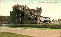 "The Castle," circa 1908


See also
References
- ^ Warren, Katie. "People aren't buying the iconic, sprawling mansions in one of America's richest cities, a haven for Wall Street types an hour from NYC. I spent a day there — here's what it was like". Business Insider. Retrieved June 30, 2020.
- ^ U.S. Geological Survey Geographic Names Information System: Old Greenwich, Connecticut
- ^ "Race, Hispanic or Latino, Age, and Housing Occupancy: 2010 Census Redistricting Data (Public Law 94-171) Summary File (QT-PL), Old Greenwich CDP, Connecticut". United States Census Bureau. Retrieved August 11, 2011.
- ^ Mead, Spencer P. Ye Historie of Ye Town of Greenwich (New York: Knickerbocker Press, 1911), pp 4-9
- ^ "Friendsofgreenwichpoint.org - Greenwich Point History". Archived from the original on November 17, 2012. Retrieved November 21, 2012.
- ^ Merchant, Robert. "Effort afoot to restore Condé Nast pillars in Old Greenwich". Greenwich Time. Hearts CT Media. Retrieved January 22, 2022.
- ^ "Condé Nast Publications, Inc. History". Funding Universe. Retrieved January 22, 2022.
- ^ "US Gazetteer files: 2019". United States Census Bureau. Retrieved July 19, 2020.
- U.S. Census Bureau. Retrieved May 25, 2024.

| International | |
|---|---|
| National | |
| Geographic | |