
Sunset, Louisiana
Sunset, Louisiana | |
|---|---|
Town | |
| Town of Sunset | |
CDT) | |
| Area code | 337 |
| FIPS code | 22-74060 |
| Website | www.sunset.govoffice2.com |
| [2] | |
Sunset is a
Geography
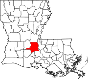
Sunset is located at 30°24′30″N 92°3′58″W / 30.40833°N 92.06611°W (30.408456, -92.066132).[3]
According to the United States Census Bureau, the town has a total area of 3.1 square miles (8.1 km2), of which 3.1 square miles (8.1 km2) is land and 0.04 square mile (0.1 km2) (0.96%) is water.
Demographics
| Census | Pop. | Note | %± |
|---|---|---|---|
| 1910 | 377 | — | |
| 1920 | 433 | 14.9% | |
| 1930 | 520 | 20.1% | |
| 1940 | 630 | 21.2% | |
| 1950 | 1,080 | 71.4% | |
| 1960 | 1,307 | 21.0% | |
| 1970 | 1,675 | 28.2% | |
| 1980 | 2,300 | 37.3% | |
| 1990 | 2,201 | −4.3% | |
| 2000 | 2,352 | 6.9% | |
| 2010 | 2,897 | 23.2% | |
| 2020 | 2,909 | 0.4% | |
| U.S. Decennial Census[4] | |||
2020 census
| Race | Number | Percentage |
|---|---|---|
White (non-Hispanic)
|
1,324 | 45.51% |
Black or African American (non-Hispanic)
|
1,426 | 49.02% |
Native American
|
6 | 0.21% |
Asian
|
7 | 0.24% |
Other/Mixed
|
89 | 3.06% |
Latino
|
57 | 1.96% |
As of the 2020 United States census, there were 2,909 people, 1,063 households, and 796 families residing in the town.
2010 census
As of the
There were 1,129 households, out of which 38.0% had children under the age of 18 living with them, 41.4% were married couples living together, 23.6% had a female householder with no husband present, and 30.3% were non-families. 25.8% of all households were made up of individuals, and 19.0% had someone living alone who was 65 years of age or older. The average household size was 2.57 and the average family size was 3.09.
In the town, the population was spread out, with 31.4% under the age of 18, 6.4% from 20 to 24, 25.1% from 25 to 44, 27.8% from 45 to 64, and 9.4% who were 65 years of age or older. The median age was 34.7 years. For every 100 females, there were 87.3 males. For every 100 females age 18 and over, there were 86.2 males.
As of the 2009
History
Like many towns in Southern Louisiana, Sunset began as a railroad town (for the out-distribution of cotton and sweet potatoes and the in-distribution of specialty goods), was incorporated in 1904, and had its first village meeting that December 7. Victor Hugo Sibille was the first mayor. As part of a large-scale conversion of arable land away from cotton (due to the mass-destruction from the cotton boll weevil) and toward sweet potatoes in the late 19th century,[7] the city gave itself the nickname "Sweet Potato Capital of the Nation" at the turn of the 20th century.[8] According to local lore, The Bank of Sunset was one of the very few that did not close throughout the Great Depression of 1929.[9]
See also
References
- ^ "2020 U.S. Gazetteer Files". United States Census Bureau. Retrieved March 20, 2022.
- ^ a b "U.S. Census website". United States Census Bureau. Retrieved May 14, 2011.
- ^ "US Gazetteer files: 2010, 2000, and 1990". United States Census Bureau. February 12, 2011. Retrieved April 23, 2011.
- ^ "Census of Population and Housing". Census.gov. Retrieved June 4, 2015.
- ^ "Explore Census Data". data.census.gov. Retrieved December 29, 2021.
- ^ "U.S. Census website". United States Census Bureau. Retrieved January 31, 2008.
- ^ Charles Egan Smith, The Sweet Potato Weevil in Louisiana and Its Control (Baton Rouge LA: Bureau of Entomology, U.S. Department of Agriculture, 1923); available at https://digitalcommons.lsu.edu/cgi/viewcontent.cgi?article=1376&context=agexp
- ^ "Sunset, Louisiana". City of Sunset. Archived from the original on May 9, 2017. Retrieved August 28, 2011.
- ^ "Sunset | Armand J. Brinkhaus Community Library".
External links
 | ||||
Towns | ||||
Villages | ||||
| CDPs | ||||
| Other communities |
| |||
| Footnotes | ‡This populated place also has portions in an adjacent parish or parishes | |||
| ||||
| Authority control databases: Geographic |
|---|