
Swat River
| Swat River سوات | |
|---|---|
 | |
.png) Course of the Swat (interactive map) | |
| Location | |
| Country | |
| Province | |
| District | Swat |
| Physical characteristics | |
| Source | Hindu Kush Mountains |
| Source confluence | Gabral rivers |
| • location | Kalam |
| Mouth | Kabul River |
• location | Charsadda |
| Length | 240 km (150 mi) |
| Basin size | 13,000 km2 (5,000 sq mi) |
| Discharge | |
| • location | Munda |
| • average | 280 cubic m/s |
| Basin features | |
| Tributaries | |
| • left | Ushu Khwar, Bashigram Khwar |
| • right | Daral Khwar, Gabral Khwar |
The Swat River (
Name
The word Swat is a Sanskrit name which may[ambiguous] mean "clear blue water."[1] Another theory derives the word Swat from the Sanskrit word shveta (lit. 'white'), also used to describe the clear water of the Swat River.[2] To the ancient Greeks, the river was known as the Soastus.[3][4][5][2] The Chinese pilgrim Faxian referred to Swat as the Su-ho-to.[6]
Course
The Swat's source lies in the
Discharge
The average discharge at Munda is 280 cubic metres (9,900 cu ft) per second.[7]
Economic impact
Swat River plays an important role in the economy of the valley. Lower reaches of the Swat and Malakand Valley are irrigated by a series of canals regulated by the Amandara Headworks - built by the British in 1903.[8]
Swats Canal flows under the
Hydropower
Swat's waters are used for hydropower generation at the
Gallery
-
 Upper reaches of the Swat River in the Kalam Valley
 -
 The town of Bahrain, built along the river
 -
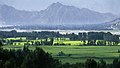 Lower reaches of the Swat River valley
 -
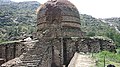 The Amluk-Dara stupa, one of many ancient Buddhist sites scattered throughout the river's valley


See also
- Rigvedic rivers
- Swat, Pakistan
- Barikot
References
- Book: Hidden Treasures of Swat, ISBN 978-969-23042-0-7
- ISBN 978-0-520-95766-4.
- ^ ISBN 978-0-19-547113-7.
- ^ Edward Herbert Bunbury (1879). A history of ancient geography among the Greeks and Romans. J. Murray.
- ISBN 978-0-19-958724-7.
- ISBN 978-81-7081-333-0.
- ISBN 978-1-78969-187-0.
- ^ "Feasibility study on the development of Munda Dam multipurpose project in Islamic Republic of Pakist an : final report ; Vol. 3. -Supporting report" (PDF). Japan International Cooperation Agency : Nippon Koei Co., Ltd. : Nippon Giken Inc. Archived (PDF) from the original on 7 October 2022.
- ^ "History". www.wapda.gov.pk. Retrieved 22 April 2021.
- ^ Report, Bureau (28 August 2010). "Munda Headworks restored in record time". DAWN.COM. Retrieved 22 April 2021.
- ^ [1][dead link]
- ^ "Korean companies asked to undertake $1.6bn of hydroelectric schemes in Pakistan". Global Construction Review. 8 January 2021. Retrieved 7 October 2021.
- ^ "Pre-qualification bids sought for E&M supply for Gabral Kalam, Pakistan … | Hydropower & Dams International". www.hydropower-dams.com. Retrieved 7 October 2021.
- ^ Poindexter, Gregory (5 December 2016). "Pakistan begins construction of the 84-MW Matiltan hydropower project". Hydro Review. Retrieved 7 October 2021.
External links
34°07′N 71°43′E / 34.117°N 71.717°E
| International | |
|---|---|
| National | |