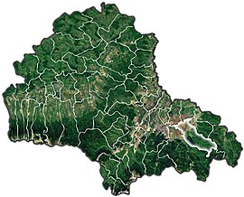
Tărlungeni
Tărlungeni
Tatrang | |
|---|---|
 View of Purcăreni | |
 Location within the county | |
| Coordinates: 45°38′N 25°45′E / 45.633°N 25.750°E | |
| Country | Romania |
| County | Brașov |
| Government | |
| • Mayor (2020–2024) | Severius-Florin Beșchea (PNL) |
| Area | 135.66 km2 (52.38 sq mi) |
| Elevation | 600 m (2,000 ft) |
| Population (2021-12-01)[1] | 12,067 |
| • Density | 89/km2 (230/sq mi) |
| Time zone | EET/EEST (UTC+2/+3) |
| Postal code | 507220 |
| Vehicle reg. | BV |
| Website | comunatarlungeni |
Tărlungeni (German: Tatrangen; Hungarian: Tatrang) is a commune in Brașov County, Transylvania, Romania. It is composed of four villages: Cărpiniș (Kerpenest), Purcăreni (Pürkerec), Tărlungeni and Zizin (Zajzon).
The commune is located in the southeastern part of the county, just east of the county seat, Brașov, and belongs to the Brașov metropolitan area. Tărlungeni lies on the banks of the river Tărlung and its affluent, the Zizin.
The first attestation of the locality dates back to November 4, 1484, when the voivode of Transylvania, Stephen V Báthory, came to Brașov to mediate a dispute between the villages of Prejmer and Tărlungeni over the usage of the waters of the river Tărlung.[2]
At the
Zizin is known for its mineral water springs, originating from the phreatic zone of the Ciucaș Mountains; the first official description of the springs dates from 1773.[4]
From 1983 to 2016 the Liga II football club CS Unirea Tărlungeni was based in the commune.
Natives
- György Barkó (born 1931), Romanian and Hungarian actor
- Ștefan Foriș (1892–1946), Romanian communist activist
See also
- Toma Roman Jr (October 21, 2012). "Cum l-a învins capitalismul pe Ceaușescu. Magazinul mixt din hogeacul cârmaciului". Jurnalul Național (in Romanian). Retrieved September 27, 2021.
References
- ^ "Populaţia rezidentă după grupa de vârstă, pe județe și municipii, orașe, comune, la 1 decembrie 2021" (XLS). National Institute of Statistics.
- ^ "Despre Tărlungeni". comunatarlungeni.ro (in Romanian). Tărlungeni townhall. Retrieved September 27, 2021.
- ^ "Populația rezidentă după grupa de vârstă, pe județe și municipii, orașe, comune, la 1 decembrie 2021" (in Romanian). INSSE. 31 May 2023.
- ^ "Apa minerală naturală Zizin". zizin.ro (in Romanian). Retrieved October 19, 2021.


