
Tanada Peak
| Tanada Peak | |
|---|---|
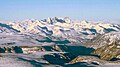
.jpg) North aspect | |
| Highest point | |
| Elevation | 9,358 ft (2,852 m)[1][2] |
| Prominence | 3,408 ft (1,039 m)[3] |
| Isolation | 13.6 mi (21.9 km)[3] |
| Coordinates | 62°18′06″N 143°30′20″W / 62.3018007°N 143.5055639°W[4] |
| Naming | |
| Etymology | Tanada Lake |
| Geography | |
 Tanada Peak Location in Alaska | |
| Country | United States |
| State | Alaska |
| Census Area | Copper River |
| Protected area | Wrangell–St. Elias National Park and Preserve |
| Parent range | Wrangell Mountains[2] |
| Topo map | USGS Nabesna B-6 |
| Geology | |
| Age of rock | Pleistocene |
| Mountain type | Eroded shield volcano[5] |
| Type of rock | Andesite, Dacite[5] |
| Volcanic arc/belt | Wrangell Volcanic Field |
| Last eruption | 970,000 years ago |
Tanada Peak is a 9,358-foot (2,852 m) mountain summit in the US state of Alaska.
Description
Tanada Peak is located in the
Geology
Tanada Peak is the erosional remnant of Tanada Volcano which was an andesitic shield volcano which probably began forming 1.5 million years ago, with the last eruption occurring 970,000 years ago.[1] Prior to one million years ago, the shield collapsed, forming a caldera. The peak is now the high point within a caldera measuring four miles (6.4 km) by six miles (9.7 km). An unnamed glacier in the caldera on the peak's southwest slope is a small remnant of the much larger glaciers that once covered the volcano and carved away much of the 400 km2 (154 square miles) shield.[1]
Climate
Based on the Köppen climate classification, Tanada Peak is located in a tundra climate zone, with long, cold, snowy winters, and cool summers.[9] Weather systems coming off the Gulf of Alaska are forced upwards by the Wrangell Mountains (orographic lift), causing heavy precipitation in the form of rainfall and snowfall. Winter temperatures can drop below -10 °F with wind chill factors below −20 °F. This climate supports an unnamed glacier and permanent ice surrounding the peak.
See also
Gallery
-
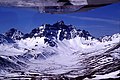
 Southeast aspect of Tanada Peak centered on skyline
 -
-
 Tanada Peak centered on skyline
.jpg)

.jpg)
References
- ^ a b c d Donald H. Richter, Guide to the Volcanoes of the Western Wrangell Mountains, Alaska: Wrangell-St. Elias National Park and Preserve, U.S. Government Printing Office, 1995, p. 20–21.
- ^ a b "Tanada Peak, Alaska". Peakbagger.com. Retrieved 2024-02-25.
- ^ a b "Tanada Peak - 9,358' AK". listsofjohn.com. Retrieved 2024-02-25.
- ^ a b c "Tanada Peak". Geographic Names Information System. United States Geological Survey, United States Department of the Interior. Retrieved 2024-02-25.
- ^ a b Charles A. Wood, Volcanoes of North America: United States and Canada, Cambridge University Press, 1992, p. 90.
- ^ "Tanada Peak, Peakvisor.com". Retrieved 2024-02-25.
- ^ Donald J. Orth, Dictionary of Alaska Place Names, U.S. Government Printing Office, 1967, page 946.
- ISBN 9780806135984, p. 478.
- ISSN 1027-5606.
External links
- Tanada Peak: weather forecast
Places adjacent to Tanada Peak | ||||||||||||||||
|---|---|---|---|---|---|---|---|---|---|---|---|---|---|---|---|---|
| ||||||||||||||||