
Tann, Hesse
Tann (Rhön) | |
|---|---|
 Landscape of Tann (View from northeast) | |
.png) Coat of arms | |
Location of Tann (Rhön) within Fulda district 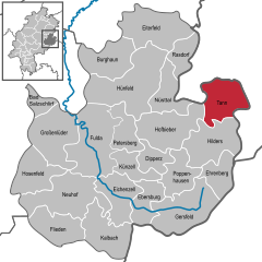 | |
 Tann (Rhön)  Tann (Rhön) | |
| Coordinates: 50°39′N 10°01′E / 50.650°N 10.017°E | |
| Country | Germany |
| State | Hesse |
| Admin. region | Kassel |
| District | Fulda |
| Subdivisions | 10 districts |
| Government | |
| • Mayor (2019–25) | Mario Dänner[1] (Ind.) |
| Area | |
| • Total | 60.45 km2 (23.34 sq mi) |
| Elevation | 400 m (1,300 ft) |
| Population (2022-12-31)[2] | |
| • Total | 4,565 |
| • Density | 76/km2 (200/sq mi) |
| Time zone | UTC+01:00 (CET) |
| • Summer (DST) | UTC+02:00 (CEST) |
| Postal codes | 36142 |
| Dialling codes | 06682 |
| Vehicle registration | FD |
| Website | www.tann-rhoen.de |
Tann is a town in the
Ulster River
.
Mayors
- Karl Hilgen (SPD) till 1983
- Wolfgang Schwake (CDU) till 1989
- Dieter Herchenhan] (SPD) till 2001
- Markus Meysner (CDU) till 2013
- Mario Dänner (independent) since 2013[3]
Buildings
-
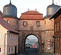 City gate of Tann (built 1557–1563)
 -
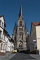 Protestant church
 -
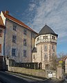
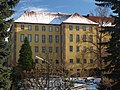 Tann yellow castle
 -
 Tann blue castle

,_Ev._Stadtpfarrkirche-20160505-001.jpg)


Sons and daughters of the town
- Johann Ludwig Klüber (1762-1837), state lawyer and writer
Personalities who have worked on the spot
- Johann Michael Bach (musician at Wuppertal) (1745-1820), a member of the musical Bach family. Worked in Tann as a church musician (1786 to ca. 1795)
- Sebastian Kehl (born 1980, Fulda), grew up in the district Lahrbach, professional football player (Borussia Dortmund
References
- Hessisches Statistisches Landesamt. 5 September 2022.
- Hessisches Statistisches Landesamt. June 2023.
- ^ Endgültiges Wahlergebnis der Bürgermeisterwahl von 2013
Towns and municipalities in Fulda district | ||
|---|---|---|
 | ||
| International | |
|---|---|
| National | |
| Geographic | |
This Hesse location article is a stub. You can help Wikipedia by expanding it. |