
Taunton Stop Line

The Taunton Stop Line was a World War II defensive line in southwest England. It was designed "to stop an enemy's advance from the west and in particular a rapid advance supported by armoured fighting vehicles (up to the size of a German medium tank) which may have broken through the forward defences."[1]
History
The Taunton Stop Line was one of more than fifty similar defensive lines that were constructed around England in WWII, all designed to compartmentalise the country to contain any breakthrough until reinforcements could arrive. Stop Lines used a combination of geography and construction to make continuous defences. The innermost and longest was the
The Taunton Stop Line ran north–south for nearly 50 miles (80 km) through
Aside from the obstacles created by canals, rivers and railway embankments, by early 1942 the line was defended by 309
To reinforce the line and deny access to the major east–west routes that passed through the line, in 1941 twelve "Defensive Islands" were added to the line under a plan devised by
Two
Many pillboxes can still be seen along the length of the line.
Gallery
-
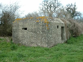 Pillbox on Taunton Stop Line.
 -
 Vickers medium machine gun emplacement with large, stepped embrasure. Along the Taunton Stop Line these are typically found in pairs.
 -
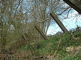 Anti-tank posts each about 8 inches (20 cm) square and projecting about 6 feet (1.8 m), made from reinforced concrete, at the top of the eastern side of a steep railway cutting. They were intended to stop enemy tanks climbing the steep side of the cutting.
 -
 One of a pair of blocks that allowed the railway line to be blocked quickly by inserting a barrier such as a section of rail. The rail block was intended to stop enemy tracked vehicles from travelling along the railway route. The mass of concrete stands on a foundation and is about 5 feet (1.5 m) high.


See also
- British anti-invasion preparations of World War II
- British hardened field defences of World War II
- GHQ Line
- Coquet Stop Line
- Outer London Defence Ring
- Bridgwater and Taunton Canal
- Ringwood West Line
References
- ^ "History". Axminster. Retrieved 4 October 2016.
- ^ "Somerset Pillboxes". Somerset Pillboxes. Retrieved 19 January 2013.
- ^ "Second World War stop line (General Headquarters Line)". Somerset Historic Environment Record. Somerset County Council. Retrieved 19 January 2013.
- ^ "Second World War stop line, The Taunton Stop Line". Somerset Historic Environment Record. Somerset County Council. Retrieved 19 January 2013.
External links
- UK Invasion Defence Remains
- "The Stop Line Way Multi-user Path Seaton to Colyford and Cloakham Lawn to Weycroft East Devon" – An Archaeological Desk-based Assessment (part 1) and (part 2)
- "Land off Morton Way, Axminster, Devon – A Limited Archaeological Excavation and Recording Programme" (pdf). Archaeology Data Service. Context One Archaeological Services 2010. 2010. Retrieved 14 May 2011.