Terre-et-Marais
Terre-et-Marais | |
|---|---|
 The church in Sainteny | |
| Coordinates: 49°14′20″N 1°18′50″W / 49.239°N 1.314°W | |
| Country | France |
| Region | Normandy |
| Department | Manche |
| Arrondissement | Saint-Lô |
| Canton | Carentan-les-Marais |
| Intercommunality | Baie du Cotentin |
| Government | |
| • Mayor (2020–2026) | Jean-Pierre Jacquet[1] |
| Area 1 | 35.59 km2 (13.74 sq mi) |
| Population (2021)[2] | 1,304 |
| • Density | 37/km2 (95/sq mi) |
| Time zone | UTC+01:00 (CET) |
| • Summer (DST) | UTC+02:00 (CEST) |
| INSEE/Postal code | 50564 /50500 |
| 1 French Land Register data, which excludes lakes, ponds, glaciers > 1 km2 (0.386 sq mi or 247 acres) and river estuaries. | |
Terre-et-Marais (French pronunciation: [tɛʁ e maʁɛ], literally Land and Marsh) is a commune in the department of Manche, northwestern France.
Toponymy
The name of the commune refers to the marshes of Carentan.
History

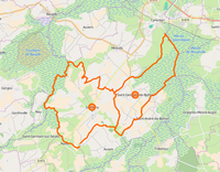
The municipality was established on 1 January 2016 by merger of the former communes of Sainteny (the seat) and Saint-Georges-de-Bohon.[3] The communes of Saint-Georges-de-Bohon and Sainteny become delegated communes.
Education
This section is empty. You can help by adding to it. (January 2020) |
Sport
This section is empty. You can help by adding to it. (January 2020) |
Administration
| Election | Mayor | Party | Occupation | |
|---|---|---|---|---|
| 2016 | Alain Langlois | SE | Chief of construction, Delegate mayor of Saint-Georges-de-Bohon | |
See also
References
Wikimedia Commons has media related to Terre-et-Marais.
- ^ "Répertoire national des élus: les maires" (in French). data.gouv.fr, Plateforme ouverte des données publiques françaises. 13 September 2022.
- ^ "Populations légales 2021". The National Institute of Statistics and Economic Studies. 28 December 2023.
- ^ Arrêté préfectoral 16 December 2015 (in French)
External links
Wikimedia Commons has media related to Terre-et-Marais.
- Terre-et-Marais official website (in French)


