
The Sundial (Zion National Park)
| The Sundial | |
|---|---|
 The Sundial, east aspect at dawn (The Witch Head to right) | |
| Highest point | |
| Elevation | 7,590 ft (2,310 m)[1] |
| Prominence | 530 ft (160 m)[1] |
| Parent peak | The West Temple (7,810 ft)[1] |
| Isolation | 0.38 mi (0.61 km)[1] |
| Coordinates | 37°12′56″N 113°01′27″W / 37.2155109°N 113.0242192°W[2] |
| Geography | |
 The Sundial Location in Utah  The Sundial The Sundial (the United States) | |
| Country | United States |
| State | |
The Sundial is a 7,590-foot (2,310-meter) elevation white Navajo Sandstone summit located in Zion National Park, in Washington County of southwest Utah, United States.[2]
Description
The Sundial is situated in the "Towers of the Virgin", 2.5 mi (4.0 km) west of Zion's park headquarters, towering 3,600 feet (1,100 meters) above the floor of
U.S. Board on Geographic Names.[2]
Climate
Spring and fall are the most favorable seasons to visit The Sundial. According to the
Cold semi-arid climate zone, which is defined by the coldest month having an average mean temperature below 32 °F (0 °C), and at least 50% of the total annual precipitation being received during the spring and summer. This desert climate receives less than 10 inches (250 millimeters) of annual rainfall, and snowfall is generally light during the winter.[3]
Gallery
-
 West aspect of Sundial. West Temple to right
 -
 The Sundial centered, from the southwest
 -
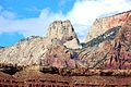
 The West Temple (left), The Sundial, The Witch Head, Altar of Sacrifice (right)
 -
 The West Temple (left), The Sundial, The Witch Head, Altar of Sacrifice (right)
 -
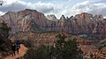
 Towers of the Virgin. Left to right:The Sundial, The Witch Head, Broken Tooth, Rotten Tooth, Altar of Sacrifice (upper right).
 -
 The Sundial (left) and The Witch Head (right)
 -
 The West Temple (left), The Sundial (right)
 -
 Mt. Kinesava (centered), The Sundial to left, seen from Grafton cemetery
 -
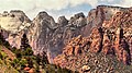
 The Sundial (left), The Witch Head, Broken Tooth, Rotten Tooth, Altar of Sacrifice.
 -
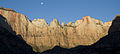 Moon over The Sundial
 -
 The Sundial from Chinle Trail


.jpg)
_with_the_Towers_of_the_Virgin.jpg)


.jpg)

.jpg)

See also
References
- ^ a b c d e "Sundial, The - 7,590' UT". listsofjohn.com. Retrieved 2020-09-10.
- ^ a b c U.S. Geological Survey Geographic Names Information System: The Sundial
- ^ "Zion National Park, Utah, USA - Monthly weather forecast and Climate data". Weather Atlas. Archived from the original on January 27, 2019. Retrieved 31 August 2020.
External links
Wikimedia Commons has media related to The Sundial (Zion National Park).
- Zion National Park National Park Service
- Weather forecast
- Web cam