Thermal low

Thermal lows, or heat lows, are non-
On land, intense, rapid solar heating of the earth's surface causes the heating of the lowest layers of the atmosphere, via re-radiated energy in the infrared spectrum. The hotter air is less dense than surrounding cooler air and rises, leading to the formation of a low pressure area. Elevated areas can enhance the strength of the thermal low because they warm more quickly than the atmosphere which surrounds them at the same altitude. Over water, instability lows form during the winter when the air overlying the land is colder than the warmer water body.
Thermal lows can extend to 3,100 metres (10,200 ft) in height and tend to have weak circulations. Thermal lows over the western and southern portions of North America, northern Africa, and Southeast Asia are strong enough to lead to summer monsoon conditions. Thermal lows inland of the coastline lead to the development of sea breezes which, combined with rugged topography near the coast, can lead to poor air quality. Owing to the very high temperatures in the centre of heat lows, there are relatively few direct observations of thermal lows.
Formation

In deserts, the lack of ground and plant moisture, that would normally provide
Role in the monsoon regime

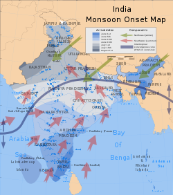
Monsoons are caused by the larger amplitude of the seasonal cycle of land temperature compared to that of nearby oceans. That differential warming happens because heat in the ocean is mixed vertically through a "mixed layer" that may be fifty meters deep, due to the action of wind and buoyancy-generated
In winter, the land cools off quickly, but the ocean retains its heat longer due to its higher specific heat. The hot air over the ocean rises, creating a low pressure area and a breeze from land to ocean while a large area of drying high pressure is formed over the land, increased by wintertime cooling.
Role in sea breeze formation

The
Along the California coast, the cooler water creates a surface marine layer that is much cooler than inland areas during the summer. At the same time, the intense heating inland generates a pronounced thermal trough aligned with the Central Valley, and typically linked to the broader thermal low across the North American deserts. As a consequence, a strong pressure gradient is created which draws cool marine air landward. As temperatures plummet, fog and stratus stream in and through the gaps of the Coast Ranges, and especially through the
Role in air pollution
In hilly or mountainous areas near the coastline, thermally-forced sea breezes, combined with wind circulations up the sides of the mountains, can encourage the production of chemicals which can lead to the development of smog. Pollution has been tracked into the mid-levels of the troposphere in the form of ozone, which is concentrated over the circulation of the thermal low as well as adjacent oceanic areas.[23]
References
- ^ a b Glossary of Meteorology (2009). Thermal Low. Archived 2008-05-22 at the Wayback Machine American Meteorological Society. Retrieved on 2009-03-02.
- ^ National Weather Service Office in Tucson, Arizona (2008). What is a monsoon? National Weather Service Western Region Headquarters. Retrieved on 2009-03-08.
- ^ Douglas G. Hahn and Syukuro Manabe (1975). The Role of Mountains in the South Asian Monsoon Circulation. Journal of the Atmospheric Sciences, vol. 32, Issue 8, pp. 1515-1541. Retrieved on 2009-03-08.
- ^ Nathaniel S. Winstead and Pierre D. Mourad (2000). Shallow Great Lake–Scale Atmospheric Thermal Circulation Imaged by Synthetic Aperture Radar. Monthly Weather Review: pp. 3654–3663. Retrieved on 2009-03-09.
- ^ David R. Rowson and Stephen J. Colucci (1992). Synoptic climatology of thermal low-pressure systems over south-western north America. International Journal of Climatology, Vol. 12 Issue 6, pp. 529-545. Retrieved on 2009-03-08.
- ^ United States Navy (2008). Forecasters Handbook for the Arctic Appendix B: Mean Monthly Sea Level Pressure, Air Temperature, and 700-mb Height. Archived 2016-12-26 at the Wayback Machine Retrieved on 2009-03-08.
- ^ National Weather Service Forecast Office Columbia, South Carolina (2009). Weather Terms. National Weather Service Eastern Region Headquarters. Retrieved on 2009-03-08.
- ^ Glossary of Meteorology (2009). Warm Low. Archived 2007-08-17 at the Wayback Machine American Meteorological Society. Retrieved on 2009-04-04.
- ^ Gongyuh Lin (2008). Synoptic Weather Systems. California State University, Northridge. Retrieved on 2009-04-04.
- ^ Donna F. Tucker (1998). The Summer Plateau Low Pressure System of Mexico. Journal of Climate: pp. 1002–1015. Retrieved on 2009-03-09.
- ^ Marcelo E. Seluchi, A. Celeste Saulo, Matilde Nicolini, and Prakki Satyamurty (2003). The Northwestern Argentinean Low: A Study of Two Typical Events. Monthly Weather Review: pp. 2361–2378. Retrieved on 2009-03-09.
- ISBN 978-0-415-27171-4. Retrieved on 2009-03-08.
- ^ Bureau of Meteorology. "Climate of Giles". Archived from the original on 2008-08-11. Retrieved 2008-05-03.
- ^ B. Pu and K. H. Cook (2008). Dynamics of the Low-Level Westerly Jet Over West Africa. American Geophysical Union, Fall Meeting 2008, abstract #A13A-0229. Retrieved on 2009-03-08.
- ^ a b Dr. Louisa Watts (2009). What causes the west African monsoon? National Centre for Environmental Science. Retrieved on 2009-04-04.
- ^ Dr. Michael Pidwirny (2008). CHAPTER 8: Introduction to the Hydrosphere (e). Cloud Formation Processes. Physical Geography. Retrieved on 2009-01-01.
- ^ Bart van den Hurk and Eleanor Blyth (2008). Global maps of Local Land-Atmosphere coupling. Archived 2009-02-25 at the Wayback Machine KNMI. Retrieved on 2009-01-02.
- ISBN 978-0-12-548035-2. Retrieved on 2009-01-02.
- ^ Glossary of Meteorology. Gust Front. Archived 2011-05-05 at the Wayback Machine Retrieved on 2008-07-09.
- ^ BBC Weather. The Asian Monsoon. Retrieved on 2008-05-22.
- University of Wisconsin. Retrieved on 2006-10-24.
- ^ JetStream: An Online School For Weather (2008). The Sea Breeze. Archived 2006-09-23 at the Wayback Machine National Weather Service Southern Region. Retrieved on 2006-10-24.
- ^ A.C. Carvalho, A. Carvalho, I. Gelpi, M. Barreiro, C. Borrego, A.I. Miranda, V. Perez-Munuzuri (2006). Influence of topography and land use on pollutants dispersion in the Atlantic coast of Iberian Peninsula.[permanent dead link] Atmospheric Environment 40 (2006) 3969–3982. Retrieved on 2009-03-09.
