
Timóteo (municipality)
Timóteo | |
|---|---|
Municipality | |
| Municipality of Timóteo | |
 Partial view of Timóteo seen from the Primavera neighborhood | |
|
UTC−3 (BRT) | |
| HDI (2010) | 0,770 – high |
| Website | http://www.timoteo.mg.gov.br/ |
Timóteo is a Brazilian
Vale do Aço). It is the hometown of Aperam South America (old Acesita), a steel factory specialized in the production of stainless steel, now named Aperam
.
The municipality contains part of the 35,970 hectares (88,900 acres) Rio Doce State Park, created in 1944, the first state-level conservation unit in Minas Gerais.[2]
-
 Aperam South America's central headquarter
 -
 Sinergia Monument
 -
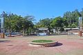 1º de Maio (1 May) Square, in the Centro-Norte (North-Central).
 -
 Saint Joseph the Worker church (North-Central)
 -
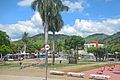 29 de Abril (29 Abril) Square, in the Centro-Sul (South-Central).
 -
 Saint Sebastian Mother Church (South-Central)


External links
References
- ^ IBGE 2020
- ^ Parque Estadual do Rio Doce (in Portuguese), IEF: Instituto Estadual de Florestas MG, retrieved 2017-02-06
19°34′58″S 42°38′38″W / 19.58278°S 42.64389°W

This geographical article relating to Minas Gerais is a stub. You can help Wikipedia by expanding it. |