
Trappers Peak
| Trappers Peak | |
|---|---|
 Trappers Peak, southwest aspect | |
| Highest point | |
| Elevation | 5,966 ft (1,818 m)[1] |
| Prominence | 566 ft (173 m)[1] |
| Parent peak | X Mountain (5,980 ft)[2] |
| Isolation | 0.48 mi (0.77 km)[2] |
| Coordinates | 48°41′18″N 121°19′21″W / 48.6883391°N 121.3224443°W[3] |
| Geography | |
 Trappers Peak Location in Washington  Trappers Peak Trappers Peak (the United States) | |
| Country | United States |
| State | Washington |
| County | Whatcom |
| Protected area | North Cascades National Park Stephen Mather Wilderness |
| Parent range | North Cascades |
| Topo map | USGS Mount Triumph |
| Climbing | |
| Easiest route | scrambling |
Trappers Peak is a 5,966-foot (1,818 m) elevation mountain summit located in the
North Cascades Highway in approximately two miles. The nearest higher neighbor is Thornton Peak, 1.5 miles (2.4 km) to the northwest, Mount Triumph is two miles to the northwest, and Newhalem is three miles to the east-southeast.[1] Precipitation runoff from the mountain drains into tributaries of the Skagit River. The summit of Trappers Peak is known for its grand view of the jagged peaks of the Picket Range
.
Climate
Trappers Peak is located in the
Cascade Mountains. As fronts approach the North Cascades, they are forced upward by the peaks of the Cascade Range (orographic lift), causing them to drop their moisture in the form of rain or snowfall onto the Cascades. As a result, the west side of the North Cascades experiences high precipitation, especially during the winter months in the form of snowfall.[5] Because of maritime influence, snow tends to be wet and heavy, resulting in avalanche danger.[5] During winter months, weather is usually cloudy, but due to high pressure systems over the Pacific Ocean that intensify during summer months, there is often little or no cloud cover during the summer.[5]
Geology
The North Cascades features some of the most rugged topography in the
glacial valleys. Geological events occurring many years ago created the diverse topography and drastic elevation changes over the Cascade Range leading to the various climate differences. These climate differences lead to vegetation variety defining the ecoregions
in this area.
The history of the formation of the Cascade Mountains dates back millions of years ago to the late
During the Pleistocene period dating back over two million years ago, glaciation advancing and retreating repeatedly scoured the landscape leaving deposits of rock debris.[6] The U-shaped cross section of the river valleys is a result of recent glaciation. Uplift and faulting in combination with glaciation have been the dominant processes which have created the tall peaks and deep valleys of the North Cascades area.
Gallery
-
 Trappers Peak and lower Thornton Lake from northwest
 -
 Looking south at Trappers Peak (centered), Mt. Triumph in upper right corner.
 -
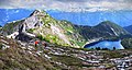
 Picket Range from Trappers Peak
 -
 Picket Range from Trappers Peak
 -
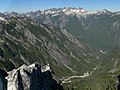
 Mts. Triumph, Despair, and the Pickets from Trappers Peak
 -
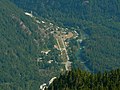 Newhalem, Washington seen from Trappers Peak


See also
Geography of the North Cascades
References
- ^ a b c "Trappers Peak, Washington". Peakbagger.com.
- ^ a b "Trappers Peak - 5,966' WA". listsofjohn.com. Retrieved 2021-06-24.
- ^ "Trappers Peak". Geographic Names Information System. United States Geological Survey, United States Department of the Interior. Retrieved 2021-06-24.
- ISBN 9780898864236., page 92.
- ^ ISBN 978-0-89886-838-8.
- ^ a b c d Kruckeberg, Arthur (1991). The Natural History of Puget Sound Country. University of Washington Press.
External links
- North Cascades National Park National Park Service
- Hiking Trappers Peak: Hikingproject.com
- Trappers Peak: Mountain-forecast.com
- Trappers Peak: Flickr photo
Places adjacent to Trappers Peak | |
|---|---|