
Tronchetto
 Landing place of ferry from Tronchetto to Lido di Venezia | |
 | |
| Geography | |
|---|---|
| Coordinates | 45°26′26″N 12°18′18″E / 45.440556°N 12.305°E |
| Adjacent to | Venetian Lagoon |
| Administration | |
| Region | Veneto |
| Province | Province of Venice |
Tronchetto (also known as Isola nuova, meaning "New island") is an artificial island in the Venetian Lagoon, northern Italy, located at the westernmost tip of the main Venice island.
The island was created in the 1960s, and now is used as a
Venice People Mover connects Tronchetto with Piazzale Roma
, the main Venice bus station, which lies at the edge of the city center.
Gallery
-
 Ferry from Tronchetto toLido di Venezia
 -
 Construction of structures for the people mover in 2009
 -
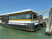 Tronchetto Market Vaporetto stop
.jpg)


References
Wikimedia Commons has media related to Tronchetto.
- ^ "Tronchetto Parking Garage". Europe for Visitors. Retrieved August 26, 2011.
This article on a location in Veneto is a stub. You can help Wikipedia by expanding it. |