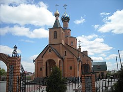
Tsyrkuny
Tsyrkuny
Циркуни | |
|---|---|
 | |
|
UTC+3 (EEST) | |
| Postal code | 62441 |
| Area code | +380 57 |
 | |
Tsyrkuny (Ukrainian: Циркуни) is a village in Kharkiv Raion (district) in Kharkiv Oblast of eastern Ukraine, at about 16 kilometres (9.9 mi) north-east from the centre of Kharkiv city. It hosts the administration of Tsyrkuny rural hromada, one of the hromadas of Ukraine.[1]
The settlement came under
Demographics
The settlement had 6310 inhabitants in 2001, native language distribution as of the
Ukrainian Census of 2001:[4]
- Ukrainian: 75.88%
- Russian: 23.20%
- Belarusian: 0.25%
- Moldovan (Romanian): 0.22%
- Armenian: 0.17%
- other languages: 0.56%

References
- ^ "Циркуновская громада" (in Russian). Портал об'єднаних громад України.
- ^ "Russian Offensive Campaign Assessment, May 20". understandingwar.org. ISW. 20 May 2022. Retrieved 15 June 2022.
Russian forces are reportedly fighting in Vesele, Tsyrkuny, Zolochiv, and Ternova and may have recaptured Ternova and Rubizhne, although ISW cannot independently confirm these claims at this time.
- ^ "Operational information on 11.06.2022". odessa-journal.com. 11 June 2022. Retrieved 15 June 2022.
In addition, the enemy fired on civilian infrastructure in the areas of the settlements of Uda, Prudyanka, Tsyrkuny and Verkhniy Saltiv. It struck air strikes in the Ternova and Rubizhne districts.
- ^ "Офіційна сторінка Всеукраїнського перепису населення | Банк даних" [All-Ukrainian population census | Database]. ukrcensus.gov.ua (in Ukrainian). Retrieved 25 April 2023.
