
United Nations station (LRT)
United Nations | |||||||||||
|---|---|---|---|---|---|---|---|---|---|---|---|
 | |||||||||||
| General information | |||||||||||
| Other names | U.N. Avenue | ||||||||||
| Location | Taft Avenue, Ermita Manila, Metro Manila, Philippines | ||||||||||
| Owned by | Department of Transportation Light Rail Manila Corporation | ||||||||||
| Line(s) | Line 1 | ||||||||||
| Platforms | 2 (2 side) | ||||||||||
| Tracks | 2 | ||||||||||
| Construction | |||||||||||
| Structure type | Elevated | ||||||||||
| Parking | Yes (Times Plaza & The Pearl Manila) | ||||||||||
| Other information | |||||||||||
| Station code | UN | ||||||||||
| History | |||||||||||
| Opened | December 1, 1984 | ||||||||||
| Services | |||||||||||
| |||||||||||
| Location | |||||||||||
 United Nations Location within Metro Manila | |||||||||||
United Nations station is an elevated
Ermita, Manila. It is situated above the intersection of Taft and United Nations Avenues. The station is named after United Nations Avenue, which in turn is named after the United Nations
organization.
United Nations station is also near educational institutions such as the
Plaza Salamanca and Plaza Rueda, as well as Paco Park. The station was also adjacent to the now-defunct Philam Life Building
.
United Nations station is the seventh stop from Baclaran and the twelfth from Fernando Poe Jr.
Transportation links
United Nations station is served by buses, jeepneys, and UV Express along Taft Avenue and other nearby routes. Regular taxis and cycle rickshaws also stop at and near the station.
Gallery
-
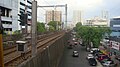 Overview of United Nations, Manila, from United Nations LRT station
 -
 The rails
 -
 Platform area, panoramic view


See also
- List of rail transit stations in Metro Manila
- Manila Light Rail Transit System