
Upper Sheringham
| Upper Sheringham | ||
|---|---|---|
Shire county | ||
| Region | ||
| Country | England | |
| Sovereign state | United Kingdom | |
| Post town | SHERINGHAM | |
| Postcode district | NR26 | |
| Dialling code | 01263 | |
| Police | Norfolk | |
| Fire | Norfolk | |
| Ambulance | East of England | |
| UK Parliament | ||
Upper Sheringham is a village and a civil parish in the English county of Norfolk.[1] The village is 26.8 miles (43.1 km) north-north-west of Norwich, 6 miles (9.7 km) west of Cromer and 132 miles (212 km) north-north-east of London. The village is 1.2 miles (1.9 km) from the town of Sheringham.
The nearest railway station is at
A148 King's Lynn]to Cromer road just to the south. The parish of Upper Sheringham at the 2001 census had a population of 214, reducing slightly to 209 at the 2011 census.[3] For the purposes of local government, the parish falls within the district of North Norfolk
.
Description
The name Sheringham is of
Viking warlord who was given the land as a reward for his performance in battle. The village is located a little south west below the town of Sheringham. The village is bound to the west by Sheringham Hall and its estate. To the south is the hill line known as the Cromer Ridge. The village is known locally as "Upper Town" as compared to the town of Sheringham
(town) itself.
All Saints' Church
The
rood loft described as "the best survival of its kind in all East Anglia's 1200-odd medieval churches."[5]
References
- ISBN 978-0-319-23815-8.
- ISBN 978-1-84348-614-5
- ^ "Parish population 2011". Retrieved 25 August 2015.
- ISBN 0-9524810-5-7
- ^ "Norfolk Churches".
Wikimedia Commons has media related to Upper Sheringham.
Gallery
-
 The village
 -
 Row of cottages
 -
 The war memorial located at the church of All Saints
 -
 The reservoir. All Saints church is in the background.
 -
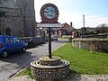 The village sign depicts a lifeboat
 -
 All Saints church


