
Utah State Route 99
Route map:
State Route 99 | ||||
|---|---|---|---|---|
| I-15 Business Loop, Fillmore | ||||
 SR-99 highlighted in red | ||||
| Route information | ||||
| Maintained by UDOT | ||||
| Length | 4.193 mi[1] (6.748 km) | |||
| Existed | 1969–present | |||
| Major junctions | ||||
| South end | ||||
| North end | ||||
| Location | ||||
| Country | United States | |||
| State | Utah | |||
| Highway system | ||||
| ||||
| ||||


State Route 99 (SR-99) is a
US-91
.
Route description
The highway begins at a
SR-100, the road loses two lanes at 300 North. The highway passes Paradise Resort Golf Course before turning northwest and terminating at another diamond interchange at I-15, exit 167.[2]
Photo Gallery
-
 First northbound trailblazer on SR-99 at the south end of Fillmore (May 2020)
 -
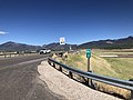 The southern end of SR-99 at I-15 exit 163 (May 2020)
 -
 One of Utah's intersections of consecutively-numbered routes (May 2020)
 -
 The north end of Route 99 (May 2020)


History
State Route 99 was established in 1969 coinciding with the construction of
US-91 was routed along this road but as I-15 was replacing US-91, the state assumed maintenance of the road. Previously, State Route 99 was assigned to a road also in Millard County that linked the Topaz War Relocation Center used in World War II.[citation needed
]
Major intersections
The entire route is in Fillmore, Millard County.
| mi[1] | km | Destinations | Notes | ||
|---|---|---|---|---|---|
| 0.000– 0.193 | 0.000– 0.311 | Southern terminus, also Exit 163 on I-15 | |||
| 3.094 | 4.979 | This is one of about a dozen places in Utah where two consecutively numbered routes meet. | |||
| 3.979– 4.193 | 6.404– 6.748 | Salt Lake City | Northern terminus, also Exit 167 on I-15 | ||
| 1.000 mi = 1.609 km; 1.000 km = 0.621 mi | |||||
References
KML is from Wikidata
- ^ a b "State Route 99 Highway reference". Utah Department of Transportation.
- ^ Google (June 8, 2009). "Utah State Route 99" (Map). Google Maps. Google. Retrieved June 8, 2009.