
Vadavalli
Vadavalli | |
|---|---|
Neighbourhood | |
UTC+5:30 (IST) | |
| PIN | 641041 |
| Telephone code | 0422 |
| Vehicle registration | TN-66; TN-38 |
Vadavalli is a neighborhood in
Geography
Vadavalli is about 9.1km from
Traditionally an agricultural community, Vadavalli is now a popular residential precinct. Also, it boasts of a large number of educational institutions in its surroundings, inclusive of both schools and colleges. For instance, the Anna University Regional Campus, Bharathiar University and the Government Law College are located 4 km from Vadavalli. Avila Convent and Kalveeram Palayam Government School are two of the premier schools which are located in and around Vadavalli.
Demographics
According to the 2001 India census,[1] Vadavalli has a population of 444,700. Males and females constitute equal parts of the population - both being 50%. Vadavalli has an average literacy rate of 78%, which is significantly higher than the national average of 59.5% - the male literacy is 83%, and the female literacy is 74%. 9% of the population is under 6 years of age.
In 2011, Vadavalli was recorded as having been incorporated into
Historical locations
A famous
-
 Vadavalli Bus Stand
 -
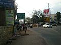 Thondamuthur - Marudamalai Road Junction


References
- ^ "Census of India 2001: Data from the 2001 Census, including cities, villages and towns (Provisional)". Census Commission of India. Archived from the original on 16 June 2004. Retrieved 1 November 2008.