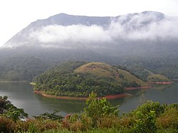
Siruvani River
| Siruvani River | |
|---|---|
 | |
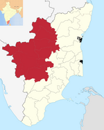
| Map |

The Siruvani River is a river near
tourist attractions in Southern India, namely, the Siruvani Dam and the Siruvani Waterfalls. The dam is also near The Banan Fort. Banan Fort and the Siruvani Dam, are 15 to 25 kilometres (9 to 16 mi) west of Coimbatore city. The river has a village named after it, or possibly vice versa.[citation needed
]
Dam
In 2012, the
Tirupur districts.[1][3] Tamil Nadu has threatened to take up the matter with the Supreme Court of India.[4][5] It receives the Siruvani River, a perennial stream of Palakkad District, and gets reinforced by the Kundah river before entering Erode District in Sathyamangalam Tamil Nadu.[citation needed
]
References
- ^ a b "Human chain formed against Kerala's plan to build dam on River Siruvani". NDTV. 26 June 2012. Retrieved 28 June 2012.
- ^ "Kerala plans dam across Siruvani". The Hindu. Thiruvananthapuram. 10 June 2012. Retrieved 28 June 2012.
- ^ "Human chain slams Kerala move for dam". The Hindu. 26 June 2012. Retrieved 28 June 2012.
- ^ "Tamil Nadu to take Kerala dam plan on Siruvani to Supreme Court: Minister". The Times of India. Coimbatore. 26 June 2012. Archived from the original on 6 January 2014. Retrieved 28 June 2012.
- ^ "Tamil Nadu will move SC if Kerala goes ahead with Siruvani dam plan". The Times of India. Coimbatore. 25 June 2012. Archived from the original on 6 January 2014. Retrieved 28 June 2012.
External links
Wikimedia Commons has media related to Siruvani River.

