
Vesterålen
 | |
 Vesterålen location in Norway  Vesterålen Vesterålen (Nordland) | |
| Geography | |
|---|---|
| Coordinates | 68°50′11″N 14°32′29″E / 68.8364°N 14.5414°E |
| Archipelago | Vesterålen archipelago |
| Major islands | Langøya, Hinnøya, Andøya, Hadseløya |
| Area | 2,511 km2 (970 sq mi) |
| Administration | |
Norway | |
| Demographics | |
| Population | 30,419 |
Vesterålen (/ˈvɛstərɔːlən/ VEST-ər-aw-lən,[1] Norwegian: [ˈvɛ̂stəroːɫn̩])[2] is a district and archipelago in Nordland county, Norway. It is located just north of Lofoten and west of Harstad. It is the northernmost part of Nordland county. Sortland is the largest town, situated near the center of the archipelago. Vesterålen includes the municipalities of Andøy, Bø, Hadsel, Sortland, and Øksnes.[3]
Name
The Old Norse forms of the name were Vestráll and Vestrálar (plural). The first element is vestr which means "west" and the last element is áll which means "(deep and narrow) sound" or "strait". The name describes the seaway west of the island of Hinnøya. The old name of the seaway east of Hinnøya (now called Tjeldsundet) might have been Austráll (meaning "the eastern sound/strait").
Geography
Vesterålen consists of the municipalities of
The landscape is mountainous, but the mountains have a more rounded shape compared to the mountains in Lofoten. The towns and villages are situated on the coastal brim (Strandflaten) between the mountains and the fjords. There are also several lakes, such as
Transportation
Vesterålen is connected to the mainland and
The coastal steamer
Economy
The population in Vesterålen as of 1 January 2004 was 30,648 according to
Fishing, in particular cod fisheries, has always been important in Vesterålen. There is also fish farming, and some agriculture in Vesterålen.
Media gallery
-
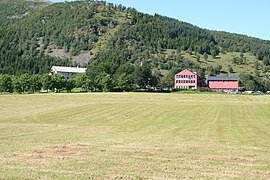 The high school for agriculture at Kleiva, Sortland municipality
 -
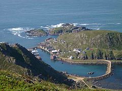 Nyksund (1 August 2004)
 -
 View towards Ræka, Sortland
 -
 TheAurora Borealisis visible in all of Vesterålen. Andøy, October 2007.
 -
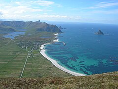 The village of Bleik in Andøy, with the long beach and a sea bird colony on the small island Bleiksøya. The deep ocean is very close to shore here, and sperm whales feed in this area.


References
- ISBN 9780191727665.
- ^ "Lofoten and Vesterålen". Collins English Dictionary. HarperCollins. Retrieved 20 July 2023.
- Store norske leksikon. "Vesterålen"(in Norwegian). Retrieved 2012-07-22.
External links
| International | |
|---|---|
| National | |