Vierlande
Appearance
| Location of the Vierlande
in Hamburg | |
|---|---|

| |
| Base data for Vierlande | |
| Country: | Germany |
Bundesland : |
Hamburg |
| Bezirk: | Bergedorf |
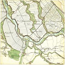
Vierlande is the name given to a roughly 77-square kilometre region in the Hamburg district of Bergedorf which has a population of 18,419 [1] and comprises four quarters of the city.
Its name goes back to the year 1556 and refers to the four
which are identical with their modern-day quarters.Geography
The Vierlande consists of former river islands in the Elbe.
History

The populace of the Vierlande were free farmers, but sovereignty over the whole region frequently changed hands. From the 12th century it belonged to the dukes of
District of Harburg until the enactment of the Greater Hamburg Act
in 1938.
Altengamme is first mentioned in the records in 1188; Neuengamme ("New Island") and Kirchwerder in 1212, and Curslack in 1217.

Dyke construction
The first dykes were constructed in the 12th century as part of land reclamation.
Museums


The
Fachhallenhaus and is an open-air museum in Curslack. It is part of the Bergedorf Museum Landscape (Bergedorfer Museumslandschaft), which also manages the regional museum, the Museum for Bergedorf and the Vierlande (Museum für Bergedorf und die Vierlande) in Bergedorf Castle
].
Literature
- Torkild Hinrichsen: Natur - Kultur. Ein Lehrstück aus den Vierlanden. In: Lichtwark-Heft No. 72, Verlag HB-Werbung, Hamburg-Bergedorf 2007, ISSN 1862-3549.
- Harald Richert: Hutständer - eine Besonderheit der Vierländer Kirchen. In: Lichtwark-Heft No. 69, Verlag HB-Werbung, Hamburg-Bergedorf 2004, ISSN 1862-3549.
- H. Schween: Zur Geschichte der Vierlande. In: Lichtwark Nr. 11., 1. Jahrg., Hrsg. Lichtwark-Ausschuß, Bergedorf 1949. Siehe jetzt: Verlag HB-Werbung, Hamburg-Bergedorf.
- Achim Sperber: Vier- und Marschlande, Land hinterm Deich. Hans Christians Verlag, Hamburg 1981, ISBN 3-7672-0734-6.
- Ludwig Uphoff: Die Vierlande und der Vierländer. In: Lichtwark Nr. 7, Hrsg. Lichtwark-Ausschuß, Bergedorf 1953. Siehe jetzt: Verlag HB-Werbung, Hamburg-Bergedorf.
- Kulturbehörde/Denkmalschutzamt Hamburg (Herausgeber): Vier- und Marschlande. Hans Christians Verlag, Hamburg 1986, ISBN 3-7672-0969-1.
- Hamburger Sparkasse (publisher): Hamburg von Altona bis Zollenspieker. Hoffmann und Campe, Hamburg 2002, ISBN 3-455-11333-8.
- Gundula Hubrich-Messow: Sagen und Märchen aus Hamburg. Husum-Verlag, Husum 2002, ISBN 3-89876-036-7.
