
Vietnamese Demilitarized Zone

The Vietnamese Demilitarized Zone was a
During the Vietnam War (1955–1975) it became important as the battleground demarcation between communist North Vietnam and anti-communist South Vietnam. The zone de jure ceased to exist with the reunification of Vietnam in 1976.
Geography

The border between North and South Vietnam was 76.1 kilometers (47.3 mi) in length and ran from east to west near the middle of present-day Vietnam within Quang Tri province.
History

The
The postcolonial conditions of Vietnam were set at the
After
The North was ultimately victorious in the war and the Republic of Vietnam's government collapsed on
Gallery
-
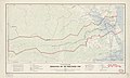 Map of the DMZ from 1957
 -
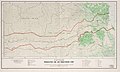 Map of the DMZ from 1966


See also
- 1st Searchlight Battery (United States)
- Clear Path International - an American NGO assisting victims of bombs and landmines left over from the Vietnam Warin Central Vietnam
- Demilitarized zone
- Hien Luong Bridge
- Korean Demilitarized Zone
- McNamara Line
- Inner German border and Berlin Wall
References
- ^ a b c d e "International Boundary Study No. 19 – Vietnam – "Demarcation Line"" (PDF). US Department of State. Retrieved September 21, 2020.
- ^ "17th parallel". Encyclopedia Britannica. Retrieved September 21, 2020.
- ISBN 978-1-481219-46-4. NVA and VC Order of Battle information is located on pages 114-127
External links
- Archive.org: Blurry Travel Guide to the DMZ — with photos.
- Honan.ne: Photos of DMZ
- Washington Post map of the DMZ
16°54′N 107°00′E / 16.9°N 107.0°E
| National | |
|---|---|
| Other | |