
Visočica (mountain)
| Visočica | |
|---|---|
| Височица | |
 | |
| Highest point | |
| Elevation | 1,974 m (6,476 ft) |
| Coordinates | 43°34.797′N 18°11.391′E / 43.579950°N 18.189850°E |
| Geography | |
 Visočica Location in BiH | |
| Location | |
| Parent range | Dinaric Alps |
Visočica (Serbian Cyrillic: Височица) is a mountain range in central Bosnia and Herzegovina. Geologically, Visočica is part of the Dinaric Alps and formed largely of secondary and tertiary sedimentary rock, mostly limestone and dolomite. Due to subterranean non-porous geological layers, the typical karst characteristics of the nearby Herzegovina mountains are relatively absent in Visočica, resulting in enough water sources, even at heights around 1500–1700 m. Springtime lakes, though, tend to dry out soon towards the summer. Some smaller streams source from these mountains as tributaries to its bordering rivers: the Ljuta in the east, the Rakitnica on its northern and western slopes and the Neretva towards the south. Notable peaks are Džamija (1974 m.), Vito (1960 m.), Veliko Ljeljen (1963 m.), Crveni Kuk (1733 m.) and Veliko Toholj (1837 m.).
Skiing and hiking
The Visočica mountains were on the edges affected by the heavy combat that was going on around the Treskavica and Neretva frontlines during the
Gallery
-
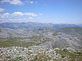 View from Dzamija summit
 -
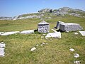 Stećci at Jezera necropolis
 -
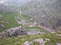 View from Crveni Kuk (1733 m)


.JPG)
Stećci
On several sites within Visočica
References
- ^ BiH Mine Action Centre (Annually updated) Mine Map
- ^ Gomez pp. 143-146
- ^ More info on the Vrela Tusila mountain hut at the site of its owning club PD "Treskavica": http://www.pdtreskavica.ba/
- ^ Gomez pp. 16-19
- Glavaticevo
- Sources
Gomez, Matias (2005). Forgotten Beauty: A Hiker's Guide to Bosnia and Hercegovina's 2000 Metre Peaks, and Other Selected Adventures. Sarajevo: Buybook.
External links
- Summitpost.org page on Visocica
- List of BiH mountain huts
- Site of local Mountain Club
- About Stecci in general
| Authority control databases: National |
|---|