
Vrbnik
Vrbnik | |
|---|---|
UTC+2 (CEST) | |
| Postal code | 51516 |
| Area code | 051 |
| Website | opcina-vrbnik |
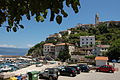
Vrbnik (Italian: Verbenico, German: Vörbnick) is a village and a municipality on the east coast of the island of Krk. The village is perched on a limestone outcropping 50 m above the Adriatic Sea.
Vrbnik is naturally separated from mainland Croatia by the Vinodol Channel, where the towns of Crikvenica and Novi Vinodolski can be observed across the sea. Since 1980 the island has been connected to mainland Croatia via the Krk Bridge.
Vrbnik has a long history of 900 years, it was an important Frankopan castle, and a Glagolitic and religious center. [3]
Originally a walled town, Vrbnik was established in medieval times. According to the
Culture
The Vrbnik Statute (Croatian: Vrbnički statut) was written in 1388 and confirms the status of Vrbnik as an administrative and political center. The town is also known through the folk song "Verbniče nad moren" or Verbniče nad moru" (Oh Vrbnik over the Sea), sung as far away as White Carniola in Slovenia.
Places of cultural significance include the Vitezić library, the Gothic Chapel of the Rosary and the Chapel of St. John in the Parish Church of the Assumption, and a collection of ancient manuscripts and
Vrbnik is known for its indigenous varietal of white wine called Žlahtina.
Vrbnik also claims to contain the world's narrowest street — Ulica Klančić is about 40–50 cm (1.3–1.6 ft) wide.[4][5][6]
Notable residents
- Saint Jerome of the Croats
- Zlatko Sudac - Roman Catholic Priest, known for his Stigmata
Photo gallery
-
 Vineyards
 -
 Harbour
 -
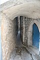 Klančić - one of the narrowest streets in the world, 40 cm (16 in)


-
 View from the harbour
 -
 Bell Tower of the Church of the Assumption of Mary
 -
 View over channel to Crikvenica


-
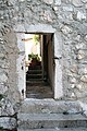 Gate in the wall
 -
 Traditional dress
 -
 View of Garica


References
- Wikidata Q119585703.
- ^ a b "Population by Age and Sex, by Settlements, 2021 Census". Census of Population, Households and Dwellings in 2021. Zagreb: Croatian Bureau of Statistics. 2022.
- ^ "VRBNIK | Vrbnik". vrbnik.hr (in Croatian). 2017-11-15. Retrieved 2023-05-25.
- ^ "Vrbnik ima najužu ulicu na svijetu". Hotel Argentum.
- ^ "Webcam Vrbnik". www.hike.uno.
- ^ "Najwęższa ulica świata i nurkowanie we Vrbnik". September 2, 2018.
External links
- Map of Krk and of the city of Vrbnik
- Tourist destinations on Krk, including Vrbnik
- Cultural information on Krk, including Vrbnik
- Municipality of Vrbnik
Subdivisions of Primorje-Gorski Kotar County | ||
|---|---|---|
| Cities and towns |  | |
| Municipalities | ||
| International | |
|---|---|
| National | |