
Ware Place, South Carolina
Ware Place, South Carolina | ||
|---|---|---|
FIPS code 45045 | | |
| GNIS feature ID | 2629839[2] | |
Ware Place is a
2010 United States Census, the population was 228.[5]
Geography
Ware Place is located at 34°37′40″N 82°23′27″W / 34.62778°N 82.39083°W (34.624718, -82.384822).[4] These coordinates place the CDP on the southwestern side of the county, near the border with Anderson County.
According to the United States Census Bureau, the CDP has a total land area of 0.917 square mile (2.37 km2) and a total water area of 0.001 square mile (0.003 km2).[4]
Demographics
| Census | Pop. | Note | %± |
|---|---|---|---|
| 2020 | 273 | — | |
| U.S. Decennial Census[6] | |||
References
- ^ "ArcGIS REST Services Directory". United States Census Bureau. Retrieved October 15, 2022.
- ^ a b U.S. Geological Survey Geographic Names Information System: Ware Place, South Carolina
- ^ "Census Population API". United States Census Bureau. Retrieved October 15, 2022.
- ^ a b c "US Gazetteer files: 2010, 2000, and 1990". United States Census Bureau. February 12, 2011. Retrieved April 23, 2011.
- ^ See http://factfinder.census.gov for population numbers and for municipality and CDP lists in the 2010 Census.
- ^ "Census of Population and Housing". Census.gov. Retrieved June 4, 2016.
Municipalities and communities of Greenville County, South Carolina, United States | ||
|---|---|---|
| Cities | 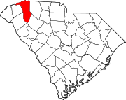 | |
| CDPs | ||
| Other communities | ||
| Footnotes | ‡This populated place also has portions in an adjacent county or counties | |
| ||
This South Carolina state location article is a stub. You can help Wikipedia by expanding it. |