
Weingarten (Baden)
You can help expand this article with text translated from the corresponding article in German. (February 2009) Click [show] for important translation instructions.
|
Weingarten | |
|---|---|
 | |
 Coat of arms | |
Location of Weingarten (Baden) within Karlsruhe district  | |
 Weingarten  Weingarten | |
| Coordinates: 49°3′5″N 8°31′50″E / 49.05139°N 8.53056°E | |
| Country | Germany |
| State | Baden-Württemberg |
| Admin. region | Karlsruhe |
| District | Karlsruhe |
| Government | |
| • Mayor (2018–26) | Eric Bänziger[1] |
| Area | |
• Total | 29.40 km2 (11.35 sq mi) |
| Elevation | 144 m (472 ft) |
| Population (2022-12-31)[2] | |
• Total | 10,534 |
| • Density | 360/km2 (930/sq mi) |
| Time zone | UTC+01:00 (CET) |
| • Summer (DST) | UTC+02:00 (CEST) |
| Postal codes | 76356 |
| Dialling codes | 07244 |
| Vehicle registration | KA |
| Website | www.weingarten-baden.de |
Weingarten (Baden) (German: [ˈvaɪnɡaʁtn̩] ⓘ) is a municipality in the district of Karlsruhe in southwestern Germany, situated at the transition from the Kraichgau to the Rhine valley. Its name means wine garden in German. Weingarten is located on the Bertha Benz Memorial Route.
While remains of a settlement from
The population is about two thirds
The village has its own elementary and secondary school; additional schools are in the neighbouring cities of Karlsruhe, Bruchsal, and Stutensee.
The village's main industries are wine and fruit production, gastronomy, and wood, chemical, and metal production.
For recreation, there are sports fields, an indoor swimming pool, a recreational lake, and the nature reserve Weingartener Moor. Also part of the municipality are the settlements Sallenbusch and Sohl in the Kraichgau hills, and Waldbrücke on the plain. The settlement of Sallenbusch was founded in June 1951 and constructed with the aid of U.S. soldiers. The first settlers arrived in July 1952.
-
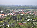 view from the hills
 -
 railway station
 -
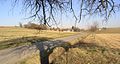 Sallenbusch
 -
 Catholic (left) and Lutheran (right) churches
 -
-
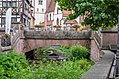 Walzbach
 -
 vineyards and cemetery
 -
 Memorial tower (Wartturm)


_Catholic_and_Lutheran_churches.jpg)
_Walzbach.jpg)
_vineyards_and_cemetery.jpg)

References
- ^ Aktuelle Wahlergebnisse, Staatsanzeiger, accessed 13 September 2021.
- Statistisches Landesamt Baden-Württemberg. June 2023.
External links
- Official website
 (in German)

| International | |
|---|---|
| National | |