
Wittmoor bog trackway

The Wittmoor bog trackway is the name given to each of two historic corduroy roads, trackway No. I being discovered in 1898 and trackway No. II in 1904[1] in the Wittmoor bog in northern Hamburg, Germany. The trackways date to the 4th and 7th century AD, both linked the eastern and western shores of the formerly inaccessible, swampy bog. A part of the older trackway No. II dating to the period of the Roman Empire is on display at the permanent exhibition of the Archaeological Museum Hamburg in Harburg, Hamburg.[2][3]
Location

Both bog trackways are located in the Wittmoor bog in the Hamburg districts of Duvenstedt, Lemsahl-Mellingstedt and the Norderstedt district of Glashütte in Schleswig-Holstein. Both trackways have been disturbed by historical peat cutters. In 1898 Ludwig Frahm, a local school teacher and historian followed a hint from Hinrich Mohr, a carpenter from Poppenbüttel, showing him the location of what he called a Russian causeway which is actually trackway No. I.[4][5] In 1900 Frahm excavated a few planks of the trackway, publishing his findings in 1901 and 1913. The two bog trackways found in Wittmoor were excellently preserved due to the moist, peaty soil.[6]
Bog trackway No. I

Bog trackway I (location: 53°42′10″N 10°04′18″E / 53.702829°N 10.0717169°E
Bog trackway No. II

Bog trackway No. II (location: 53°42′00″N 10°04′10″E / 53.699984°N 10.069399°E
-
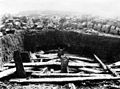 Excavation situation in the 1930s
 -
 Detail of the pile displacement II in the 1930s
 -
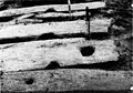 Mortise in a threshold in the 1930s


Interpretation
The discovery of the two bog trackways disproved the old doctrine that such bog trackways only occurred south of the river Elbe.[5] They show that in earlier times, a lively exchange between the western and eastern shores of the marshland occurred, and that the routes were considered so important that a significant logistical and substantive effort was expended to build paths through the marsh rather than circumvent the area. No archaeological evidence for settlements have been detected belonging to the bog trackways.[10]
References
- ^ The numbering of the trackways No. I for the younger northern one and No. II for the older southern one follows the local archive file of Archaeological Museum of Hamburg corresponding to early publications, in contrast to that Schindler uses a different numbering in his publication.
- ^ Topic Mobility, Show case no. 80.
- ^ ISBN 978-3-931429-24-9.)
{{cite book}}: CS1 maint: location missing publisher (link - ^ a b Frahm, Ludwig (1930). "Wie wir den ersten Bohlenweg auf dem Wittmoor fanden". Jahrbuch des Alstervereins: 30 Jahre Alster-Verein (in German). 18. Hamburg-Wandsbek: Christiansen: 26–29.
- ^ a b Ziesche, Ferdinand (November 2006). "Der Forscherdrang des Ludwig Frahm - Entdeckung im Wittmoor" (PDF). Alstertal-Magazin (in German): 118–119. Retrieved 2012-09-19.
- ^ a b c d e Schindler, Reinhard (1960), Die Bodenaltertümer der Freien und Hansestadt Hamburg (in German), Hamburg: Hans Christians, pp. 119–121, Annex 1
- ISSN 0179-9703.
- ISSN 0173-0886.
- ^ Thieme, Wulf. H. Linde-Lebke (ed.). "Alte Wege über das Moor". Von der einstigen Tangstdter Heide zum heutigen Norderstedter Stadtteil Glashütte, 100 Jahre 1896-1996 (in German): 23–25.
- ^ Thieme, Wulf (2011). Jürgen Ehlers (ed.). "9. Ur- und Frühgeschichte" (PDF). Geologische Karte von Hamburg 1:25 000 - Erläuterungen zu Blatt Nr. 2326 Fuhlsbüttel (in German). Hamburg: Geologisches Landesamt: 100–102. Retrieved 2012-09-19.