
Wurm
| Wurm | |
|---|---|
 Zwei Mühlen on the Wurm between Schloss Rimburg (D) and the village of Rimburg (NL) | |
 Course of the Inde, Wurm and Rur | |
| Location | |
| Country | Germany |
| State | North Rhine-Westphalia |
| Reference no. | DE: 2828 |
| Physical characteristics | |
| Source | |
| • location | South of Aachen |
| • coordinates | 50°44′15″N 6°05′16″E / 50.7374694°N 6.0877111°E |
| • elevation | 265 m above sea level (NN) |
| Landmarks |
|
The Wurm (German pronunciation: Rur.
Geography
The Wurm is a left (western) tributary of the
.The sources of the Wurm are several brooks in the forests southwest of
Rur near Heinsberg
.
Other towns on the river Wurm are Würselen, Übach-Palenberg and Geilenkirchen.
The name Wurm is thought to originate from the German word warm (same meaning in English), as the source brooks were fed from the thermal springs in Aachen.
Gallery
-
 Meanders of the Wurm near Kohlscheid
 -
 Wilderness
 -
 Rimburg Castle near Übach-Palenberg
 -
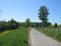
 Watermill near Zweibrüggen
 -
 Castle Trips, Geilenkirchen
 -
 Wurm valley near Süggerath
 -
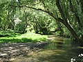
 Wurm at Gut Kalkofen, Aachen


See also
- Rur Basin
- List of rivers of North Rhine-Westphalia
 Media related to Wurm at Wikimedia Commons
References
- Kalinka, G.; Schütten, J. (1993). Naturraum Wurmtal. Wurmverlag Herzogenrath. ASIN B0029ZWV8I.
| International | |
|---|---|
| National | |