
Xingcheng Haibin National Park
| Xingcheng Haibin National Park | |
|---|---|
| 兴城海滨 | |
 Xingcheng Waterfront | |
 Location of Xingcheng Haibin NP | |
| Location | Liaoning |
| Nearest city | Xingcheng |
| Coordinates | 40°40′0″N 120°50′0″E / 40.66667°N 120.83333°E |
Xingcheng Haibin National Park (
Qin Shihuang.[1] The park's name may also be translated as "Xingcheng Seaside Resort". The main beach is reachable by bus; Juhua Island is 9 km offshore, and is accessible by ferry.[2] Although designated as a national park, Xingcheng Haibin is not listed as a "protected area" in the World Database of Protected Areas (WDPA).[3]
-
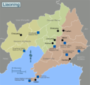 Xingcheng Haiban NP is located on the west side ofLiaoning Province
 -
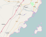 Xingcheng, with Juehua Island offshore in Liaodong Bay


External links
References
- ^ "Ancient City Xingcheng". Liaoning Gateway. Retrieved 2010-01-05.
- ^ "Xingchen Seaside Resort". National Park China. 2015. Retrieved 2015-12-13.
- ^ Protected Planet, Interactive Map of World Database of Protected Areas, Protected Planet, a joint venture of IUCN and UNEP