Yanamarey
| Yanamarey | |
|---|---|
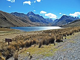
 Lake Querococha and Mount Pucaraju (center-left). In the background the Yanamarey glacier is visible. | |
| Highest point | |
| Elevation | 5,237 m (17,182 ft) |
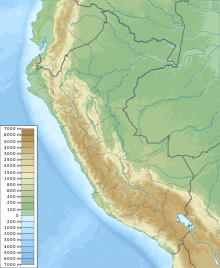
| Coordinates | 9°39′40″S 77°15′40″W / 9.66111°S 77.26111°W |
| Geography | |
| Location | Ancash, Peru |
| Parent range | Cordillera Blanca |
| Climbing | |
| First ascent | Yanamarey N: 1-1967 via N. ridge. Yanamarey S: 1-1965 via S. slopes.[1] |
YanamareyAncash. Yanamaray lies east of Pucaraju and northeast of Lake Querococha, between Matashcu in the north and Cahuish in the south.[7]
The Yanamaray River originates west of the mountain. It provides Qiruqucha with the melt water of the Yanamarey glacier before it empties into Santa River.[2][7]
Annual observations have shown that the Yanamarey glacier has been rapidly retreating over the last years.[8]
See also
References
- ^ Jill Neate, Mountaineering in the Andes, RGS-IBG Expedition Advisory Centre, 2nd edition, May 1994: "Yanamarey Group: Yanamarey (Yanamarey Norte ) 5262m: 1-1967 via N. ridge. Yanamarey Sur 5220m: 1-1965 via S. slopes."
- ^ ISBN 3-937530-05-3.
- ^ ISBN 9780953608720.
- ^ Díaz, Felipe (2008–2009). Carta Turística. Cordilleras Blanca, Negra, Huayhuash y Callejón de Huaylas.
- ^ Qhichwa Suyup Simi Pirwan Diccionario de la Nación Quechua, Consejo Educativo de la Nación Quechua "CENAQ"
- ^ Teofilo Laime Ajacopa (2007). Diccionario Bilingüe: Iskay simipi yuyayk’anch: Quechua – Castellano / Castellano – Quechua (PDF). La Paz, Bolivia: futatraw.ourproject.org.
- ^ a b c d Peru 1:100 000, Recuay (20-i). IGN (Instituto Geográfico Nacional - Perú).
- ^ Jeffrey T. Bury et al., Glacier recession and human vulnerability in the Yanamarey watershed of the Cordillera Blanca, Peru, Climatic Change (2011) 105:179–206

