
Yushan National Park
| Yushan National Park | |
|---|---|
Yushan (Mount Jade) is Taiwan's tallest mountain at 3,952m (12,966 ft) | |
 Location of Yushan National Park | |
| Location | Nantou County, |
| Nearest city | Shuili |
| Coordinates | 23°28′12″N 120°57′26.16″E / 23.47000°N 120.9572667°E |
| Area | 103,121 ha (398.15 sq mi) |
| Established | April 10, 1985 |
| Visitors | 1,349,281 (in 2005) |
Yushan National Park (
Because of its remote location and entry control, Yushan National Park is not among the most visited national parks in Taiwan. Even so, the park attracted 1,044,994 visitors in 2015.[3]
Geology
Taiwan, which owes its existence to the power of plate tectonics, remains a place of regular seismic activity. Examples of geological features such as fault lines, joints, and folding can be seen throughout Yushan National Park:
- Great Precipice (大峭壁) — Great Precipice (23.4683339 120.9396649) is located 1.2 km before Paiyun Lodge (排雲山莊) on the Yushan Trail. A precipitous cliff with fossils of ancient marine species and a few wavy marks in the rock can still remind us of its oceanic past.
- Scree slopeat the foot of Main Peak
- Fault scarp in Laonong (荖濃) between Main Peak and Batongguan (八通關)
- Fuzi Cliff (父子斷崖) and Guanshan Cliff (關山斷崖)
The Southern Cross-Island Highway and the Yushan Scenic Highway both offer countless opportunities to witness the area's special geological features.[4]
Hydrology
Yushan is an important
Alpine lakes such as Dashueiku (大水窟), Tafen Pond (塔芬池), Jiaming Lake (嘉明湖), and Tienchih (天池) are formed from rain and melting snows in the shadows of surrounding mountain peaks. These lakes provide both visitors and animals precious water from the mountains. However, the ecosystem around them is fragile and needs further protection.[citation needed]
Flora
Yushan National Park is well known for its diverse climate zones and rich
Differences in
With increasing elevation, there are the following six vegetation zonations in the park:
| Altitude | Characteristics | |
|---|---|---|
| Broadleaf Forest Zone | Below 1,800 metres (5,906 ft) | The broadleaved forest is mainly dominated by trees of the tree layer is composed of members of the Fagaceae, such as Cyclobalanopsis morii, Castanopsis carlesii 小红栲 and Lithocarpus amygdalifolius 杏叶柯. The ground layer plants are also plentiful and include ferns and bracken .
|
| Chamaecyparis Zone | 1,800 metres (5,906 ft) — 2,500 metres (8,202 ft) | In this zone, it grows some precious Chamaecyparis pure forests. |
| Tsuga Chinensis Zone | 2,500 metres (8,202 ft) — 3,500 metres (11,483 ft) | In this zone, the coniferous trees are represented by Chamaecyparis formosensis,Chamaecyparis obtusa var. formosana (台湾扁柏), Taiwan cryptomerioides Hayata, Chunninghamia konishii Hayata and Pseudotsuga wilsoniana Hayata;and the deciduous tree by Acer morrisonensis Hayata and Acer serriulatum Hayata. Chamaecyparis formosensis and Chamaecypairs obtusa var. formosana are commonly called cypress .
|
| Abies Kawakamii Zone | About 3,530 metres (11,581 ft) | Groups of Abies kawakamii grow on the western slope of Yushan. |
| Subalpine Shrub Zone | 3,500 metres (11,483 ft) — 3,800 metres (12,467 ft) | Dwarf plants, which grow prostrate and leeward, are the dominant vegetation types of this area. |
| Alpine Herbaceous Zone | Above 3,800 metres (12,467 ft) | When summer comes, herbaceous plants, such as Adenophora uehatae Yamamoto (高山沙參),Leontopodium microphyllum Hayata, Sedum morrisonensis and Gentiana arisanensis Hayata, give rise to colorful flowers in this area, |
Fauna
The park is home to a large variety of birds, mammals, reptiles, amphibians, and butterflies. Between the months of March and May, visitors have the chance to see processions of butterflies fluttering through mountain valleys. In the following table, it shows total different kinds of animals found in the park:[6]
| Mammals | Reptiles | Amphibians | Insects | Birds | Fishes |
|---|---|---|---|---|---|
| 50 | 18 | 13 | 780 | 151 | 12 |
In the past, many of these species became endangered due to over-hunting; but with the establishment of the Yushan National Park, they are gradually making a comeback. Larger mammals such as the
The National Park is an important nesting ground for the Taiwanese population of Mountain hawk-eagle.[7]
Cultural heritage
Prehistoric relics, such as stone tools and pottery, found in the Wangshiang (望鄉) and Dongpu (Tungpu;東埔) areas, provide evidence of early human occupation. The
Eco-tourism
To promote
| Foot paths (metres) | Parking lots | Pedestrian protective rails (metres) | Suspension bridges | Rest rooms | Sewage treatment plants | Tourist centers | Training centers |
|---|---|---|---|---|---|---|---|
| 39,880 | 17 | 1,111 | 18 | 13 | 2 | 3 | 1 |
For public safety, a lot of bridges and wooden pathways have been installed on difficult terrain.
There are three visitor centers in the park:
Pictures
-
 Laonung River at the northeastern side of Yushan
 -
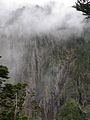
 Sea of clouds near Yushan
 -
 Sea of clouds on Yushan Trail
 -
 Sea of clouds near Tatajia Anbu on Yushan Trail
 -
 Sun rise at Yushan
 -
 On top of the world
 -
 Yushan Range, eastern side view


.jpg)
See also
References
- ^ Taiwan's National Park Website. Archived May 12, 2007, at the Wayback Machine
- ^ "Request Rejected" 各國家公園基本資料表 (PDF) (in Chinese). Construction and Planning Agency, Ministry of the Interior, R.O.C.(Taiwan). June 6, 2014. Retrieved October 23, 2014.[permanent dead link]
- ^ "各國家公園遊憩據點遊客人數統計表" (PDF). National Parks of Taiwan. Construction and Planning Agency, Ministry of the Interior. 2015-12-31. Retrieved 2016-08-29.[permanent dead link]
- ^ a b Yushan National Park Website. Archived July 15, 2009, at the Wayback Machine
- ^ "Hydrology-Yushan National Park". Archived from the original on October 14, 2007. Retrieved September 5, 2009.
- ^ Survey of biodiversity in Taiwan's National Parks.
- ^ Pin-chuan, Liu; Madjar, Kayleigh (18 July 2021). "Footage of hawk eagles in Yushan gives opportunity". www.taipeitimes.com. Taipei Times. Retrieved 18 July 2021.
- ^ Public Facilities in Taiwan's National Parks.
External links
| Authority control databases: National |
|---|