
Yangmingshan
| Yangmingshan National Park | |
|---|---|
Seven Star Mountain with hot springs on the side | |
 Location of Yangmingshan National Park | |
| Location | Taiwan |
| Nearest city | Taipei (majority of park within city limits) |
| Coordinates | 25°10′39″N 121°32′51″E / 25.17750°N 121.54750°E |
| Area | 113.38 km2 (43.78 sq mi)[1] |
| Established | September 16, 1985 |
| Yangmingshan | |
|---|---|
Hanyu Pinyin | Yángmíngshān Guójiā Gōngyuán |
| Southern Min | |
| Hokkien POJ | Iûⁿ-bêng-soaⁿ Kok-ka Kong-hn̂g |
Yangmingshan National Park is one of the
History
This mountain range was originally called "Grass Mountain" (
Officials during this period were worried about thieves stealing sulfur from the rich sulfur deposits in the area, so they would regularly set fire to the mountain. Thus, only grass and no trees could be seen.In 1950, President
Landscape and geology
Unlike most other national parks, the Yangmingshan National Park has a lower elevation. Although the park's elevation ranges from only 200–1120 meters, beautiful landscapes such as ridges, valleys, lakes, waterfalls, and basins are abundant. Andesite rocks make up most of the area's geology.[5]
Xiaoyoukeng
Xiaoyoukeng (
Hiking trails to Seven Star Mountain are accessible from the Xiaoyoukeng parking lot. The top of the trail is 1,120 meters above sea level, which is the highest peak of Taipei City. The Xiaoyoukeng trail can connect to Qixing Park, Menghuan Pond, and Lengshuikeng. The trail also connects to the visitor center, Yangmingshan Second Parking Lot, and the Yangmingshan Bus Station.<[6]


Flora and fauna
Due to the effects of post-volcanic activity and precipitation, soil in the region is highly acidic. With the influence of the northeast monsoon and the area's microclimates, winter temperatures are much lower than in the surrounding areas.
Climate
Yangmingshan has a
The following climate data is for the Anbu weather station. Other places in the national park may have different temperatures.
| Climate data for Anbu, Yangmingshan National Park (1991-2020 normals, extremes 1943-present) | |||||||||||||
|---|---|---|---|---|---|---|---|---|---|---|---|---|---|
| Month | Jan | Feb | Mar | Apr | May | Jun | Jul | Aug | Sep | Oct | Nov | Dec | Year |
| Record high °C (°F) | 24.5 (76.1) |
27.0 (80.6) |
27.7 (81.9) |
28.8 (83.8) |
29.9 (85.8) |
31.0 (87.8) |
31.9 (89.4) |
32.0 (89.6) |
31.4 (88.5) |
30.7 (87.3) |
27.5 (81.5) |
25.7 (78.3) |
32.0 (89.6) |
| Mean daily maximum °C (°F) | 13.3 (55.9) |
14.6 (58.3) |
17.1 (62.8) |
20.5 (68.9) |
23.2 (73.8) |
25.6 (78.1) |
27.4 (81.3) |
26.8 (80.2) |
24.3 (75.7) |
20.5 (68.9) |
18.1 (64.6) |
14.6 (58.3) |
20.5 (68.9) |
| Daily mean °C (°F) | 10.3 (50.5) |
11.2 (52.2) |
13.2 (55.8) |
16.6 (61.9) |
19.6 (67.3) |
22.2 (72.0) |
23.4 (74.1) |
23.0 (73.4) |
21.1 (70.0) |
17.9 (64.2) |
15.4 (59.7) |
11.8 (53.2) |
17.1 (62.9) |
| Mean daily minimum °C (°F) | 8.1 (46.6) |
8.7 (47.7) |
10.3 (50.5) |
13.7 (56.7) |
17.2 (63.0) |
19.9 (67.8) |
20.9 (69.6) |
20.7 (69.3) |
19.1 (66.4) |
16.3 (61.3) |
13.5 (56.3) |
9.8 (49.6) |
14.9 (58.7) |
| Record low °C (°F) | −3.7 (25.3) |
−2.4 (27.7) |
−2.0 (28.4) |
1.0 (33.8) |
8.1 (46.6) |
11.4 (52.5) |
16.6 (61.9) |
15.5 (59.9) |
12.6 (54.7) |
6.0 (42.8) |
1.1 (34.0) |
−1.6 (29.1) |
−3.7 (25.3) |
| Average precipitation mm (inches) | 296.7 (11.68) |
291.3 (11.47) |
246.7 (9.71) |
222.3 (8.75) |
334.0 (13.15) |
341.1 (13.43) |
230.9 (9.09) |
400.8 (15.78) |
724.6 (28.53) |
683.6 (26.91) |
502.5 (19.78) |
422.6 (16.64) |
4,697.1 (184.92) |
| Average precipitation days (≥ 0.1 mm) | 21.2 | 18.3 | 18.3 | 15.8 | 15.6 | 14.3 | 9.7 | 13.1 | 16.3 | 20.1 | 20.9 | 21.4 | 205.0 |
| Average relative humidity (%)
|
92.1 | 91.5 | 89.8 | 88.4 | 87.5 | 87.8 | 85.8 | 87.5 | 89.0 | 91.0 | 92.0 | 92.2 | 89.6 |
| Mean monthly sunshine hours | 59.0 | 58.7 | 78.1 | 77.2 | 79.6 | 85.2 | 138.4 | 124.7 | 96.0 | 61.5 | 51.4 | 46.6 | 956.4 |
| Source: Central Weather Bureau[14][15][16][17][18] | |||||||||||||
Historical and cultural sites
- Chinese Culture University
- National Assembly of the Republic of China
- Grass Mountain Chateau - Summer residence of Chiang Kai-shek
- Guangfu Building - Built in 1971 in Northern Chinese palace-style architecture to commemorate the Xinhai Revolution.[19]
- Home and grave of famous writer Lin Yutang
- Yangmingshuwu - Former KuomintangParty Archives
- Yangmingshan American Military Housing
- Yangmingshan No.1 Public Cemetery - Contains the graves of Sun Fo and Homer Lea.[20]
- Taipei European School
- Tomb of Puru, painter, educator, and cousin of China's last emperor Puyi.[21]
- Tomb of Yu Youren
- Wuchih Mountain Military Cemetery
Gallery
-
 Qingtiangang.
 -
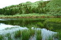 Dream Lake.
 -
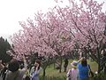 Cherry Blossom
 -
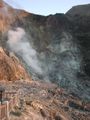 Closer view of fumarole on Seven Star Mountain.
 -
 Chung-Shan Building in Yangmingshan.
 -
 Chinese Pavilion andCherry Blossom.
 -
 Guangfu Building.
 -
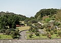 A park near the entrance.
 -
 Statue of Chiang Kai-shek in the park.
 -
 Yangmingshan hot springs


See also
- List of national parks in Taiwan
- Tatun Volcano Group
- Qixing Mountain (Taipei)
References
- ^ "Request Rejected" 各國家公園基本資料表 (PDF) (in Chinese). Construction and Planning Agency, Ministry of the Interior, R.O.C.(Taiwan). June 6, 2014. Retrieved October 23, 2014.[permanent dead link]
- ^ a b Barron, James (April 4, 2020). "Shadows at Yangmingshan". Taipei Times. Retrieved April 5, 2020.
- ^ ivil Affairs Handbook: Taiwan (Formosa), Taihoku Province. United States Office of the Chief of Naval Operations. November 1, 1944. p. 180. Archived from the original on September 10, 2008.
- ^ "Tourists will surpass million mark by 1976". Free China Review. September 1, 1972. Retrieved April 5, 2020.
- ^ [1] [permanent dead link]
- ^ a b "Senic Spots: Xiaoyoukeng". Yangmingshan National Park. 2012. Archived from the original on April 26, 2017.
- ^ Gardner, Dinah (May 2, 2022). "How Taipei discovered an active volcano on its doorstep". Future Planet. BBC.
- ^ "Tamsui Scenery in detail: Xiaoyoukeng". Tamkang University. Archived from the original on May 8, 2022.
- ^ Liao, George (October 29, 2017). "A hike to Taipei City's highest mountain". Taiwan News. Archived from the original on November 7, 2017.
- ^ "Yangmingshan". Archived from the original on January 30, 2018. Retrieved December 10, 2018.
- ^ "A Bird-watching Trip in Yangmingshan National Park". Archived from the original on June 12, 2010.
- ^ "Archived copy" (PDF). Archived from the original (PDF) on March 5, 2012. Retrieved April 7, 2010.
{{cite web}}: CS1 maint: archived copy as title (link) - ^ 太厲害!擎天崗的牛 乖乖跟「他」走!. The Liberty Times. Retrieved on May 08, 2017
- Central Weather Bureau. Retrieved February 2, 2024.
- ^ "氣象站各月份最高氣溫統計" (PDF) (in Chinese). Central Weather Bureau. Archived from the original (PDF) on May 21, 2023. Retrieved February 2, 2024.
- ^ "氣象站各月份最高氣溫統計(續)" (PDF) (in Chinese). Central Weather Bureau. Archived from the original (PDF) on May 21, 2023. Retrieved February 2, 2024.
- ^ "氣象站各月份最低氣溫統計" (PDF) (in Chinese). Central Weather Bureau. Archived from the original (PDF) on May 21, 2023. Retrieved February 2, 2024.
- ^ "氣象站各月份最低氣溫統計(續)" (PDF) (in Chinese). Central Weather Bureau. Archived from the original (PDF) on May 21, 2023. Retrieved February 2, 2024.
- ^ "Guangfu Building Overview". Archived from the original on July 21, 2011. Retrieved January 27, 2011.
- ^ YC-Wang, Daal. "荷馬李將軍夫婦靈骨厝葬 - VCenter:影音分享網站(Video Sharing Website)".
- ^ "個人簡歷". Archived from the original on March 20, 2012. Retrieved February 9, 2011.
External links
 Media related to Yangmingshan National Park at Wikimedia Commons
 Yangmingshan travel guide from Wikivoyage
- Official website
| International | |
|---|---|
| National | |