
Zama, Kanagawa
Zama
座間市 | |
|---|---|
.jpg) Zama City Hall | |
|
Sunflower | |
| • Bird | Japanese tit |
| Phone number | 046-255-1111 |
| Address | 1-1-1 Midorigaoka, Zama-shi, Kanagawa-ken 252-8566 |
| Website | Official website |

Zama (座間市, Zama-shi) is a city located in Kanagawa Prefecture, Japan. As of 1 June 2021[update], the city had an estimated population of 130,667 and a population density of 7,400 persons per km2.[1] The total area of the city is 17.58 square kilometres (6.79 sq mi). The city hosts the
Geography
Located in central Kanagawa Prefecture, Zama is approximately 50 kilometers from the center of Tokyo and 20 kilometers from Yokohama. It is divided into an alluvial lowland along the Sagami River in the west and a plateau belonging to the Sagamino Plateau (Sagamihara Plateau) in the east. The Hikiji River, Mekushiri River, and the Hato River flow through Zama. The city is well known for its drinking water, which is cold in the summer and warm in the winter.[2]
Surrounding municipalities
Kanagawa Prefecture
Climate
Zama has a humid subtropical climate (Köppen Cfa) characterized by warm summers and cool winters with light to no snowfall. The average annual temperature in Zama is 14.4 °C. The average annual rainfall is 1632 mm with September as the wettest month. The temperatures are highest on average in August, at around 25.3 °C, and lowest in January, at around 3.6 °C.[3]
Demographics
Per Japanese census data,[4] the population of Zama has grown steadily over the past 70 years.
| Year | Pop. | ±% |
|---|---|---|
| 1950 | 11,810 | — |
| 1960 | 15,402 | +30.4% |
| 1970 | 56,727 | +268.3% |
| 1980 | 93,503 | +64.8% |
| 1990 | 112,102 | +19.9% |
| 2000 | 125,694 | +12.1% |
| 2010 | 129,436 | +3.0% |
| 2020 | 132,325 | +2.2% |
History
The area around Zama has been settled since prehistoric times, and
The area remained very rural until the coming of the
In September 1948, Zama regained its status as a town independent of Sagamihara. The local economy received a significant boost with the building of a Nissan automobile assembly plant in Zama in 1965, along with other industries. Zama became a city on November 1, 1971.
Government
Zama has a
Economy
After the Meiji era, mulberry fields and the raw silk industry dominated the local economy. Zama became heavily industrialized from the 1930s with production of equipment for the Japanese military, and this was followed in the 1950 and 1960s with automobile related production. However, with the economic recession in the 1990s Nissan production ended in 1995, and the economy of Zama suffered accordingly. The city has increasingly become a commuter town for nearby Sagamihara, Yokohama and Tokyo.
- Agriculture: 413 people (0.6%)
- Manufacturing: 18,978 people (29.8%)
- Service: 43,298 people (68.0%)
Education
Zama has 11 public elementary schools and six public middle schools operated by the city government. The city has three public high schools operated by the Kanagawa Prefectural Board of Education, and the prefecture also operates one special education school for the handicapped.
Transportation
Railway
Highway
Sister cities
Local attractions
- Zama Yatoyama Park
- Zama Park
- Himawari Park
- Kanigasawa Park
- Fujiyama Park
- Onsen (15 hot springs in the city)
Noted people from Zama
- Yokohama, Kanagawa)
- Alcvin Ryuzen Ramos, Shakuhachi Flute Player/Maker
- Ami Suzuki, Singer/Songwriter, Actress and Dancer
- Danny Lee Clark, Athlete, Television Personality, Author, Actor, and Producer
- Erina Mano, Actress and Singer
- Sagamihara, Kanagawa)
- Koyuki, Model and Actress
- Yokohama, Kanagawa)
- Naoya Inoue, Boxer, Super Bantamweight Champion
- Saki Shimizu, Singer (Originally from Tokyo)
- Sakura Oda, Singer
- Shinobu Ohno, Female Footballer
- Suzuka Ohgo, Actress
- Tomoko Ishimura, Voice Actress
Gallery
-
 The Hato River
 -
 Manhole cover depicting symbols of Zama
 -
 Manhole cover depicting sunflowers, a symbol of Zama
 -
 Neighborhood in the vicinity of Soubudai-mae train station
 -
 Vegetable plots near Midori-ga-oka neighborhood
 -
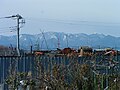 View of the distant mountains
 -
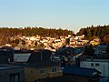 View of a neighborhood within a short walk of Soubudai-mae train station


References
- ^ "Zama city official statistics" (in Japanese). Japan.
- ^ Zama City Hall (ed.). 座間市特産品「ざまみず」アルミボトル缶大好評販売中!! (in Japanese). Retrieved March 11, 2016.
- ^ Hadano climate data
- ^ Hadano population statistics
External links
- Official Website (in Japanese)
| Yokohama |
| |||
|---|---|---|---|---|
| Kawasaki |
| |||
| Sagamihara |
| |||
| Core city | ||||
| Special cities | ||||
| Cities | ||||
| Districts | ||||
| International | |
|---|---|
| National | |
| Geographic | |