
Île d'Orléans
Native name: Île d'Orléans | |
|---|---|
Saint Lawrence River | |
| Area | 192.85 km2 (74.46 sq mi)[1] |
| Length | 34 km (21.1 mi)[2] |
| Width | 8 km (5 mi)[2] |
| Highest elevation | 150 m (490 ft)[2] |
| Administration | |
Canada | |
| Province | Quebec |
| Regional county | L'Île-d'Orléans |
| Demographics | |
| Population | 7,082 (2016)[1] |
| Pop. density | 37/km2 (96/sq mi) |
Île d'Orléans (French pronunciation:
It has about 7,000 inhabitants, spread over 6 villages.
The island is accessible from the mainland via the
Geography

The Island of Orleans is situated between the
The island is separated from the mainland by 2 channels; to the north-west is the Île d'Orléans Channel[5] and to the south-east is the Grands Voiliers Channel.[6]
Of irregular form with jagged coves and capes, the Island of Orleans is 34 kilometres (21 mi) long and 8 kilometres (5.0 mi) wide at the widest point. It is 75 kilometres (47 mi) in circumference, with a total surface area of 190 square kilometres (73 sq mi). It has a hilly relief, small valleys, and gradual crests that reach a maximum height of about 150 metres (490 ft) at Sainte-Pétronille and Saint-Laurent in the south.[2][1]
The main streams of Île d'Orléans are:[7]
- Chenal des Grands Voiliers (SE side of the island)
- Chenal de l'Île d'Orléans (NW side of the island)
- Rivière Dauphine (Saint-Jean)
- Rivière Lafleur (Saint-Jean)
- Rivière Maheu (Saint-Laurent)
- Ruisseau du Moulin (Saint-François)
- Rivière du Moulin (Saint-Laurent)
- Rivière du Moulin (Saint-Pierre)
- Rivière Pot au Beurre (Sainte-Famille)
- Rivière de la Savane
Administratively, the island is within Quebec's
|
|
. The entire island is part of the


History
The island had long been inhabited by
Early French settlers, mostly from
In 1744, colonists completed the 67 kilometres (42 mi) Chemin Royal (Royal Road), which encircles the entire island.[8] Jean Mauvide, a surgeon for the King of France, built the Manoir Mauvide-Genest in 1734 as his residence. In 1759, it was occupied by British General James Wolfe when his forces occupied the island shortly before the Battle of the Plains of Abraham during the Seven Years' War in which Britain was victorious.
In the 19th and early 20th century, several boatbuilding yards operated on the island, especially in Saint-Laurent-de-l'Île-d'Orléans. Together with the thriving fishing industry of that era, they gave the island a maritime character.[9]
In 1935 the Pont de l'Île was completed, and the bridge brought much more traffic. However, the island has maintained its pastoral image and historic character, with more than 600 buildings classified or recognized as heritage property. In 1990, the entire island was designated a National Historic Site of Canada.[3][2][8][10]
Today, the island is a mix of suburban communities and farms and is a popular destination for day trippers and bicyclists.
-
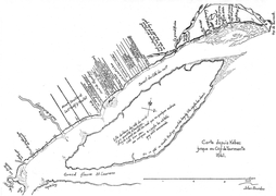 Map of Beaupré and Île d'Orléans, drawn in 1641 by Jean Bourdon
 -
 Map of the government of Quebec drawn in 1709 by Gédéon de Catalogne
 -

-
 Manoir Mauvide-Genest
 -
 Maison Drouin in Sainte-Famille
 -
 Mock-up door of make-believe l'Île-d'Orléans seigneurie


.jpg)


Economy
Since the days of the first French settlers, agriculture has been the main economic activity. Potatoes, strawberries, apples, blueberries, raspberries and maple syrup is produced. There is also
While the old trades of fishing and boat building have been abandoned, the island's rich cultural heritage and pastoral scenery has led to a flourishing tourism industry. It attracts more than 600,000 visitors each year. Numerous
- Sainte-Famille-de-l'Île-d'Orléans the church of the Sainte-Famille from 1743 and the interpretation centers Maison de nos Aïeux and Maison Drouin;
- Saint-François-de-l'Île-d'Orléans the observation tower, the beach and the chocolate factory on Île d'Orléans;
- Saint-Jean-de-l'Île-d'Orléans the café "La Boulange", the Catholic church, the promenade on the shore of the St. Lawrence and the Mauvide-Genest Manor (National Historic Site of the Canada);
- Saint-Laurent-de-l'Île-d'Orléans the "La Chalouperie" museum at the maritime park and the Île d'Orléans marina;
- Sainte-Pétronille the island's chocolate factory and the painter's house Horatio Walker;
- Saint-Pierre-de-l'Île-d'Orléans the Félix Leclerc space and the Bellevue with the giant sculpture of Félix Leclerc.
Also for years there has been a strong movement of the inhabitants of
Notable people
Félix Leclerc is buried in Saint-Pierre. There is the Espace Félix Leclerc, today a museum and performance hall, in his honor.
In art and culture
Several chansonniers have made reference to Île d'Orléans in their songs, in particular:
- Yves Duteil refers to the island in his song La langue de chez nous (Our language).
- Félix Leclerc will make a song of it : Le Tour de l'île (The Island Tour).
- Jean-Pierre Ferland refers to the island in Chanson pour Félix (Song for Félix)
- Sylvain Lelièvre refers to the island in his song Le fleuve (The river)
- Monique Leyrac refers to the island in her song La fille de l'île (The Island Girl)
- Tire le Coyote refers to the island in his song Calfeutrer les failles (Caulk faults)
Gallery
-
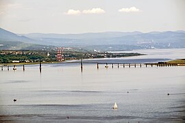 Panoramic view of the North shore, Saint-Laurent river, Île d'Orléans bridge
 -
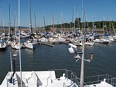 Île d'Orléans Marina
 -
 Museum La Chalouperie at "Parc maritime de Saint-Laurent" (English: Saint-Laurent Maritime Park)
 -
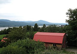 View of the north shore of the St. Lawrence River
 -
 The frozen St. Lawrence River at the Île d'Orléans bridge

.jpg)
.jpg)


See also
- Geography of Quebec
- List of islands of Quebec
- Maison Drouin
References
- ^ a b c "Census Profile, 2016 Census: L'Île-d'Orléans, Municipalité régionale de comté [Census division], Quebec". Statistics Canada. Retrieved December 12, 2019.
- ^ a b c d e f g "Île d'Orléans" (in French). Commission de toponymie du Québec. Retrieved 2009-10-27.
- ^ a b c d e f g "Welcome to Île d'Orléans". Île d'Orléans Tourism. Retrieved 2024-04-12.
- ^ "A river, estuaries, a gulf, the great hydrographic divisions" (PDF). Atlas of the St. Lawrence (in French). Atlas environnemental du Saint-Laurent. 1991. Retrieved 11 April 2024.
The width of the Lower Estuary varies from 24 km to Tadoussac 50 km to Pointe-des-Monts
- ^ "Chenal de l'Île d'Orléans". Geographical Names Data Base. Natural Resources Canada.
- ^ "Chenal des Grands Voiliers". Geographical Names Data Base. Natural Resources Canada.
- ^ Poirier, J. (1962). La toponymie de l'Ile d'Orléans. Cahiers de géographie du Québec, 6(12), 183–199S.
- ^ a b c "Discover the Island". Courtepointe et Cafe Association of B&Bs on the Island of Orleans. Retrieved 2009-10-29.
- ^ "Saint-Laurent-de-l'Île-d'Orléans (Municipalité)" (in French). Commission de toponymie du Québec. Retrieved 2009-10-26.
- ^ Île d'Orléans Seigneury. Canadian Register of Historic Places. Retrieved 31 March 2012.
Further reading
- Linda Arsenault et Sonia Landry (dir.), Les producteurs toqués de l'île d'Orléans. Farmers in Chef Hats, Éditions L. A. Communication, Québec, 2007 ISBN 9782980972102
- Louis-Édouard Bois, L'île d'Orléans: notes sur son étendue, ses premiers établissements, sa population, les mœurs de ses habitants, ses productions, A. Coté & Cie., 1895, 148 p.
- Hélène Bourque, Donald Dion et Brigitte Ostiguy, L’île d’Orléans, un enchantement, Éditions du Chien Rouge, Québec, 1999, 48 p. ISBN 9782922627008
- André Gaulin, et Norbert Latulippe, L’île d’Orléans, microcosme du Québec, Association québécoise des professeurs de français, Québec, 1984, 137 p.
- Collectif, « Dossier île d’Orléans : Le goût de l’île », Continuité, n° 73, été 1997, p. 17-51.
- Martin Fournier, Jean Mauvide : de chirurgien à seigneur de l’île d’Orléans au XVIIIth, Éditions du Septentrion, Québec, 2004, 187 p. ISBN 9782894483800
- David Karel, « Le chantre de l’île d’Orléans » dans Horatio Walker, Musée du Québec/Fides, Québec/Montréal, 1986, p. 5-117.
- ISBN 2894060149
- Jean Poirier, La Toponymie historique et actuelle de l'Île d'Orléans, Fondation Minigo, 1985, 137 p. (d'après une thèse de 1961)
- Pierre Georges Roy, L'Île D'Orléans, L. A. Proulx, 1928, 505 p.
- Louis-Philippe Turcotte, Histoire de l'île d'Orléans, Atelier typographique du Canadien, 1867, 164 p.[1]
Documentaries
- L'île d'Orléans, reliquaire d'histoire, silent film directed by Albert Tessier, 1939, 12 min 35 s.
- La Révolution du dansage, documentary by Michel Brault and André Gladu, Nanouk Films Ltée, 1976, 28 min.[1]
- Les oiseaux blancs de l'île d'Orléans, documentary by Diane Létourneau, National Film Board of Canada, 1977, 29 min 44 s.
- Le fromage à l'île d'Orléans, documentary by Léo Plamondon, National Film Board of Canada, Canadian Broadcasting Corporation, 1978, 26 min 47 s.
External links
 Île d'Orléans travel guide from Wikivoyage
 Media related to Île d'Orléans at Wikimedia Commons
- Official Tourist Website of Île d'Orléans
| International | |
|---|---|
| National | |
| Other | |
- ^ "Ciné-Fȇte - La révolution du dansage". www.cinefete.ca. Retrieved 2019-08-13.