
Canadian Shield
| Canadian Shield | |
|---|---|
| Stratigraphic range: | |
| Type | North American craton |
| Sub-units | Laurentian Upland Kazan[1] |
| Area | 8,000,000 km2[2] |
| Location | |
| Coordinates | 52°00′N 71°00′W / 52.000°N 71.000°W |
| Region | North America |
| Country | Canada United States Greenland |
 The Canadian Shield is a broad region of Precambrian rock (pictured in shades of red) that encircles Hudson Bay. It spans eastern, northeastern, and east-central Canada and the upper midwestern United States. | |
The Canadian Shield (French: Bouclier canadien [buklje kanadjɛ̃]), also called the Laurentian Shield or the Laurentian Plateau, is a geologic shield, a large area of exposed Precambrian igneous and high-grade metamorphic rocks. It forms the North American Craton (or Laurentia), the ancient geologic core of the North American continent. Glaciation has left the area with only a thin layer of soil, through which exposures of igneous bedrock resulting from its long volcanic history are frequently visible.[3] As a deep, common, joined bedrock region in eastern and central Canada, the shield stretches north from the Great Lakes to the Arctic Ocean, covering over half of Canada and most of Greenland; it also extends south into the northern reaches of the continental United States.
Geographical extent
The Canadian Shield is a
The Canadian Shield is a collage of
When the Greenland section is included, the Canadian Shield is approximately circular, bounded on the northeast by the northeast edge of Greenland, with Hudson Bay in the middle. It covers much of Greenland, all of Labrador and the Great Northern Peninsula of Newfoundland, most of Quebec north of the St. Lawrence River, much of Ontario including northern sections of the Ontario Peninsula, the Adirondack Mountains[6] of New York, the northernmost part of Lower Michigan and all of Upper Michigan, northern Wisconsin, northeastern Minnesota, the central and northern portions of Manitoba, northern Saskatchewan, a small portion of northeastern Alberta,[7] mainland Northwest Territories to the east of a line extended north from the Saskatchewan-Alberta border, most of Nunavut's mainland and, of its Arctic Archipelago, Baffin Island and significant bands through Somerset, Southampton, Devon and Ellesmere islands.[2] In total, the exposed area of the shield covers approximately 8,000,000 km2 (3,100,000 sq mi). The true extent of the shield is greater still and stretches from the Western Cordillera in the west to the Appalachians in the east and as far south as Texas, but these regions are overlaid with much younger rocks and sediment.

Geology
The Canadian Shield is among the oldest on Earth, with regions dating from 2.5 to 4.2 billion years.
The Sturgeon Lake Caldera in Kenora District, Ontario, is one of the world's best preserved mineralized Neoarchean caldera complexes, which is 2.7 Ga.[16] The Canadian Shield also contains the Mackenzie dike swarm, which is the largest dike swarm known on Earth.[17] The North American craton is the bedrock forming the heart of the North American continent, and the Canadian Shield is the largest exposed part of the craton's bedrock. The Canadian Shield is part of an ancient continent called Arctica, which was formed about 2.5 Ga during the Neoarchean era.
Mountains have deep roots and float on the denser mantle much like an iceberg at sea. As mountains erode, their roots rise and are eroded in turn. The rocks that now form the surface of the shield were once far below the Earth's surface. The high pressures and temperatures at those depths provided ideal conditions for mineralization. Although these mountains are now heavily eroded, many large mountains still exist in Canada's far north called the Arctic Cordillera. This is a vast, deeply dissected mountain range, stretching from northernmost Ellesmere Island to the northernmost tip of Labrador. The range's highest peak is Nunavut's Barbeau Peak at 2,616 metres (8,583 ft) above sea level.[18] Precambrian rock is the major component of the bedrock.
-
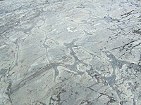 Weathered Precambrian pillow lava in the Temagami Greenstone Belt
 -
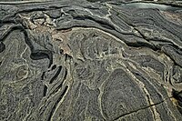 Folded Precambrian gneiss of the Canadian Shield in Georgian Bay, Ontario
 -
 Typical Canadian Shield landscape: spruce, lakes, bogs, and rock


Ecology

The current surface expression of the shield is one of very thin soil lying on top of the bedrock, with many bare outcrops. This arrangement was caused by severe glaciation during the ice ages that covered the shield and scraped the rock clean. The lowlands of the Canadian Shield have a very dense soil that is not suitable for forestation; it also contains many marshes and bogs (muskegs). The rest of the region has coarse soil that does not retain moisture well and is frozen with permafrost throughout the year. Forests are not as dense in the north.
The shield is covered in parts by vast
Many mammals such as
Mining and economics
The Canadian Shield is one of the world's richest areas in terms of
The Flin Flon greenstone belt in central Manitoba and east-central Saskatchewan "is one of the largest Paleoproterozoic volcanic-hosted massive sulfide (VMS) districts in the world, containing 27 copper-zinc-(gold) deposits from which more than 183 million tonnes of sulfide have been mined."[24] The portion in the Northwest Territories has recently been the site of several major diamond discoveries. The kimberlite pipes in which the diamonds are found are closely associated with cratons, which provide the deep lithospheric mantle required to stabilize diamond as a mineral. The kimberlite eruptions then bring the diamonds from over 150 kilometres (93 mi) depth to the surface. The Ekati and Diavik mines are actively mining kimberlite diamonds.
See also
- Baltic Shield
- Athabasca Basin
- Geology of Ontario
- Platform (geology)
- Basement (geology)
- Volcanology of Canada
- Wisconsin glaciation
- Glacial history of Minnesota
References
- ^ a b The Atlas of Canada (12 September 2016). "Physiographic Regions Map". Natural Resources Canada. Retrieved 2019-11-15.
- ^ a b "Canadian Shield". Encyclopædia Britannica. Archived from the original on 2015-06-24. Retrieved 2009-02-10.
- ISBN 978-0393932386.
- ^ James-Abra, Erin. "Canadian Shield". Canadian Encyclopedia. Archived from the original on 11 January 2018. Retrieved 24 January 2018.
- ^ Corrigan, D. (2008). "Metallogeny and Tectonic Evolution of the Trans-Hudson Orogen" (PDF). Archived from the original (PDF) on April 9, 2008. Retrieved 2008-03-05.
- ^ Peterson Field Guide to Geology of Eastern North America by Roberts, David & Roger Tory Peterson.
- Archive-It- The Canadian Shield Region of Alberta
- ^ Tsuyoshi Iizuka, at al., "Geology and Zircon Geochronology of the Acasta Gneiss Complex", Precambrian Research, 153 (2007) pp. 179–208
- ^ Pidwirny, M. (2006). "The Drainage Basin Concept". Fundamentals of Physical Geography (2nd ed.).
- ^
Clark, Bruce W. (1999). "Geologic History". Making Connections: Canada's geography. Scarborough, Ontario: Prentice Hall Ginn Canada. pp. 95. ISBN 978-0-13-012635-1.
- .
- ISBN 0813753023.
- .
- .
- .
- ^ Caldera Volcanoes Archived 2012-08-14 at the Wayback Machine Retrieved on 2007-07-20
- .
- ^ "Barbeau Peak". Bivouac.com.
- ^ World Wildlife Fund, ed. (2001). "Northern Canadian Shield taiga". WildWorld Ecoregion Profile. National Geographic Society. Archived from the original on 2010-03-08.
- ^ C. Michael Hogan (2008) Polar Bear: Ursus maritimus, Globaltwitcher.com, ed. Nicklas Stromberg Archived December 24, 2008, at the Wayback Machine
- ^ "Making Sense of Shield Lakes and Rivers | Northern Ontario Travel". 28 June 2016.
- ^ "Wildlife of the Boreal Shield Ecozone".
- ^ 3-D Magnetic Imaging using Conjugate Gradients: Temagami anomaly Archived 2009-07-11 at the Wayback Machine Retrieved on 2008-03-12
- ^ Troymet Exploration, Report on the 2007 Diamond Drilling Program, McClarty Lake Project, Manitoba: The Pas Mining District NTS 63-K-08; UTM ZONE 14 N 415938 E, 6038968 N; 54° 29′ 28″ N 100° 17′ 52″ W, by Jessica Norris & Tracy Hurley (Whitehorse, Yukon: Aurora Geosciences, 2007‑09‑24).
Further reading
- Schwartzenberger, Tina (2005), The Canadian Shield, Weigl Educational, ISBN 1-55388-141-9