
Østbanegade
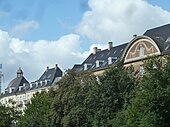
_01.jpg) Østbanegade with a glimpse of Glacisgården at the corner of Trondhjems Plads. | |
| Length | 1,320 m (4,330 ft) |
|---|---|
| Location | Copenhagen, Denmark |
| Postal code | 2100 |
| Coordinates | 55°42′6.48″N 12°35′28.32″E / 55.7018000°N 12.5912000°E |
Østbanegade is a street in
Trondhjems Plads (English: Trondheim Square) is a garden square occupying a triangular space between Østbanegade and Trondhjemsgade.
History
.jpg)
.jpg)
The layout of the street was decided in connection with the plans for the new
, obtained from the west coast of Greenland. The plant existed until 1990.Notable buildings and residents
Glacispalæet (No. 1, literally "The Glacis Mansion") was built between 1900 and 1903 to a design by Andreas Clemmesen. It formerly served as headquarters of the engineering company Monberg & Thorsen. No. 5–7 (Glacispalais, 1903) and No. 9 are stately residential buildings. The street then passes Trondhjems Plads, a garden square which occupies a rectangular space between Østbanegade and Trondhjemsgade. It affords views of the rear side of Domus Medica. Glacisgården at No. 11 was designed by Aage Langelannd-Mathiesen and completed in 1904. It is a rare example of influence from vienese Jugendstyle on Danish architecture.[3] Gefion and Gylfe (No. 19 and 21) are two apartment buildings connected by am archway across Mandalsgade. It was completed in 1902 to a design by Philip Smidth.[4]
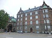
Østerbro Fire Station (No. 99) was designed by Ludvig Fenger and completed in 1901.
Public art

In the garden complex on Trondhjems Plads is Carl Johan Bonnesen's equestrian statue of Diana. It was installed on the square in 1909 as a gift from Carl Jacobsen.[5] The underpass and outer wall of the raised railway at the end of Nordre Frihavnsgade is decorated with Ib Spand Olsen's illustrations from his childhood memoirs from Østerbro.
Transport
The
Image gallery
-
 First part of the street
 -

-
 No. 11: Glacisgaarden
 -
 No. 21: Gylfe, now the Irish Embassy in Copenhagen


References
- ^ "Strandpromenaden - nu Østbanegade, 1896" (in Danish). Museum of Copenhagen. Retrieved 2013-10-14.
- ^ "1895" (in Danish). Selskabet for Københavns Historie. Retrieved 2013-10-13.
- ^ "Sag: Glacisgaarden" (in Danish). Kulturstyrelsen. Retrieved 2013-10-12.
- ^ "Sag: Gylfe" (in Danish). Kulturstyrelsen. Retrieved 2013-10-12.
- ^ "Diana til hest" (in Danish). Københavns Kommune. Retrieved 2013-10-13.