
Řeporyje
Řeporyje | |
|---|---|
Municipal District of Prague Cadastral Area of Prague | |
 Řeporyje town square | |
|
UTC+2 (CEST) | |
| Postal code | 155 00 |
| Website | http://www.prahareporyje.cz |
Řeporyje is a cadastral area of Prague. Most of it belongs to the municipal district of the same name, the rest belonging to Prague 13. Řeporyje became part of Prague in 1974, before which it was recorded as a městys.
The district is situated on Dalejský potok and borders
railway line.Global stratigraphic boundary
Řeporyje is home of a
Přídolí epoch and stage is located in a quarry southwest of Řeporyje (50°01′40″N 14°19′30″E / 50.0277°N 14.3249°E
).
Gallery
-
 Viaduct over Dalejský potok
 -
 The passing loop before Praha-Řeporyje station
 -
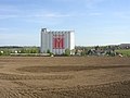 Soufflet Agro silo


Twin town
Řeporyje is twinned with:
Demographics
| Year | Pop. | ±% |
|---|---|---|
| 1869 | 525 | — |
| 1880 | 682 | +29.9% |
| 1890 | 899 | +31.8% |
| 1900 | 1,411 | +57.0% |
| 1910 | 1,823 | +29.2% |
| 1921 | 1,880 | +3.1% |
| 1930 | 2,816 | +49.8% |
| 1950 | 2,949 | +4.7% |
| 1961 | 2,942 | −0.2% |
| 1970 | 2,399 | −18.5% |
| 1980 | 2,559 | +6.7% |
| 1991 | 2,122 | −17.1% |
| 2001 | 2,174 | +2.5% |
| 2011 | 3,727 | +71.4% |
| 2021 | 4,729 | +26.9% |
| Source: Censuses[3] | ||
References
- ^ https://www.czso.cz/csu/czso/vysledky-scitani-2021-otevrena-data
- ^ "Гостомель та район чеської Праги – Ржепоріє стали містами-побратимами". Децентралізація (in Ukrainian). 2023-03-02. Retrieved 2023-06-24.
- ^ "Historický lexikon obcí České republiky 1869–2011 – Praha" (in Czech). Czech Statistical Office. 2015-12-21. pp. 7–8.
External links
| Authority control databases: National |
|---|
This Prague location article is a stub. You can help Wikipedia by expanding it. |