
ATS-3
.png) ATS-3 prelaunch | ||
| Mission type | Weather Communications Technology | |
|---|---|---|
| Operator | NASA | |
| COSPAR ID | 1967-111A | |
| SATCAT no. | 3029 | |
| Mission duration | 56 years, 5 months, 3 days (in orbit) | |
| Spacecraft properties | ||
Hughes | ||
| Launch mass | 365.0 kilograms (804.7 lb) | |
| Start of mission | ||
| Launch date | November 5, 1967, 23:37:00 UTC LC-12 | |
| End of mission | ||
| Deactivated | 2001 | |
| Orbital parameters | ||
| Reference system | Semi-major axis 42,241.0 kilometres (26,247.3 mi) | |
| Eccentricity | 0.00043 | |
| Perigee altitude | 35,723 kilometers (22,197 mi) | |
| Apogee altitude | 35,862 kilometers (22,284 mi) | |
| Inclination | 6.92 degrees | |
| Period | 23.93 hours | |
| Epoch | January 21, 2014, 11:54:19 UTC[2] | |
Applications Technology Satellite 3, or ATS-3, was a long-lived American experimental geostationary weather and communications satellite, operated by NASA from 1967 to 2001.[3] It was at one time reputed to be the oldest satellite still in operation.[4] As of 1995[update], NASA referred to the ATS-3 as "The oldest active communications satellite by a wide margin."[5]
On November 10, 1967, ATS-3 took NASA's first color photo (digital image mosaic) of the full-disk Earth, which was subsequently used on the cover of the first Whole Earth Catalog.
History
Launched in November 1967, the ATS-3 was in service for 11 years before finally being decommissioned in 1978 along with ATS-1.[6] Among its widest-known achievements are the first full-disk, "true color"[7] composite Earth image (DODGE took color-filtered black-and-white images, put together they produced the very first color image of the full-disk).[8] Its imaging capability has served during disaster situations, from the Mexico earthquake to the Mount St. Helens eruption.[5]
ATS-3 experiments included
Because of failures in the hydrogen peroxide systems on ATS-1, ATS-3 was equipped with a hydrazine propulsion system. Its success led to its incorporation on ATS-4 and ATS-5 as the sole propulsion system.[5]
Operational details
The satellite is in
Circa 1970, ATS-3 was used to collect images of weather patterns, especially developing hurricanes in the Western Hemisphere. 1,200 line photos were downlinked, approximately every 25 minutes, during daylight hours to NOAA's Command and Data Acquisition Station at Wallops Station, Virginia and transferred to various users. The satellite was known for its spinning beam antennas locking up and rotating with the satellite. When that happened, it took a powerful ground-based transmitter, like the one at Mojave, to blast through digital instructions to get the antenna aimed back at earth again.[citation needed]
Gallery
-
 Launch of ATS-3
 -
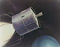 Concept artwork of the ATS-3 satellite.
 -
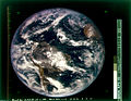 NASA's first color photo (digital image mosaic) of Earth, imaged in 1967 by ATS-3, was used as the cover of Whole Earth Catalog's first edition.
 -
Time-lapse footage of the Earth captured by the NASA ATS III satellite in 1967.
-
 Hurricane Agnes made landfall in Florida on June 18, 1972, seen here from the ATS-3 satellite before moving ashore.
 -
 The April 3-4, 1974, "Super Outbreak" is the second-largest outbreak of tornadoes in the U.S. on record, and holds the record for the most F5 tornadoes on a single day. The image seen here is from the ATS-3 satellite on the afternoon of April 3, 1974, as the outbreak was beginning.
 -
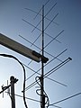 ATS-3 Ground Station Antenna
.jpg)
.jpg)

.jpg)
.jpg)

See also
- 1967 in spaceflight
- First images of Earth from space
- Applications Technology Satellite
References
- ^ McDowell, Jonathan. "Launch Log". Jonathan's Space Page. Retrieved January 24, 2014.
- ^ "ATS 3 Satellite details 1967-111A NORAD 3029". N2YO. January 21, 2014. Retrieved January 24, 2014.
- ^ "ATS | Science Mission Directorate". science.nasa.gov. Retrieved October 27, 2016.
- ^ "Technology". solarstorms.org. Archived from the original on September 28, 2006. Retrieved November 17, 2012.
- ^ a b c Glover, Daniel R. (1997). "Chapter 6: NASA Experimental Communications Satellites, 1958–1995, SP-4217 Beyond the Ionosphere". In Butrica, Andrew J. (ed.). Beyond The Ionosphere: The Development of Satellite Communications. NASA.
- ^ "Applications Technology Satellite Program".
- S2CID 51994278.
- ^ "The First Color Images of the Earth from Space". Geography Realm. March 13, 2019. Retrieved February 2, 2022.
- ^ "NASA – NSSDC – Experiment – Details – Multicolor Spin-Scan Cloudcover Camera (MSSCC)". NASA. Retrieved November 17, 2012.
- ^ Pae, Peter, "Satellites' Longevity Limits Sales", Los Angeles Times, December 1, 2008, p. C1.
External links
| Editors |  | |
|---|---|---|
| Community | ||
| Other publications | ||
| Related topics | ||