
Abiel Peak
| Abiel Peak | |
|---|---|
 North aspect | |
| Highest point | |
| Elevation | 5,365 ft (1,635 m)[1] |
| Prominence | 445 ft (136 m)[2] |
| Parent peak | Silver Peak (5,605 ft)[3] |
| Isolation | 0.71 mi (1.14 km)[3] |
| Coordinates | 47°21′07″N 121°28′09″W / 47.3519239°N 121.4692449°W[4] |
| Naming | |
| Etymology | Abiel W. Tinkham |
| Geography | |
 Abiel Peak Location in Washington  Abiel Peak Abiel Peak (the United States) | |
| Location | |
Abiel Peak is a 5,365 ft (1,640 m) mountain
Topographic relief
is significant as the north aspect rises 1,860 feet (570 meters) above Annette Lake in one-half mile.
Etymology
This geographic landform was named by
U.S. Board on Geographic Names to honor Lieutenant Abiel W. Tinkham.[5][6] He worked as a railroad surveyor when he explored the Snoqualmie Pass area in 1853 and 1854. He is also the namesake of nearby Tinkham Peak, and Tinkham Mountain
in Glacier National Park, Montana.
Climate
Abiel Peak is located in the
snowfall onto the Cascades (Orographic lift). As a result, the west side of the Cascades experiences high precipitation, especially during the winter months in the form of snowfall. Because of maritime influence, snow tends to be wet and heavy, resulting in high avalanche danger.[1] During winter months, weather is usually cloudy, but, due to high pressure systems over the Pacific Ocean that intensify during summer months, there is often little or no cloud cover during the summer.[1]
The months July through September offer the most favorable weather for viewing or climbing this peak.
Gallery
-
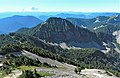 Abiel Peak (centered), Mt. Rainier on the horizon
 -
 North aspect of Abiel Peak, with Mt. Rainier in the distance.
 -
 Abiel Peak in winter, from Annette Lake
 -
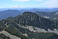 Abiel Peak from Silver Peak


See also
References
- ^ a b c d Beckey, Fred W. Cascade Alpine Guide, Climbing and High Routes. Seattle, WA: Mountaineers Books, 2008.
- ^ "Abiel Peak, Washington". Peakbagger.com.
- ^ a b c "Abiel Peak- 5,365' WA". listsofjohn.com. Retrieved 2022-04-05.
- ^ a b "Abiel Peak". Geographic Names Information System. United States Geological Survey, United States Department of the Interior. Retrieved 2022-04-05.
- ISBN 9781493011889, p. 149
- ISBN 9780295748535, p. 150
External links
- Weather forecast: Abiel Peak