
Aderet, Israel
Aderet
אַדֶּרֶת أديريت | |
|---|---|
| Hebrew transcription(s) | |
| • official | Adderet |
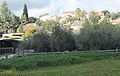
.jpg) Wheat fields outside of Moshav Aderet | |
| Etymology: Glorious (Vine) | |
 Aderet | |
| Coordinates: 31°39′37″N 34°59′43″E / 31.66028°N 34.99528°E | |
| Country | Israel |
| District | Jerusalem |
| Council | Mateh Yehuda |
| Affiliation | Moshavim Movement |
| Founded | 1961 |
| Founded by | Moroccan Jews |
| Government | |
| • Mayor | Motti Gabbai |
| Population (2022)[1] | 895 |
Aderet (Hebrew: אַדֶּרֶת) is a moshav in central Israel. Located in the Judean foothills in the Adullam region, south of Beit Shemesh, west of Gush Etzion and overlooking the Valley of Elah, it falls under the jurisdiction of Mateh Yehuda Regional Council. In 2022 it had a population of 895.[1]
History
The moshav was founded in the early 1959 by Jewish immigrants from Romania. All of the initial settlers, however, left the site. In 1963, the government re-established the town and brought in Jewish immigrants from the Atlas Mountains in Morocco. Its name was taken from Book of Ezekiel 17:8, meaning "mighty" in the phrase "mighty vine", a symbol of reborn Israel.[2] The name recalls the viticulture in the area.
The residents were involved in poultry farming and other agricultural activities until the late 1980s, when the village evolved into a dormitory community for Jerusalem (40 km) and Tel Aviv (65 km). In 1997 a new neighborhood was built, bringing the population to over 110 families. An additional building project started in late 2006 for seventy plots.
Education
There are two
Tourism
In the vicinity of Aderet are a
Gallery
-
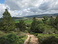
 Panoramic view ofElah Valleyas seen from atop Moshav Aderet
 -
 Houses in Aderet
 -
 General view of Aderet
 -
 Houses and gardens in Aderet
 -
 Country road near Aderet
 -
 Aderet


,_known_as_Aderet.jpg)


References
- ^ a b "Regional Statistics". Israel Central Bureau of Statistics. Retrieved 21 March 2024.
- ISBN 965-220-423-4(Hebrew). English translation follows the Judeo-Arabic translation of the Hebrew "aderet" = ביזאלה (بِزاله), in Ezekiel 17:8, published in Yosef Tobi's Poetry, Judeo-Arabic Literature and the Geniza, Tel-Aviv 2006, pp. 56; 62 (Hebrew)
| International | |
|---|---|
| National | |